 |
|
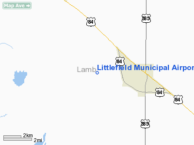
Location & QuickFacts
| FAA Information Effective: | 2008-09-25 |
| Airport Identifier: | LIU |
| Airport Status: | Operational |
| Longitude/Latitude: | 102-23-12.0256W/33-55-26.1991N
-102.386674/33.923944 (Estimated) |
| Elevation: | 3616 ft / 1102.16 m (Surveyed) |
| Land: | 226 acres |
| From nearest city: | 3 nautical miles W of Littlefield, TX |
| Location: | Lamb County, TX |
| Magnetic Variation: | 10E (1980) |
Owner & Manager
| Ownership: | Publicly owned |
| Owner: | City Of Littlefield |
| Address: | Box 1267
Littlefield, TX 79339 |
| Phone number: | 806-385-5161 |
| Manager: | Tom Brown |
| Address: | Box 1102
Littlefield, TX 79339 |
| Phone number: | 806-385-3143 |
Airport Operations and Facilities
| Airport Use: | Open to public |
| Wind indicator: | Yes |
| Segmented Circle: | Yes |
| Control Tower: | No |
| Lighting Schedule: | DUSK-DAWN |
| Beacon Color: | Clear-Green (lighted land airport) |
| Landing fee charge: | No |
| Sectional chart: | Albuquerque |
| Region: | ASW - Southwest |
| Boundary ARTCC: | ZFW - Fort Worth |
| Tie-in FSS: | FTW - Fort Worth |
| FSS on Airport: | No |
| FSS Phone: | 817-541-3474 |
| FSS Toll Free: | 1-800-WX-BRIEF |
| NOTAMs Facility: | FTW (NOTAM-d service avaliable) |
| Federal Agreements: | NGY |
Airport Communications
| CTAF: | 122.800 |
| Unicom: | 122.800 |
Airport Services
| Fuel available: | 100LL
FOR FUEL AFT HRS CALL 806-777-5030, 806-778-1418/8848 OR 806-241-0761. |
| Airframe Repair: | MINOR |
| Power Plant Repair: | MINOR |
| Bottled Oxygen: | NONE |
| Bulk Oxygen: | NONE |
Runway Information
Runway 01/19
| Dimension: | 4021 x 60 ft / 1225.6 x 18.3 m |
| Surface: | ASPH, Good Condition |
| Weight Limit: | Single wheel: 12000 lbs. |
| Edge Lights: | Medium |
| |
Runway 01 |
Runway 19 |
| Longitude: | 102-23-18.4443W | 102-23-04.2880W |
| Latitude: | 33-55-11.9735N | 33-55-49.9533N |
| Elevation: | 3611.00 ft | 3608.00 ft |
| Alignment: | 17 | 127 |
| Traffic Pattern: | Left | Left |
| Markings: | Non-precision instrument, Good Condition | Non-precision instrument, Fair Condition |
| Obstruction: | 38 ft tree, 920.0 ft from runway, 115 ft right of centerline, 18:1 slope to clear | , 50:1 slope to clear |
|
Runway 13/31
| Dimension: | 2513 x 40 ft / 766.0 x 12.2 m |
| Surface: | ASPH, Fair Condition |
| Weight Limit: | Single wheel: 5000 lbs. |
| |
Runway 13 |
Runway 31 |
| Longitude: | 102-23-23.5154W | 102-23-02.6454W |
| Latitude: | 33-55-27.4526N | 33-55-09.6997N |
| Elevation: | 3616.00 ft | 3607.00 ft |
| Alignment: | 127 | 127 |
| Traffic Pattern: | Left | Left |
| Markings: | Basic, Fair Condition | Basic, Fair Condition |
| Obstruction: | 8 ft road, 320.0 ft from runway, 137 ft right of centerline, 15:1 slope to clear | 20 ft pline, 675.0 ft from runway, 172 ft left of centerline, 23:1 slope to clear |
|
Radio Navigation Aids
| ID |
Type |
Name |
Ch |
Freq |
Var |
Dist |
| LIU | NDB | Littlefield | | 212.00 | 10E | 0.3 nm |
| LLN | NDB | Levelland | | 266.00 | 09E | 22.1 nm |
| BFE | NDB | Brownfield | | 311.00 | 09E | 45.8 nm |
| PVW | VOR/DME | Plainview | 076X | 112.90 | 11E | 31.3 nm |
| LBB | VORTAC | Lubbock | 029X | 109.20 | 11E | 27.0 nm |
| TXO | VORTAC | Texico | 059X | 112.20 | 11E | 41.1 nm |
Remarks
- GLIDER OPNS SR-SS WEEKENDS.
- HANGARS OBSTRUCT TRANSITIONAL SFC RWY 13/31.
Images and information placed above are from
http://www.airport-data.com/airport/LIU/
We thank them for the data!
| General Info
|
| Country |
United States
|
| State |
TEXAS
|
| FAA ID |
LIU
|
| Latitude |
33.923944
33° 55' 26.20" N
|
| Longitude |
-102.386675
102° 23' 12.03" W
|
| Elevation |
3616 feet
1102 meters
|
| Type |
Civil
|
| Magnetic Variation |
007° E (01/06)
|
| Beacon |
Yes
|
| Operating Agency |
U.S.CIVIL AIRPORT WHEREIN PERMIT COVERS USE BY TRANSIT MILITARY AIRCRAFT
|
| Daylight Saving Time |
Second Sunday in March at 0200 to first Sunday in November at 0200 local time (Exception Arizona and that portion of Indiana in the Eastern Time Zone)
|
We don't guarantee the information is fresh and accurate. The data may
be wrong or outdated.
For more up-to-date information please refer to other sources.
|
|


