|
 |
|
||||
|
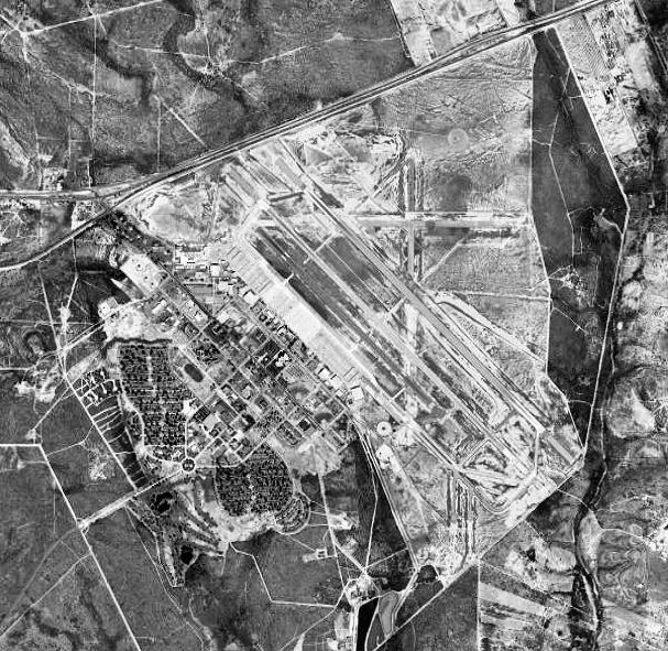
Laughlin Air Force Base (IATA: DLF, ICAO: KDLF, FAA LID: DLF) is a facility of the United States Air Force located five miles (8 km) east of the central business district (CBD) of Del Rio, Texas, close to the border of the United States with Mexico. It was named after Del Rio native Jack T. Laughlin. Laughlin AFB, the largest pilot training base in the USAF, is home to the 47th Flying Training Wing of the Air Education and Training Command (AETC). On weekdays, the airfield sees more takeoffs and landings than any other airport in the country. The residential area of the base is a census-designated place (CDP), with a population of 2,225 at the 2000 census. HistoryLaughlin AFB was originally named Laughlin Army Air Field on March 3, 1943, after Jack T. Laughlin, a B-17 Flying Fortress navigator who became Del Rio's first WWII casualty when his plane was shot down over Java in January 1942. The field became simply Laughlin Field on November 11, 1943 and later an Army Air Force Auxiliary Field. It was closed in October 1945. Laughlin Air Force Base reopened on May 1, 1952. In October 1952, ATC transferred the base to Crew Training Air Force (CREWTAF) and activated the 3645th Flying Training Wing (Fighter), as a combat crew replacement training facility for pilots headed for Korea. Training provided new pilots with basic bombing and gunnery combat skills in the F-80 Shooting Star, F-84 Thunderjet, and T-33 jet aircraft, but within a short time crews used only the T-33. In Sept. 1955, Laughlin came under the control of the Flying Training Air Force and switched missions with Williams Air Force Base, Arizona. Laughlin undertook single-engine pilot training, still using the T-33. The Air Force transferred jurisdiction of the base to the Strategic Air Command on April 1, 1957 and the 4080th Strategic Reconnaissance Wing (Light) moved there from Turner Air Force Base, Georgia. Following graduation of the last class in March 1957, ATC inactivated the 3645th FTW. The 4080th Wing provided high-altitude reconnaissance and air sampling using the Lockheed U-2A and the RB-57D Canberra. The 4080th Strategic Reconnaissance Wing was redesignated the 4080th Strategic Wing on June 15, 1960, and the RB-57 mission was phased out. Laughlin U-2s were among the first to provide photographic evidence of Soviet missile installations in Cuba in 1962 when 4080th U-2 pilot Major Steve Heyser flew his U-2C over Cuba after taking off from Edwards AFB, California. Heyser landed at McCoy AFB, Florida, following the mission, with McCoy becoming a U-2 operating location for the duration of the Cuban Missile Crisis. The film from Major Heyser's mission was developed and analyzed and these same photos were shown to the United Nations Security Council on October 22, 1962, proving to the world that offensive missiles were being erected on the island of Cuba. Another 4080th pilot, Major Rudolf Anderson, Jr., perished when his U-2 was hit by shrapnel from a Soviet-made SA-2 on October 22, 1962 while overflying Cuba. While not suffering a direct hit, Anderson was struck by fragments from the missile warhead's proximity explosion that penetrated and compromised his pressure suit. His body was returned to the U.S. following the crisis, still clad in its pressure suit. Major Anderson posthumously became the first recipient of the Air Force Cross, the Air Force's second highest decoration for valor. Laughlin's primary operations training complex, Anderson Hall, is named in his honor. In 1961, Headquarters US Air Force notified Laughlin officials their mission would expand to again include an Air Training Command undergraduate pilot training program. Plans called to transfer in about half the student load from Laredo Air Force Base, Texas. ATC reactivated the 3645th Pilot Training Wing (later redesignated 3646th Pilot Training Wing) at Laughlin in October 1961 to prepare for the phase-in of students and T-37 and T-33 trainers. The 4080th SW continued at Laughlin as a tenant organization until 1963. Today, aircraft flown at Laughlin include the T-6A Texan II, the T-38C Talon and T-1A Jayhawk. Fifteen classes of approximately 20-25 pilots each are graduated every year. Local entertainmentAside from the reservoir outside of Del Rio for fishing and some lake diving, most forms of recreation are either in the town of Del Rio or across the border in Ciudad Acuña. GeographyLaughlin Air Force Base is located at 29°20′52″N 100°47′18″W / 29.34778°N 100.78833°W. According to the United States Census Bureau, the base has a total area of 5.9 square miles (15.3 km), all of it land. DemographicsAs of the census of 2000, there were 2,225 people, 651 households, and 570 families residing on the base. The population density was 377.6 people per square mile (145.9/km). There were 664 housing units at an average density of 112.7/sq mi (43.5/km). The racial makeup of the base was 78.38% White, 10.65% African American, 0.27% Native American, 2.74% Asian, 0.09% Pacific Islander, 4.49% from other races, and 3.37% from two or more races. Hispanic or Latino of any race were 12.31% of the population. There were 651 households out of which 56.1% had children under the age of 18 living with them, 82.8% were married couples living together, 3.4% had a female householder with no husband present, and 12.3% were non-families. 6.6% of all households were made up of individuals and none had someone living alone who was 65 years of age or older. The average household size was 3.00 and the average family size was 3.18. On the base the population was spread out with 30.6% under the age of 18, 23.6% from 18 to 24, 42.7% from 25 to 44, 2.5% from 45 to 64, and 0.6% who were 65 years of age or older. The median age was 24 years. For every 100 females there were 130.1 males. For every 100 females age 18 and over, there were 136.4 males. The median income for a household on the base was $38,625, and the median income for a family was $38,625. Males had a median income of $26,938 versus $19,643 for females. The per capita income for the base was $15,121. About 3.1% of families and 4.6% of the population were below the poverty line, including 5.8% of those under age 18 and none of those age 65 or over. EducationLaughlin AFB is served by the San Felipe Del Rio Consolidated Independent School District. The above content comes from Wikipedia and is published under free licenses – click here to read more.
Location & QuickFacts
Owner & Manager
Airport Operations and Facilities
Airport Services
Runway InformationRunway 13C/31C
Runway 13L/31R
Runway 13R/31L
Radio Navigation Aids
Remarks
Images and information placed above are from We thank them for the data!
We don't guarantee the information is fresh and accurate. The data may
be wrong or outdated.
|
||||||||||||||||||||||||||||||||||||||||||||||||||||||||||||||||||||||||||||||||||||||||||||||||||||||||||||||||||||||||||||||||||||||||||||||||||||||||||||||||||||||||||||||||||||||||||||||||||||||||||||||||||||||||||||||||||||||||||||||||||||||||||||||||||||||||||||||||||||||||||||||||||||||||||||||||||||||||||||||||||||||||||||||||

 |
|
Copyright 2004-2026 © by Airports-Worldwide.com, Vyshenskoho st. 36, Lviv 79010, Ukraine Legal Disclaimer |