|
|
| Lakeview Airport |
| IATA: none – ICAO: none – FAA LID: 30F |
| Summary |
| Airport type |
Private |
| Operator |
Squier Family |
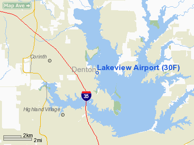
| Location |
Lake Dallas, Texas |
| Elevation AMSL |
535 ft / 163 m |
| Coordinates |
33°07′55″N 97°00′51″W / 33.13194°N 97.01417°W / 33.13194; -97.01417Coordinates: 33°07′55″N 97°00′51″W / 33.13194°N 97.01417°W / 33.13194; -97.01417 |
| Runways |
| Direction |
Length |
Surface |
| ft |
m |
| 18/36 |
2,815 |
858 |
poor Asphalt |
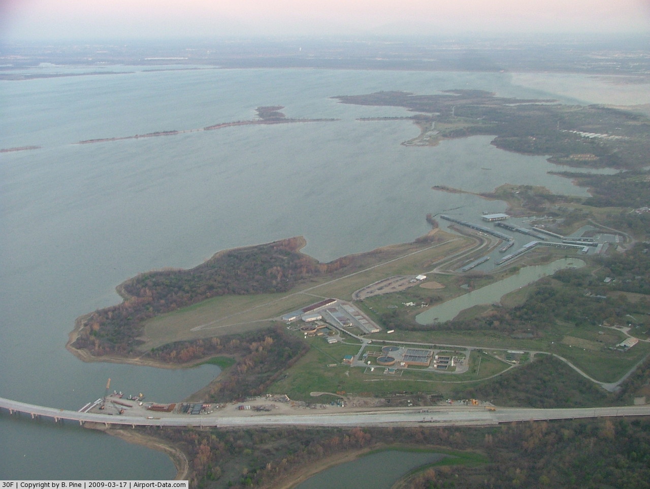
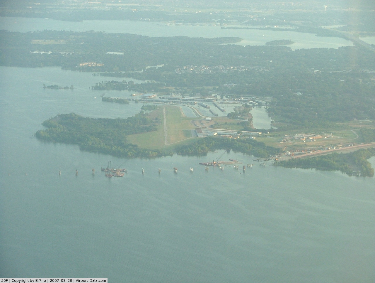
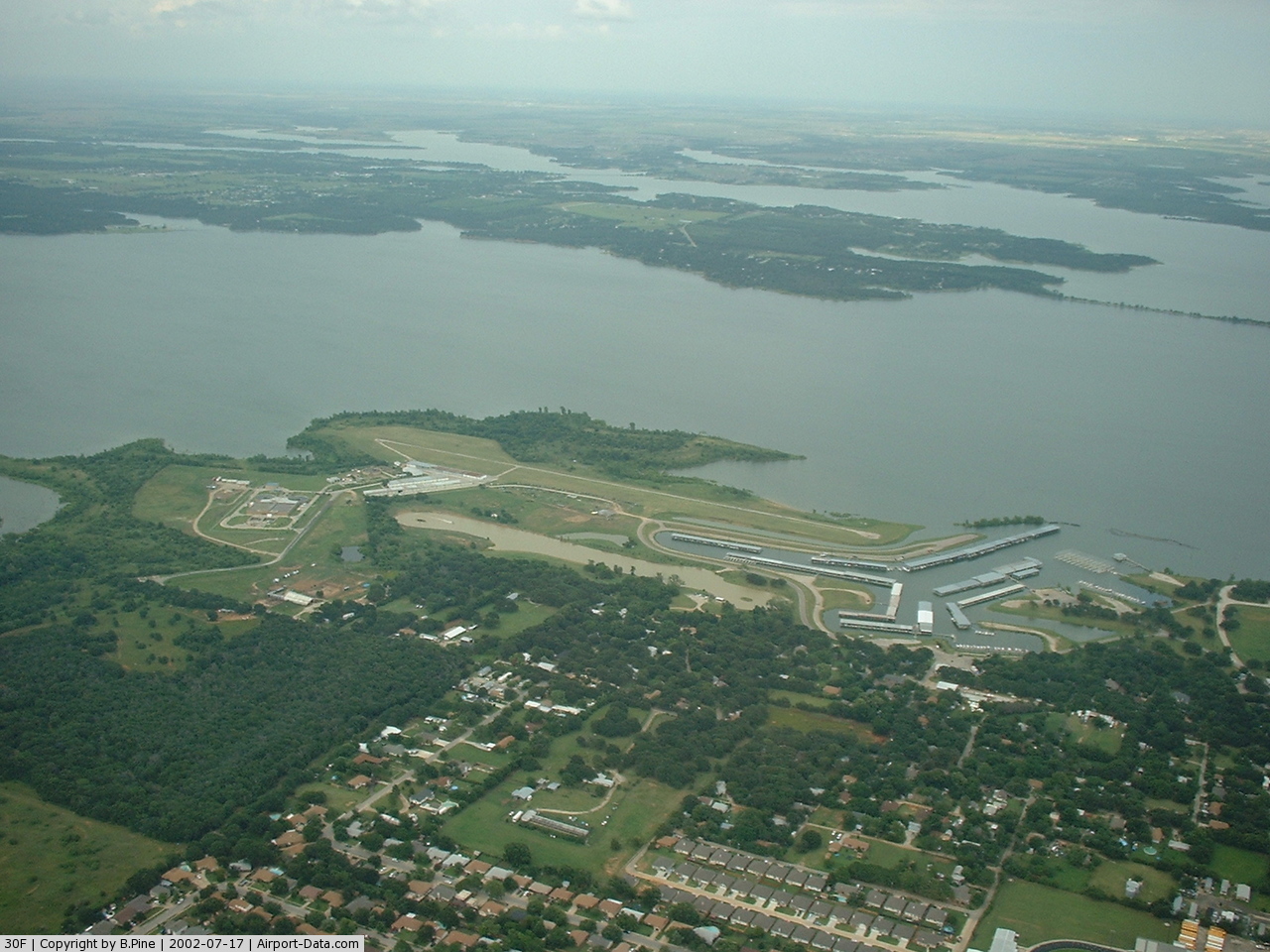
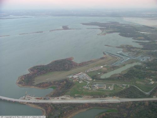
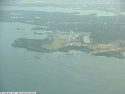
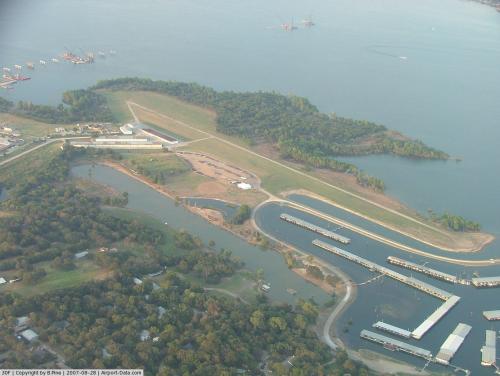
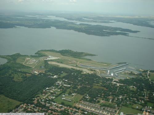
Lakeview Airport (FAA LID: 30f) is a private airport located one mile (1.6 km) east of the central business district (CBD) of Lake Dallas, in Denton County, Texas, USA.
As of 2008 the paved airstrip is closed. Only the grass strip is usable. This airport is closed to transient student traffic. No fuel service is available. Soon, the paved airstip will open!
The above content comes from Wikipedia and is published under free licenses – click here to read more.
 |
(Click on the photo to enlarge) |
 |
(Click on the photo to enlarge) |
 |
(Click on the photo to enlarge) |
 |
(Click on the photo to enlarge) |
Location & QuickFacts
| FAA Information Effective: | 2008-09-25 |
| Airport Identifier: | 30F |
| Airport Status: | Operational |
| Longitude/Latitude: | 097-00-51.0290W/33-07-55.4330N
-97.014175/33.132065 (Estimated) |
| Elevation: | 535 ft / 163.07 m (Estimated) |
| Land: | 15 acres |
| From nearest city: | 1 nautical miles NE of Lake Dallas, TX |
| Location: | Denton County, TX |
| Magnetic Variation: | 07E (1985) |
Owner & Manager
| Ownership: | Publicly owned |
| Owner: | U S Govt & Squier Family
ARPT PROPERTY SOUTH FM S-TWY LEASED FROM U.S. GOVT-CORPS OF ENGINEERS BY LAKE DALLAS BOAT WORKS & B. COTHRAN; BLDG AREA & RWY NORTH OF S-TWY OWNED BY MR. W.G. SQUIER. |
| Address: | Po Box 1026
Lake Dallas, TX 75065 |
| Phone number: | 214-493-0052 |
| Manager: | Squier Family |
| Address: | Po Box 1026
Lake Dallas, TX 75065 |
| Phone number: | 214-493-0052 |
Airport Operations and Facilities
| Airport Use: | Open to public |
| Wind indicator: | Yes |
| Segmented Circle: | No |
| Control Tower: | No |
| Landing fee charge: | No |
| Sectional chart: | Dallas-ft Worth |
| Region: | ASW - Southwest |
| Boundary ARTCC: | ZFW - Fort Worth |
| Tie-in FSS: | FTW - Fort Worth |
| FSS on Airport: | No |
| FSS Phone: | 817-541-3474 |
| FSS Toll Free: | 1-800-WX-BRIEF |
| NOTAMs Facility: | FTW (NOTAM-d service avaliable) |
Airport Communications
Airport Services
| Airframe Repair: | MAJOR |
| Power Plant Repair: | MAJOR |
| Bottled Oxygen: | NONE |
| Bulk Oxygen: | NONE |
Runway Information
Runway 18L/36R
| Dimension: | 2815 x 30 ft / 858.0 x 9.1 m |
| Surface: | ASPH, Poor Condition
NUMEROUS PAVEMENT FAILURES WITH LOOSE AGGREGATE. |
| Weight Limit: | Single wheel: 4000 lbs. |
| |
Runway 18L |
Runway 36R |
| Traffic Pattern: | Left | Left |
| Obstruction: | 25 ft trees, 400.0 ft from runway, 8:1 slope to clear
26 FT TREE 193 FT RIGHT OF CENTERLINE 161 FT FM THLD. | 20 ft pole, 310.0 ft from runway, 100 ft left of centerline, 5:1 slope to clear |
|
Runway 18R/36L
| Dimension: | 2600 x 75 ft / 792.5 x 22.9 m |
| Surface: | TURF, Fair Condition
NUMEROUS PAVEMENT FAILURES WITH LOOSE AGGREGATE. |
| |
Runway 18R |
Runway 36L |
| Traffic Pattern: | Left | Left |
| Obstruction: | 40 ft trees, 284.0 ft from runway, 217 ft right of centerline, 7:1 slope to clear | 20 ft poles, 462.0 ft from runway, 23:1 slope to clear |
|
Radio Navigation Aids
| ID |
Type |
Name |
Ch |
Freq |
Var |
Dist |
| RBD | NDB | Redbird | | 287.00 | 06E | 28.3 nm |
| PQF | NDB | Mesquite | | 248.00 | 06E | 31.2 nm |
| XQH | NDB | Cedar Hill | | 353.00 | 08E | 32.6 nm |
| LNC | NDB | Lancaster | | 239.00 | 06E | 36.5 nm |
| GLE | NDB | Gainesville | | 330.00 | 06E | 36.5 nm |
| JUG | NDB | Jecca | | 388.00 | 06E | 37.0 nm |
| MII | NDB | Caddo Mills | | 316.00 | 06E | 38.9 nm |
| AVZ | NDB | Travis | | 260.00 | 06E | 44.6 nm |
| DNI | NDB | Denison | | 341.00 | 06E | 45.0 nm |
| GMZ | NDB | Grindstone Mountain | | 356.00 | 07E | 47.6 nm |
| SYW | NDB | Cash | | 428.00 | 05E | 48.5 nm |
| NFW | TACAN | Nas Jrb Fort Worth | 024X | | 07E | 30.5 nm |
| MJF | TACAN | Arvilla | 033X | | 05E | 48.1 nm |
| CVE | VOR/DME | Cowboy | 109X | 116.20 | 06E | 15.6 nm |
| TTT | VOR/DME | Maverick | 078X | 113.10 | 06E | 15.9 nm |
| FUZ | VORTAC | Ranger | 104X | 115.70 | 06E | 16.8 nm |
| BYP | VORTAC | Bonham | 093X | 114.60 | 06E | 46.1 nm |
| UKW | VORTAC | Bowie | 071X | 112.40 | 06E | 47.2 nm |
| DAL | VOT | Dallas Love Field | | 113.30 | | 19.0 nm |
| FTW | VOT | Fort Worth Meacham | | 108.20 | | 25.7 nm |
Remarks
- NO TGL PERMITTED.
- ARPT CLSD TO TRANSIENT STUDENTS.
- BIRDS ON AND INVOF ARPT.
- 150 FT AGL UNLGTD CRANES 1000 FT NNW OF ARPT.
- PRE-DATES THE ACT.
Images and information placed above are from
http://www.airport-data.com/airport/30F/
We thank them for the data!
| General Info
|
| Country |
United States
|
| State |
TEXAS
|
| FAA ID |
30F
|
| Latitude |
33-07-55.433N
|
| Longitude |
097-00-51.029W
|
| Elevation |
535 feet
|
| Near City |
LAKE DALLAS
|
We don't guarantee the information is fresh and accurate. The data may
be wrong or outdated.
For more up-to-date information please refer to other sources.
|
|