 |
|
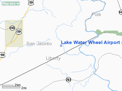
Location & QuickFacts
| FAA Information Effective: | 2008-09-25 |
| Airport Identifier: | XS99 |
| Airport Status: | Operational |
| Longitude/Latitude: | 094-54-45.7520W/30-28-15.7380N
-94.912709/30.471038 (Estimated) |
| Elevation: | 80 ft / 24.38 m (Estimated) |
| Land: | 0 acres |
| From nearest city: | 5 nautical miles E of Shepherd, TX |
| Location: | San Jacinto County, TX |
| Magnetic Variation: | 05E (1985) |
Owner & Manager
| Ownership: | Privately owned |
| Owner: | Lake Waterwheel Property Assn |
| Address: | Route 1, Box 1
Cleveland, TX 77327 |
| Manager: | Mark Schumacher |
| Address: | Rute 1 Box 36
Cleveland, TX 77327 |
| Phone number: | 713-592-3001 |
Airport Operations and Facilities
| Airport Use: | Private |
| Wind indicator: | Yes |
| Segmented Circle: | No |
| Control Tower: | No |
| Landing fee charge: | No |
| Sectional chart: | Houston |
| Region: | ASW - Southwest |
| Boundary ARTCC: | ZHU - Houston |
| Tie-in FSS: | CXO - Montgomery County |
| FSS on Airport: | No |
| FSS Toll Free: | 1-800-WX-BRIEF |
Airport Services
| Airframe Repair: | NONE |
| Power Plant Repair: | NONE |
Runway Information
Runway 11/29
| Dimension: | 2600 x 100 ft / 792.5 x 30.5 m |
| Surface: | TURF, |
| |
Runway 11 |
Runway 29 |
| Traffic Pattern: | Left | Left |
| Obstruction: | 75 ft trees, 200.0 ft from runway | 75 ft trees, 400.0 ft from runway |
|
Radio Navigation Aids
| ID |
Type |
Name |
Ch |
Freq |
Var |
Dist |
| BVP | NDB | Nixin | | 326.00 | 05E | 32.7 nm |
| HRD | NDB | Hardin County | | 524.00 | 04E | 34.8 nm |
| UTS | NDB | Huntsville | | 308.00 | 06E | 38.6 nm |
| DWH | NDB | David Hooks | | 521.00 | 05E | 39.8 nm |
| CBC | NDB | Anahuac | | 413.00 | 05E | 43.9 nm |
| GDE | NDB | Goodhue | | 368.00 | 07E | 44.1 nm |
| JPA | NDB | Sanjac | | 347.00 | 05E | 48.9 nm |
| EYQ | NDB | Weiser | | 286.00 | 06E | 49.7 nm |
| DAS | VORTAC | Daisetta | 116X | 116.90 | 05E | 21.9 nm |
| IAH | VORTAC | Humble | 113X | 116.60 | 05E | 38.2 nm |
| LFK | VORTAC | Lufkin | 058X | 112.10 | 05E | 42.8 nm |
Images and information placed above are from
http://www.airport-data.com/airport/XS99/
We thank them for the data!
| General Info
|
| Country |
United States
|
| State |
TEXAS
|
| FAA ID |
XS99
|
| Latitude |
30-28-15.738N
|
| Longitude |
094-54-45.752W
|
| Elevation |
80 feet
|
| Near City |
SHEPHERD
|
We don't guarantee the information is fresh and accurate. The data may
be wrong or outdated.
For more up-to-date information please refer to other sources.
|
|


