 |
|
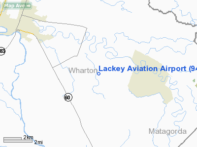
Location & QuickFacts
| FAA Information Effective: | 2008-09-25 |
| Airport Identifier: | 94R |
| Airport Status: | Operational |
| Longitude/Latitude: | 096-00-27.8420W/29-15-57.8950N
-96.007734/29.266082 (Estimated) |
| Elevation: | 90 ft / 27.43 m (Estimated) |
| Land: | 42 acres |
| From nearest city: | 5 nautical miles SE of Wharton, TX |
| Location: | Wharton County, TX |
| Magnetic Variation: | 06E (1985) |
Owner & Manager
| Ownership: | Privately owned |
| Owner: | Thomas P. Lackey Jr. |
| Address: | 7707 Fm 3012
Wharton, TX 77488 |
| Phone number: | 979-532-4931 |
| Manager: | Thomas P. Lackey Jr. |
| Address: | 7707 Fm 3012
Wharton, TX 77488 |
| Phone number: | 979-532-4931 |
Airport Operations and Facilities
| Airport Use: | Open to public |
| Wind indicator: | Yes |
| Segmented Circle: | No |
| Control Tower: | No |
| Landing fee charge: | No |
| Sectional chart: | Houston |
| Region: | ASW - Southwest |
| Boundary ARTCC: | ZHU - Houston |
| Tie-in FSS: | CXO - Montgomery County |
| FSS on Airport: | No |
| FSS Toll Free: | 1-800-WX-BRIEF
FOR FP FILING CALL CXO FSS 1-800-992-7433. |
| NOTAMs Facility: | CXO (NOTAM-d service avaliable) |
Airport Communications
Runway Information
Runway 15/33
| Dimension: | 2167 x 20 ft / 660.5 x 6.1 m |
| Surface: | ASPH, Fair Condition |
| |
Runway 15 |
Runway 33 |
| Traffic Pattern: | Left | Left |
| Obstruction: | 5 ft fence, 200.0 ft from runway, 64 ft left of centerline
+5 FT FENCE AT THLD 64 FT LEFT & 115 FT RIGHT. +35 FT TREE 53 FT LEFT ALONG RY. 20 FT TREE 120 FT RIGHT OF CNTRLN. | 15 ft bldg, 598.0 ft from runway, 125 ft left of centerline, 26:1 slope to clear
+4 FT FENCE ACROSS RY THLD; +5 FT FENCE AT THLD 53 FT RIGHT. +35 FT TREE 53 FT RIGHT ALONG RY. |
|
Radio Navigation Aids
| ID |
Type |
Name |
Ch |
Freq |
Var |
Dist |
| ARM | NDB | Wharton | | 245.00 | 06E | 7.6 nm |
| BYY | NDB | Bay City | | 344.00 | 06E | 19.3 nm |
| SGR | NDB | Hull | | 388.00 | 05E | 28.7 nm |
| SYG | NDB | Sandy Point | | 402.00 | 05E | 31.6 nm |
| LYD | NDB | Lakeside | | 249.00 | 05E | 37.3 nm |
| EYQ | NDB | Weiser | | 286.00 | 06E | 44.5 nm |
| EFD | TACAN | Ellington | 031X | | 05E | 48.9 nm |
| ELA | VOR/DME | Eagle Lake | 111X | 116.40 | 08E | 28.8 nm |
| HUB | VOR/DME | Hobby | 118X | 117.10 | 05E | 44.9 nm |
| PSX | VORTAC | Palacios | 120X | 117.30 | 08E | 34.0 nm |
| HOU | VOT | Houston Wm P Hobby | | 108.40 | | 44.4 nm |
Images and information placed above are from
http://www.airport-data.com/airport/94R/
We thank them for the data!
| General Info
|
| Country |
United States
|
| State |
TEXAS
|
| FAA ID |
94R
|
| Latitude |
29-15-57.895N
|
| Longitude |
096-00-27.842W
|
| Elevation |
90 feet
|
| Near City |
WHARTON
|
We don't guarantee the information is fresh and accurate. The data may
be wrong or outdated.
For more up-to-date information please refer to other sources.
|
|


