 |
|
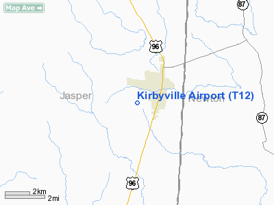
Location & QuickFacts
| FAA Information Effective: | 2008-09-25 |
| Airport Identifier: | T12 |
| Airport Status: | Operational |
| Longitude/Latitude: | 093-54-53.6520W/30-38-47.6340N
-93.914903/30.646565 (Estimated) |
| Elevation: | 121 ft / 36.88 m (Estimated) |
| Land: | 200 acres |
| From nearest city: | 2 nautical miles SW of Kirbyville, TX |
| Location: | Jasper County, TX |
| Magnetic Variation: | 05E (1985) |
Owner & Manager
| Ownership: | Publicly owned |
| Owner: | Jasper County |
| Address: | Jasper County Courthouse
Jasper, TX 75951 |
| Phone number: | 409-384-2612 |
| Manager: | Joe Folk
COUNTY JUDGE. |
| Address: | 121 N. Austin, Room 106
Jasper, TX 75951 |
| Phone number: | 409-423-3572 |
Airport Operations and Facilities
| Airport Use: | Open to public |
| Wind indicator: | Yes |
| Segmented Circle: | No |
| Control Tower: | No |
| Landing fee charge: | No |
| Sectional chart: | Houston |
| Region: | ASW - Southwest |
| Boundary ARTCC: | ZHU - Houston |
| Tie-in FSS: | CXO - Montgomery County |
| FSS on Airport: | No |
| FSS Toll Free: | 1-800-WX-BRIEF
FOR FP FILING CALL CXO FSS 1-800-833-5602 |
| NOTAMs Facility: | CXO (NOTAM-d service avaliable) |
Airport Communications
Airport Services
| Airframe Repair: | MAJOR |
| Power Plant Repair: | MAJOR |
Runway Information
Runway 04/22
| Dimension: | 1983 x 45 ft / 604.4 x 13.7 m |
| Surface: | ASPH, Poor Condition
1 FT TALL WEEDS GROWING ON RY. |
| Weight Limit: | Single wheel: 8000 lbs. |
| |
Runway 04 |
Runway 22 |
| Longitude: | 093-54-58.7050W | 093-54-42.9580W |
| Latitude: | 30-38-36.1130N | 30-38-50.2470N |
| Elevation: | 117.00 ft | 117.00 ft |
| Alignment: | 44 | 127 |
| Traffic Pattern: | Left | Left |
| Obstruction: | 50 ft trees, 300.0 ft from runway, 70 ft left of centerline, 2:1 slope to clear | 75 ft trees, 425.0 ft from runway, 150 ft right of centerline, 3:1 slope to clear
+5 FT BRUSH 40 FT FM THLD ACROSS APCH. |
|
Runway 13/31
| Dimension: | 3746 x 50 ft / 1141.8 x 15.2 m |
| Surface: | ASPH, Good Condition
1 FT TALL WEEDS GROWING ON RY. |
| Weight Limit: | Single wheel: 8000 lbs. |
| |
Runway 13 |
Runway 31 |
| Longitude: | 093-55-10.9020W | 093-54-39.5250W |
| Latitude: | 30-39-02.6330N | 30-38-37.3590N |
| Elevation: | 120.00 ft | 115.00 ft |
| Alignment: | 127 | 127 |
| Traffic Pattern: | Left | Left |
| Markings: | Basic, Good Condition | Basic, Good Condition |
| Displaced threshold: | 326.00 ft | 226.00 ft |
| Obstruction: | 15 ft bldg, 245.0 ft from runway, 125 ft right of centerline, 3:1 slope to clear
APCH SLOPE 20:1 TO 50 FT TREE 1000 FT FM DSPLCD THLD 70 FT RT.
ROAD 110 FT FM THLD ACROSS APCH, 15 FT TREE 130 FT FM THLD 20 FT RT. | 21 ft trees, 267.0 ft from runway, 125L/ ft right of centerline, 3:1 slope to clear
APCH SLOPE 17:1 TO 35 FT TREES 595 FT FM DSPLCD THLD ACROSS APCH.
10 FT TREE 150 FT FM THLD ON CENTERLINE. |
|
Radio Navigation Aids
| ID |
Type |
Name |
Ch |
Freq |
Var |
Dist |
| POE | FAN MARKER | South | | | 07E | 43.6 nm |
| POE1 | FAN MARKER | North | | | 07E | 45.4 nm |
| JAS | NDB | Jasper | | 344.00 | 04E | 19.5 nm |
| HRD | NDB | Hardin County | | 524.00 | 04E | 25.8 nm |
| DQU | NDB | De Quincy | | 410.00 | 05E | 26.4 nm |
| DR | NDB | Idder | | 385.00 | 04E | 30.7 nm |
| ORG | NDB | Orange | | 211.00 | 05E | 35.2 nm |
| UX | NDB | Sulfy | | 278.00 | 04E | 37.2 nm |
| GDE | NDB | Goodhue | | 368.00 | 07E | 37.7 nm |
| VED | NDB | Leesville | | 247.00 | 04E | 40.3 nm |
| GUV | NDB | Gator | | 359.00 | 05E | 44.1 nm |
| BPT | VOR/DME | Beaumont | 092X | 114.50 | 07E | 42.4 nm |
| FXU | VORTAC | Polk | 021X | 108.40 | 05E | 45.5 nm |
| DAS | VORTAC | Daisetta | 116X | 116.90 | 05E | 46.8 nm |
Remarks
Images and information placed above are from
http://www.airport-data.com/airport/T12/
We thank them for the data!
| General Info
|
| Country |
United States
|
| State |
TEXAS
|
| FAA ID |
T12
|
| Latitude |
30-38-47.634N
|
| Longitude |
093-54-53.652W
|
| Elevation |
121 feet
|
| Near City |
KIRBYVILLE
|
We don't guarantee the information is fresh and accurate. The data may
be wrong or outdated.
For more up-to-date information please refer to other sources.
|
|


