 |
|
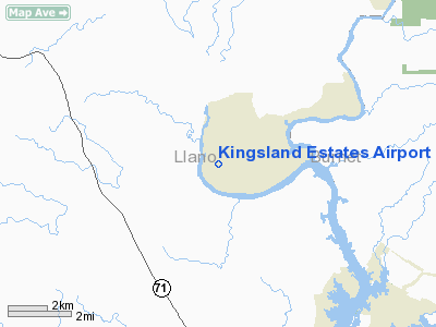
Kingsland Estates Airport |
Location & QuickFacts
| FAA Information Effective: | 2008-09-25 |
| Airport Identifier: | TS18 |
| Airport Status: | Operational |
| Longitude/Latitude: | 098-28-43.1090W/30-39-15.6650N
-98.478641/30.654351 (Estimated) |
| Elevation: | 873 ft / 266.09 m (Estimated) |
| Land: | 15 acres |
| From nearest city: | 3 nautical miles W of Kingsland, TX |
| Location: | Llano County, TX |
| Magnetic Variation: | 07E (1985) |
Owner & Manager
| Ownership: | Privately owned |
| Owner: | C.y. Norman |
| Address: | 4747 River Oaks Dr
Kingsland, TX 78639 |
| Phone number: | 325-388-3217 |
| Manager: | C.y. Norman |
| Address: | 4747 River Oaks Dr
Kingsland, TX 78639 |
| Phone number: | 325-388-3217 |
Airport Operations and Facilities
| Airport Use: | Private |
| Wind indicator: | Yes |
| Segmented Circle: | No |
| Control Tower: | No |
| Lighting Schedule: | RDO-CTL
ACTVT LIRL RY 18/36 - CTAF. |
| Landing fee charge: | No |
| Sectional chart: | San Antonio |
| Region: | ASW - Southwest |
| Boundary ARTCC: | ZHU - Houston |
| Tie-in FSS: | SJT - San Angelo |
| FSS on Airport: | No |
| FSS Toll Free: | 1-800-WX-BRIEF |
Airport Communications
Runway Information
Runway 18/36
| Dimension: | 3233 x 150 ft / 985.4 x 45.7 m |
| Surface: | TURFRVL, Good Condition
CENTER 30 FT IS GRAVEL. |
| Edge Lights: | Non-standard lighting system
NSTD LIRL; ONE THLD LGT ON EACH SIDE OF RY IS BLUE; ALL OTHERS ARE CLEAR. |
| |
Runway 18 |
Runway 36 |
| Traffic Pattern: | Left | Left |
| Obstruction: | 25 ft trees, 136.0 ft from runway, 10 ft left of centerline, 5:1 slope to clear | 20 ft bldg, 124.0 ft from runway, 60 ft left of centerline, 6:1 slope to clear |
|
Radio Navigation Aids
| ID |
Type |
Name |
Ch |
Freq |
Var |
Dist |
| MFS | NDB | Horseshoe Bay Resort | | 403.00 | 07E | 10.1 nm |
| BMQ | NDB | Burnet | | 341.00 | 07E | 13.6 nm |
| GUO | NDB | Georgetown | | 332.00 | 06E | 41.3 nm |
| GR | NDB | Starn | | 323.00 | 07E | 43.7 nm |
| IL | NDB | Iresh | | 278.00 | 07E | 45.6 nm |
| HLR | NDB | Hood | | 347.00 | 07E | 48.8 nm |
| GRK | VOR/DME | Gray | 055X | 111.80 | 07E | 41.2 nm |
| LLO | VORTAC | Llano | 019X | 108.20 | 08E | 18.1 nm |
| STV | VORTAC | Stonewall | 085X | 113.80 | 08E | 29.4 nm |
| LZZ | VORTAC | Lampasas | 072X | 112.50 | 08E | 36.3 nm |
Images and information placed above are from
http://www.airport-data.com/airport/TS18/
We thank them for the data!
| General Info
|
| Country |
United States
|
| State |
TEXAS
|
| FAA ID |
TS18
|
| Latitude |
30-39-15.665N
|
| Longitude |
098-28-43.109W
|
| Elevation |
873 feet
|
| Near City |
KINGSLAND
|
We don't guarantee the information is fresh and accurate. The data may
be wrong or outdated.
For more up-to-date information please refer to other sources.
|
|


