 |
|
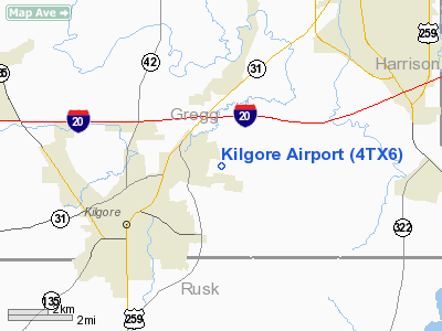
Location & QuickFacts
| FAA Information Effective: | 2008-09-25 |
| Airport Identifier: | 4TX6 |
| Airport Status: | Operational |
| Longitude/Latitude: | 094-49-05.7690W/32-24-45.5410N
-94.818269/32.412650 (Estimated) |
| Elevation: | 365 ft / 111.25 m (Estimated) |
| Land: | 140 acres |
| From nearest city: | 3 nautical miles NE of Kilgore, TX |
| Location: | Gregg County, TX |
| Magnetic Variation: | 05E (1985) |
Owner & Manager
| Ownership: | Privately owned |
| Owner: | Dana L Sneed |
| Address: | 3615 Norris Rd
Kilgore, TX 75662 |
| Phone number: | 903-984-4413 |
| Manager: | Dana L. Sneed |
| Address: | 3615 Norris Rd
Kilgore, TX 75662 |
| Phone number: | 903-984-4413 |
Airport Operations and Facilities
| Airport Use: | Private |
| Wind indicator: | Yes |
| Segmented Circle: | No |
| Control Tower: | No |
| Landing fee charge: | No |
| Sectional chart: | Memphis |
| Region: | ASW - Southwest |
| Boundary ARTCC: | ZFW - Fort Worth |
| Tie-in FSS: | FTW - Fort Worth |
| FSS on Airport: | No |
| FSS Phone: | 817-541-3474 |
| FSS Toll Free: | 1-800-WX-BRIEF |
Airport Services
| Airframe Repair: | MINOR |
| Power Plant Repair: | MINOR |
Runway Information
Runway 18/36
| Dimension: | 2780 x 50 ft / 847.3 x 15.2 m |
| Surface: | DIRT, |
| |
Runway 18 |
Runway 36 |
| Traffic Pattern: | Left | Left |
|
Radio Navigation Aids
| ID |
Type |
Name |
Ch |
Freq |
Var |
Dist |
| HNO | NDB | Henderson | | 371.00 | 06E | 13.7 nm |
| ABG | NDB | Ambassador | | 404.00 | 07E | 18.2 nm |
| RPF | NDB | Carthage | | 332.00 | 04E | 30.0 nm |
| LST | NDB | Lone Star | | 305.00 | 05E | 31.2 nm |
| TY | NDB | Tyler | | 320.00 | 06E | 33.1 nm |
| JSO | NDB | Cherokee County | | 263.00 | 05E | 38.4 nm |
| GXD | NDB | Nacogdoches | | 391.00 | 05E | 46.3 nm |
| CZJ | NDB | Amason | | 341.00 | 04E | 48.6 nm |
| VIV | NDB | Vivian | | 284.00 | 06E | 48.9 nm |
| TYR | VOR/DME | Tyler | 089X | 114.20 | 06E | 29.9 nm |
| UIM | VOR/DME | Quitman | 087X | 114.00 | 08E | 39.5 nm |
| FZT | VOR/DME | Frankston | 051X | 111.40 | 06E | 41.5 nm |
| GGG | VORTAC | Gregg County | 070X | 112.30 | 07E | 3.3 nm |
Remarks
- AIRPORT IN POOR CONDITION-LAND AT OWN RISK.
Images and information placed above are from
http://www.airport-data.com/airport/4TX6/
We thank them for the data!
| General Info
|
| Country |
United States
|
| State |
TEXAS
|
| FAA ID |
4TX6
|
| Latitude |
32-24-45.541N
|
| Longitude |
094-49-05.769W
|
| Elevation |
365 feet
|
| Near City |
KILGORE
|
We don't guarantee the information is fresh and accurate. The data may
be wrong or outdated.
For more up-to-date information please refer to other sources.
|
|


