 |
|
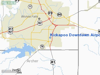
Kickapoo Downtown Airport |
| Kickapoo Downtown Airport |
| IATA: KIP – ICAO: KCWC – FAA LID: CWC |
| Summary |
| Airport type |
Public |
| Owner |
City of Wichita Falls |
| Serves |
Wichita Falls, Texas |
| Elevation AMSL |
1,003 ft / 306 m |
| Coordinates |
33°51′38″N 098°29′25″W / 33.86056°N 98.49028°W / 33.86056; -98.49028 |
| Runways |
| Direction |
Length |
Surface |
| ft |
m |
| 17/35 |
4,450 |
1,356 |
Concrete |
| Statistics (2008) |
| Aircraft operations |
22,400 |
| Based aircraft |
76 |
| Source: Federal Aviation Administration |
Kickapoo Downtown Airport (IATA: KIP, ICAO: KCWC, FAA LID: CWC, formerly T47) is a city-owned public use airport located three nautical miles (6 km) south of the central business district of Wichita Falls, a city in Wichita County, Texas, United States.
Although most U.S. airports use the same three-letter location identifier for the FAA and IATA, this airport is assigned CWC by the FAA and KIP by the IATA (which assigned CWC to Chernovtsy Airport in Chernovtsy, Ukraine).
Facilities and aircraft
Kickapoo Downtown Airport covers an area of 149 acres (60 ha) at an elevation of 1,003 feet (306 m) above mean sea level. It has one runway designated 17/35 with a concrete surface measuring 4,450 by 75 feet (1,356 x 23 m).
For the 12-month period ending August 12, 2008, the airport had 22,400 aircraft operations, an average of 61 per day: 99% general aviation and 1% air taxi. At that time there were 76 aircraft based at this airport: 64% single-engine, 29% multi-engine, 4% jet and 3% helicopter.
The above content comes from Wikipedia and is published under free licenses – click here to read more.
Location & QuickFacts
| FAA Information Effective: | 2008-09-25 |
| Airport Identifier: | CWC |
| Airport Status: | Operational |
| Longitude/Latitude: | 098-29-25.4350W/33-51-38.2200N
-98.490399/33.860617 (Estimated) |
| Elevation: | 1003 ft / 305.71 m (Surveyed) |
| Land: | 149 acres |
| From nearest city: | 3 nautical miles S of Wichita Falls, TX |
| Location: | Wichita County, TX |
| Magnetic Variation: | 08E (1980) |
Owner & Manager
| Ownership: | Publicly owned |
| Owner: | City Of Wichita Falls |
| Address: | 4515 Jacksboro Hwy
Wichita Falls, TX 76302 |
| Phone number: | 940-766-1735 |
| Manager: | Monica Morris
AIRPORT ADMINISTRATOR. |
| Address: | 4515 Jacksboro Hwy
Wichita Falls, TX 76302 |
| Phone number: | 940-766-1735 |
Airport Operations and Facilities
| Airport Use: | Open to public |
| Wind indicator: | Yes |
| Segmented Circle: | Yes |
| Control Tower: | No |
| Lighting Schedule: | DUSK-DAWN
ACTVT MIRL RY 17/35, PAPI RY 17, REIL RYS 17 & 35 - CTAF. |
| Beacon Color: | Clear-Green (lighted land airport) |
| Landing fee charge: | No |
| Sectional chart: | Dallas-ft Worth |
| Region: | ASW - Southwest |
| Traffic Pattern Alt: | 797 ft |
| Boundary ARTCC: | ZFW - Fort Worth |
| Tie-in FSS: | FTW - Fort Worth |
| FSS on Airport: | No |
| FSS Phone: | 817-541-3474 |
| FSS Toll Free: | 1-800-WX-BRIEF
LD TO FSS 855-5574. |
| NOTAMs Facility: | FTW (NOTAM-d service avaliable) |
| Federal Agreements: | NMY |
Airport Communications
| CTAF: | 122.700 |
| Unicom: | 122.700 |
Airport Services
| Fuel available: | 100LLA |
| Airframe Repair: | MAJOR |
| Power Plant Repair: | MAJOR |
| Bottled Oxygen: | NONE |
| Bulk Oxygen: | NONE |
Runway Information
Runway 17/35
| Dimension: | 4450 x 75 ft / 1356.4 x 22.9 m |
| Surface: | CONC, Good Condition |
| Weight Limit: | Single wheel: 30000 lbs. |
| Edge Lights: | Medium |
| |
Runway 17 |
Runway 35 |
| Longitude: | 098-29-25.3020W | 098-29-25.5721W |
| Latitude: | 33-52-00.2344N | 33-51-16.2160N |
| Elevation: | 979.00 ft | 1003.00 ft |
| Alignment: | 127 | 0 |
| Traffic Pattern: | Left | Left |
| Markings: | Non-precision instrument, Good Condition | Non-precision instrument, Good Condition |
| Crossing Height: | 37.00 ft | 41.00 ft |
| Displaced threshold: | 150.00 ft | 250.00 ft |
| VASI: | 4-light PAPI on left side | 4-light PAPI on left side |
| Visual Glide Angle: | 3.00° | 3.00° |
| Runway End Identifier: | Yes | Yes |
| Obstruction: | 12 ft road, 220.0 ft from runway, 1:1 slope to clear
APCH RATIO 16:1 AT DSPLCD THLD DUE TO AN 8 FT FENCE 135 FT FROM DSPLCD THLD, 210 FT TO THE LEFT OF CENTERLINE. | 15 ft road, 314.0 ft from runway, 7:1 slope to clear
APCH RATIO AT DSPLCD THLD 37:1 BASED ON 15 FT. ROAD, 564 FT FROM DSPLCD THLD ACROSS APCH . |
|
Radio Navigation Aids
| ID |
Type |
Name |
Ch |
Freq |
Var |
Dist |
| SKB | NDB | Scotland | | 344.00 | 08E | 4.2 nm |
| ONY | NDB | Olney | | 272.00 | 07E | 34.7 nm |
| GMZ | NDB | Grindstone Mountain | | 356.00 | 07E | 39.0 nm |
| GHX | NDB | Graham | | 371.00 | 07E | 41.8 nm |
| VRT | NDB | Wilbarger | | 230.00 | 08E | 45.0 nm |
| PFL | NDB | Post | | 308.00 | 08E | 45.2 nm |
| SHP | TACAN | Sheppard | 045X | | 10E | 7.3 nm |
| LAW | VOR/DME | Lawton | 031X | 109.40 | 09E | 38.4 nm |
| DUC | VOR/DME | Duncan | 047X | 111.00 | 09E | 42.5 nm |
| SPS | VORTAC | Wichita Falls | 074X | 112.70 | 10E | 9.2 nm |
| UKW | VORTAC | Bowie | 071X | 112.40 | 06E | 38.7 nm |
Remarks
- CAUTION: DO NOT MISTAKE KICKAPOO DOWNTOWN FOR SHEPPARD AFB/WICHITA FALLS MUNI ARPT 7 MILES NORTH.
- INTENSIVE JET TRAINER TFC 2300-3000 FT MSL WITHIN ALERT AREA A-636. REMAIN BLO 1800 FT MSL UNTIL IN RADAR CTC WITH APCH CTL FOR TFC ADVISORIES.
- ANTENNAS 2051 FT & 2047 FT MSL 3-5 MILES NW OF ARPT.
Images and information placed above are from
http://www.airport-data.com/airport/CWC/
We thank them for the data!
|
|


