 |
|
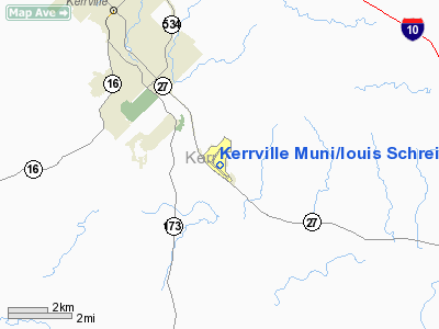
Kerrville Muni/louis Schreiner Field Airport |
Kerrville Municipal Airport
Louis Schreiner Field |
 |
| IATA: ERV – ICAO: KERV |
| Summary |
| Airport type |
City of Kerrville, Texas |
| Operator |
1616 |
| Location |
Kerrville, Texas |
| Elevation AMSL |
297 ft / m |
| Coordinates |
29°58′36.23″N 099°05′08.44″W / 29.9767306°N 99.0856778°W / 29.9767306; -99.0856778Coordinates: 29°58′36.23″N 099°05′08.44″W / 29.9767306°N 99.0856778°W / 29.9767306; -99.0856778 |
| Runways |
| Direction |
Length |
Surface |
| ft |
m |
| 12/30 |
6,000 |
1,829 |
Asphalt |
| 3/21 |
4,047 |
1,234 |
Asphalt |
Kerrville Municipal Airport (AKA Louis Schreiner Field) (IATA: ERV, ICAO: KERV) is a general aviation airport located 5 miles SE of Kerrville, Texas.
It is owned and operated by the city of Kerrville, Texas. History
The airport was opened in February 1943 as Louis Schreiner Field and was used by the United States Army Air Forces as a training base. At the end of the war the airfield was determined to be excess by the military and turned over to the local government for civil use.
The above content comes from Wikipedia and is published under free licenses – click here to read more.
Location & QuickFacts
| FAA Information Effective: | 2008-09-25 |
| Airport Identifier: | ERV |
| Airport Status: | Operational |
| Longitude/Latitude: | 099-05-07.7000W/29-58-36.0000N
-99.085472/29.976667 (Estimated) |
| Elevation: | 1617 ft / 492.86 m (Surveyed) |
| Land: | 528 acres |
| From nearest city: | 5 nautical miles SE of Kerrville, TX |
| Location: | Kerr County, TX |
| Magnetic Variation: | 06E (2005) |
Owner & Manager
| Ownership: | Publicly owned |
| Owner: | City Of Kerrville
AND KERR COUNTY JOINTLY |
| Address: | 800 Junction Hwy
Kerrville, TX 78028-5069 |
| Phone number: | 830-896-9399 |
| Manager: | Bruce Mckenzie
INTERIM AIRPORT MANAGER. |
| Address: | 800 Junction Hwy
Kerrville, TX 78028-5069 |
| Phone number: | 830-896-9399
FBO PHONE 830-257-8840. |
Airport Operations and Facilities
| Airport Use: | Open to public |
| Wind indicator: | Yes |
| Segmented Circle: | Yes |
| Control Tower: | No |
| Lighting Schedule: | DUSK-DAWN
MIRL RYS 03/21 & 12/30 PRESET LOW INTST; TO INCR INTST ACTVT - CTAF. |
| Beacon Color: | Clear-Green (lighted land airport) |
| Landing fee charge: | No |
| Sectional chart: | San Antonio |
| Region: | ASW - Southwest |
| Boundary ARTCC: | ZHU - Houston |
| Tie-in FSS: | SJT - San Angelo |
| FSS on Airport: | No |
| FSS Toll Free: | 1-800-WX-BRIEF |
| NOTAMs Facility: | ERV (NOTAM-d service avaliable) |
| Federal Agreements: | NGPY3 |
Airport Communications
| CTAF: | 122.700 |
| Unicom: | 122.700 |
Airport Services
| Fuel available: | 100LLA |
| Airframe Repair: | MAJOR |
| Power Plant Repair: | MAJOR |
| Bottled Oxygen: | HIGH |
Runway Information
Runway 03/21
| Dimension: | 3592 x 60 ft / 1094.8 x 18.3 m |
| Surface: | ASPH, Good Condition |
| Weight Limit: | Single wheel: 15000 lbs. |
| Edge Lights: | Medium |
| |
Runway 03 |
Runway 21 |
| Longitude: | 099-05-23.4554W | 099-05-01.2042W |
| Latitude: | 29-58-42.3929N | 29-59-12.2169N |
| Elevation: | 1579.00 ft | 1616.00 ft |
| Alignment: | 33 | 127 |
| Traffic Pattern: | Left | Left |
| Markings: | Basic, Good Condition | Basic, Good Condition |
| Crossing Height: | 25.00 ft | 25.00 ft |
| VASI: | 2-light PAPI on left side | 2-light PAPI on left side |
| Visual Glide Angle: | 3.50° | 3.50° |
| Obstruction: | 25 ft tree, 1450.0 ft from runway, 250 ft left of centerline, 50:1 slope to clear | 30 ft trees, 870.0 ft from runway, 240 ft left of centerline, 22:1 slope to clear |
|
Runway 12/30
| Dimension: | 6000 x 100 ft / 1828.8 x 30.5 m |
| Surface: | ASPH, Good Condition |
| Weight Limit: | Single wheel: 25000 lbs. |
| Edge Lights: | Medium |
| |
Runway 12 |
Runway 30 |
| Longitude: | 099-05-30.8011W | 099-04-38.9558W |
| Latitude: | 29-58-42.5904N | 29-58-03.9964N |
| Elevation: | 1573.00 ft | 1589.00 ft |
| Alignment: | 127 | 127 |
| ILS Type: | | LOCALIZER
|
| Traffic Pattern: | Left | Left |
| Markings: | Non-precision instrument, Good Condition | Non-precision instrument, Good Condition |
| Crossing Height: | 40.00 ft | 40.00 ft |
| Displaced threshold: | 690.00 ft | 0.00 ft |
| VASI: | 4-light PAPI on left side | 4-light PAPI on left side |
| Visual Glide Angle: | 2.83° | 2.83° |
| Obstruction: | 24 ft trees, 550.0 ft from runway, 250 ft left of centerline, 14:1 slope to clear
APCH SLOPE 50:1 FM DSPLCD THLD. | , 50:1 slope to clear |
|
Radio Navigation Aids
| ID |
Type |
Name |
Ch |
Freq |
Var |
Dist |
| ER | NDB | Shein | | 263.00 | 08E | 5.4 nm |
| HMA | NDB | Hondo | | 329.00 | 08E | 36.5 nm |
| CVB | NDB | Castroville | | 338.00 | 08E | 39.9 nm |
| KSY | TACAN | Kelly | 057X | | 07E | 43.9 nm |
| HDO | VOR/DME | Hondo | 31X | 109.40 | 08E | 38.0 nm |
| CSI | VORTAC | Center Point | 122X | 117.50 | 08E | 7.5 nm |
| STV | VORTAC | Stonewall | 085X | 113.80 | 08E | 24.1 nm |
| SAT | VORTAC | San Antonio | 115X | 116.80 | 08E | 38.2 nm |
| SAT | VOT | San Antonio Intl | | 110.40 | | 41.7 nm |
Remarks
- DEER ON & INVOF ARPT.
- PAEW ON ARPT.
Images and information placed above are from
http://www.airport-data.com/airport/ERV/
We thank them for the data!
| General Info
|
| Country |
United States
|
| State |
TEXAS
|
| FAA ID |
ERV
|
| Latitude |
29-58-36.246N
|
| Longitude |
099-05-08.447W
|
| Elevation |
1617 feet
|
| Near City |
KERRVILLE
|
We don't guarantee the information is fresh and accurate. The data may
be wrong or outdated.
For more up-to-date information please refer to other sources.
|
|


