 |
|
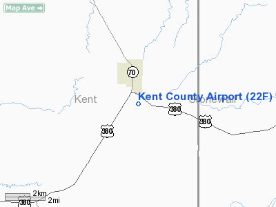
Location & QuickFacts
| FAA Information Effective: | 2008-09-25 |
| Airport Identifier: | 22F |
| Airport Status: | Operational |
| Longitude/Latitude: | 100-34-07.4120W/33-13-45.3360N
-100.568726/33.229260 (Estimated) |
| Elevation: | 2006 ft / 611.43 m (Estimated) |
| Land: | 60 acres |
| From nearest city: | 1 nautical miles S of Jayton, TX |
| Location: | Kent County, TX |
| Magnetic Variation: | 08E (1985) |
Owner & Manager
| Ownership: | Publicly owned |
| Owner: | Kent County |
| Address: | Kent Courthouse
Jayton, TX 79528 |
| Phone number: | 806-237-3373 |
| Manager: | Jim White
COUNTY JUDGE. |
| Address: | P.o. Box 6
Jayton, TX 79528 |
| Phone number: | 806-237-3373
EMERGENCY CONTACT PHONE: (806) 237-3801 (SHERIFF OFFICE) |
Airport Operations and Facilities
| Airport Use: | Open to public |
| Wind indicator: | Yes |
| Segmented Circle: | Yes |
| Control Tower: | No |
| Lighting Schedule: | DUSK-DAWN |
| Beacon Color: | Clear-Green (lighted land airport) |
| Landing fee charge: | No |
| Sectional chart: | Dallas-ft Worth |
| Region: | ASW - Southwest |
| Boundary ARTCC: | ZFW - Fort Worth |
| Tie-in FSS: | FTW - Fort Worth |
| FSS on Airport: | No |
| FSS Phone: | 817-541-3474 |
| FSS Toll Free: | 1-800-WX-BRIEF |
| NOTAMs Facility: | FTW (NOTAM-d service avaliable) |
Airport Communications
Airport Services
| Airframe Repair: | NONE |
| Power Plant Repair: | NONE |
| Bottled Oxygen: | NONE |
| Bulk Oxygen: | NONE |
Runway Information
Runway 17/35
| Dimension: | 3300 x 50 ft / 1005.8 x 15.2 m |
| Surface: | ASPH, Good Condition |
| Weight Limit: | Single wheel: 12500 lbs. |
| Edge Lights: | Low |
| |
Runway 17 |
Runway 35 |
| Traffic Pattern: | Left | Left |
| Markings: | Basic, Good Condition | Basic, Good Condition |
| Obstruction: | 22 ft road, 670.0 ft from runway, 170 ft left of centerline, 21:1 slope to clear | 32 ft trees, 810.0 ft from runway, 19:1 slope to clear |
|
Radio Navigation Aids
| ID |
Type |
Name |
Ch |
Freq |
Var |
Dist |
| SDR | NDB | Snyder | | 359.00 | 08E | 37.0 nm |
| CZX | NDB | Crosbyton | | 332.00 | 09E | 41.2 nm |
| AKL | NDB | Haskell | | 407.00 | 08E | 42.7 nm |
| SWW | NDB | Sweetwater | | 275.00 | 08E | 46.4 nm |
| TMV | NDB | Stamford | | 290.00 | 08E | 47.3 nm |
| GTH | VORTAC | Guthrie | 092X | 114.50 | 10E | 35.0 nm |
Remarks
- AGRICULTURAL ACTIVITY ON ARPT MAY-SEPT.
Images and information placed above are from
http://www.airport-data.com/airport/22F/
We thank them for the data!
| General Info
|
| Country |
United States
|
| State |
TEXAS
|
| FAA ID |
22F
|
| Latitude |
33-13-45.336N
|
| Longitude |
100-34-07.412W
|
| Elevation |
2006 feet
|
| Near City |
JAYTON
|
We don't guarantee the information is fresh and accurate. The data may
be wrong or outdated.
For more up-to-date information please refer to other sources.
|
|


