 |
|
| Kenneth Copeland Airport |
| IATA: none – ICAO: none – FAA LID: 4T2 |
| Summary |
| Airport type |
Public |
| Location |
Fort Worth, Texas |
| Elevation AMSL |
688 ft / 209.7 m |
| Coordinates |
32°58′38″N 097°29′18″W / 32.97722°N 97.48833°W / 32.97722; -97.48833Coordinates: 32°58′38″N 097°29′18″W / 32.97722°N 97.48833°W / 32.97722; -97.48833 |
| Runways |
| Direction |
Length |
Surface |
| ft |
m |
| 17/35 |
6,000 |
1,829 |
Concrete |
| 12/30 |
3,000 |
914 |
Asphalt |
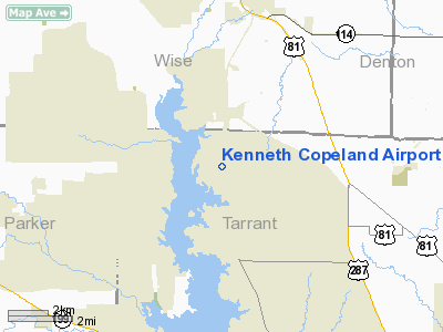
Kenneth Copeland Airport (FAA LID: 4T2) is a private airport located eighteen miles (29 km) northwest of the central business district (CBD) of Fort Worth, in Tarrant County, Texas, USA.[1]
The airport is used solely for general aviation purposes, mainly those of the airport's namesake, televangelist Kenneth Copeland (whose ministry is located near the airport).
Facilities
Kenneth Copeland Airport has two runways:
- Runway 17/35: 6,000 x 125 ft. (1,829 x 38 m), Surface: Concrete
- Runway 12/30: 3,000 x 125 ft. (914 x 38 m), Surface: Asphalt
The above content comes from Wikipedia and is published under free licenses – click here to read more.
Location & QuickFacts
| FAA Information Effective: | 2008-09-25 |
| Airport Identifier: | 4T2 |
| Airport Status: | Operational |
| Longitude/Latitude: | 097-29-18.0760W/32-58-38.4490N
-97.488354/32.977347 (Estimated) |
| Elevation: | 688 ft / 209.70 m (Surveyed) |
| Land: | 0 acres |
| From nearest city: | 18 nautical miles NW of Fort Worth, TX |
| Location: | Tarrant County, TX |
| Magnetic Variation: | 07E (1985) |
Owner & Manager
| Ownership: | Privately owned |
| Owner: | Ken Copeland Ministries |
| Address: | Po Box 446
Newark, TX 76071 |
| Phone number: | 817-489-3730 |
| Manager: | Wayne Coleman |
| Address: | Po Box 446
Newark, TX 76071 |
| Phone number: | 817-489-2051 |
Airport Operations and Facilities
| Airport Use: | Open to public |
| Wind indicator: | Yes |
| Segmented Circle: | No |
| Control Tower: | No |
| Lighting Schedule: | DUSK-DAWN
ACTVT MIRL RY 12/30 & LIRL RY 17/35 - CTAF. |
| Beacon Color: | Clear-Green (lighted land airport) |
| Landing fee charge: | No |
| Sectional chart: | Dallas-ft Worth |
| Region: | ASW - Southwest |
| Boundary ARTCC: | ZFW - Fort Worth |
| Tie-in FSS: | FTW - Fort Worth |
| FSS on Airport: | No |
| FSS Phone: | 817-541-3474 |
| FSS Toll Free: | 1-800-WX-BRIEF |
| NOTAMs Facility: | FTW (NOTAM-d service avaliable) |
Airport Communications
| CTAF: | 123.075 |
| Unicom: | 123.075 |
Runway Information
Runway 12/30
| Dimension: | 3000 x 75 ft / 914.4 x 22.9 m |
| Surface: | ASPH-CONC, Fair Condition
OUTER 18 FT OF EACH SIDE OF RY IS ASPH, CENTER 39 FT IS CONC.
OUTER 50 FT OF EACH SIDE OF RY IS ASPH, CENTER 40 FT IS CONC ON RY 17 END; ASPH ON RY 35 END. |
| Edge Lights: | Medium |
| |
Runway 12 |
Runway 30 |
| Traffic Pattern: | Left | Left |
| Markings: | Non-precision instrument, | Basic, |
| Obstruction: | 5 ft fence, 200.0 ft from runway
ROAD 29 FT FM END OF RY 0B 10 FT HIGH. | 5 ft fence, 326.0 ft from runway, 25:1 slope to clear
ROAD 56 FT FM RY END 0B 10 FT HIGH. |
|
Runway 17/35
| Dimension: | 6000 x 140 ft / 1828.8 x 42.7 m |
| Surface: | ASPH-CONC, Fair Condition
OUTER 18 FT OF EACH SIDE OF RY IS ASPH, CENTER 39 FT IS CONC.
OUTER 50 FT OF EACH SIDE OF RY IS ASPH, CENTER 40 FT IS CONC ON RY 17 END; ASPH ON RY 35 END. |
| Edge Lights: | Low |
| |
Runway 17 |
Runway 35 |
| Traffic Pattern: | Left | Left |
| Markings: | Non-precision instrument, Fair Condition | Non-precision instrument, Fair Condition |
|
Radio Navigation Aids
| ID |
Type |
Name |
Ch |
Freq |
Var |
Dist |
| MWL | NDB | Mineral Wells | | 266.00 | 06E | 31.0 nm |
| XQH | NDB | Cedar Hill | | 353.00 | 08E | 34.8 nm |
| RBD | NDB | Redbird | | 287.00 | 06E | 36.0 nm |
| GMZ | NDB | Grindstone Mountain | | 356.00 | 07E | 40.4 nm |
| LNC | NDB | Lancaster | | 239.00 | 06E | 45.6 nm |
| GZV | NDB | Brazos River | | 280.00 | 07E | 46.7 nm |
| GLE | NDB | Gainesville | | 330.00 | 06E | 46.9 nm |
| PQF | NDB | Mesquite | | 248.00 | 06E | 49.5 nm |
| NFW | TACAN | Nas Jrb Fort Worth | 024X | | 07E | 12.6 nm |
| TTT | VOR/DME | Maverick | 078X | 113.10 | 06E | 23.5 nm |
| CVE | VOR/DME | Cowboy | 109X | 116.20 | 06E | 29.9 nm |
| FUZ | VORTAC | Ranger | 104X | 115.70 | 06E | 16.5 nm |
| MQP | VORTAC | Millsap | 124X | 117.70 | 09E | 29.8 nm |
| UKW | VORTAC | Bowie | 071X | 112.40 | 06E | 37.5 nm |
| FTW | VOT | Fort Worth Meacham | | 108.20 | | 11.6 nm |
| DAL | VOT | Dallas Love Field | | 113.30 | | 33.1 nm |
Images and information placed above are from
http://www.airport-data.com/airport/4T2/
We thank them for the data!
| General Info
|
| Country |
United States
|
| State |
TEXAS
|
| FAA ID |
4T2
|
| Latitude |
32.977348
32° 58' 38.45" N
|
| Longitude |
-97.488356
097° 29' 18.08" W
|
| Elevation |
688 feet
210 meters
|
| Magnetic Variation |
005° E (01/06)
|
| Beacon |
Yes
|
| Operating Agency |
PRIVATE
|
| Daylight Saving Time |
Second Sunday in March at 0200 to first Sunday in November at 0200 local time (Exception Arizona and that portion of Indiana in the Eastern Time Zone)
|
We don't guarantee the information is fresh and accurate. The data may
be wrong or outdated.
For more up-to-date information please refer to other sources.
|
|


