 |
|
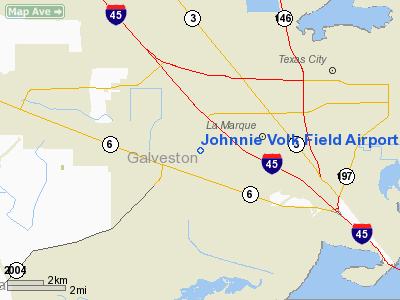
Johnnie Volk Field Airport |
Location & QuickFacts
| FAA Information Effective: | 2008-09-25 |
| Airport Identifier: | 37TE |
| Airport Status: | Operational |
| Longitude/Latitude: | 095-00-35.7320W/29-21-36.8430N
-95.009926/29.360234 (Estimated) |
| Elevation: | 13 ft / 3.96 m (Estimated) |
| Land: | 30 acres |
| From nearest city: | 1 nautical miles NE of Hitchcock, TX |
| Location: | Galveston County, TX |
| Magnetic Variation: | 06E (1985) |
Owner & Manager
| Ownership: | Privately owned |
| Owner: | M. E. Leonard, Sr. |
| Address: | Box 6202 Fm 519
Hitchcock, TX 77563 |
| Phone number: | 713-986-6006 |
| Manager: | M. E. Leonard, Sr. |
| Address: | Box 6202 Fm 519
Hitchcock, TX 77563 |
| Phone number: | 713-986-6006 |
Airport Operations and Facilities
| Airport Use: | Private |
| Wind indicator: | Yes |
| Segmented Circle: | No |
| Control Tower: | No |
| Landing fee charge: | No |
| Sectional chart: | Houston |
| Region: | ASW - Southwest |
| Boundary ARTCC: | ZHU - Houston |
| Tie-in FSS: | CXO - Montgomery County |
| FSS on Airport: | No |
| FSS Toll Free: | 1-800-WX-BRIEF
FOR FP FILING CALL CXO FSS 1-800-833-5602. |
Airport Services
| Airframe Repair: | NONE |
| Power Plant Repair: | NONE |
Runway Information
Runway 16/34
| Dimension: | 2700 x 60 ft / 823.0 x 18.3 m |
| Surface: | TURF, Fair Condition
& RWY 17/35 VERY SOFT WHEN WET. |
| |
Runway 16 |
Runway 34 |
| Traffic Pattern: | Left | Left |
| Obstruction: | 20 ft trees | 20 ft trees, 0.0 ft from runway, 50 ft right of centerline |
|
Runway 17/35
| Dimension: | 2130 x 100 ft / 649.2 x 30.5 m |
| Surface: | TURF, Fair Condition
& RWY 17/35 VERY SOFT WHEN WET. |
| |
Runway 17 |
Runway 35 |
| Traffic Pattern: | Left | Left |
| Obstruction: | 20 ft trees | 25 ft pline, 120.0 ft from runway, 4:1 slope to clear |
|
Radio Navigation Aids
| ID |
Type |
Name |
Ch |
Freq |
Var |
Dist |
| GLS | NDB | Galveston | | 206.00 | 08E | 13.4 nm |
| JPA | NDB | Sanjac | | 347.00 | 05E | 18.8 nm |
| SYG | NDB | Sandy Point | | 402.00 | 05E | 25.5 nm |
| CBC | NDB | Anahuac | | 413.00 | 05E | 30.7 nm |
| SGR | NDB | Hull | | 388.00 | 05E | 37.6 nm |
| BVP | NDB | Nixin | | 326.00 | 05E | 39.5 nm |
| LYD | NDB | Lakeside | | 249.00 | 05E | 44.4 nm |
| EYQ | NDB | Weiser | | 286.00 | 06E | 47.7 nm |
| EFD | TACAN | Ellington | 031X | | 05E | 16.7 nm |
| MHF | VOR/DME | Trinity | 083X | 113.60 | 07E | 17.7 nm |
| HUB | VOR/DME | Hobby | 118X | 117.10 | 05E | 22.6 nm |
| VUH | VORTAC | Scholes | 077X | 113.00 | 06E | 9.2 nm |
| IAH | VORTAC | Humble | 113X | 116.60 | 05E | 39.9 nm |
| HOU | VOT | Houston Wm P Hobby | | 108.40 | | 22.2 nm |
Remarks
- VFR USE ONLY;RWYS ARE DISPLACED TO PROVIDE 20:1 VERTICAL CLEARANCE AS DEFINED IN FAR PART 77.
Images and information placed above are from
http://www.airport-data.com/airport/37TE/
We thank them for the data!
| General Info
|
| Country |
United States
|
| State |
TEXAS
|
| FAA ID |
37TE
|
| Latitude |
29-21-36.843N
|
| Longitude |
095-00-35.732W
|
| Elevation |
13 feet
|
| Near City |
HITCHCOCK
|
We don't guarantee the information is fresh and accurate. The data may
be wrong or outdated.
For more up-to-date information please refer to other sources.
|
|


