 |
|
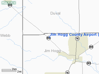
Location & QuickFacts
| FAA Information Effective: | 2008-09-25 |
| Airport Identifier: | HBV |
| Airport Status: | Operational |
| Longitude/Latitude: | 098-44-13.0000W/27-20-58.4000N
-98.736944/27.349556 (Estimated) |
| Elevation: | 663 ft / 202.08 m (Surveyed) |
| Land: | 93 acres |
| From nearest city: | 3 nautical miles NW of Hebbronville, TX |
| Location: | Jim Hogg County, TX |
| Magnetic Variation: | 06E (2000) |
Owner & Manager
| Ownership: | Publicly owned |
| Owner: | Jim Hogg County |
| Address: | Agapito Molina Jr
Hebbronville, TX 78361 |
| Phone number: | 361-527-3015 |
| Manager: | Richard Almaraz |
| Address: | Po Box 729
Hebbronville, TX 78361 |
| Phone number: | 361-527-9033
OR 361-527-3250, OR 361-527-5805. |
Airport Operations and Facilities
| Airport Use: | Open to public |
| Wind indicator: | Yes |
| Segmented Circle: | Yes |
| Control Tower: | No |
| Lighting Schedule: | DUSK-DAWN
MIRL RY 13/31 PRESET LOW INTST; TO INCR INTST ACTVT - CTAF. |
| Beacon Color: | Clear-Green (lighted land airport) |
| Landing fee charge: | No |
| Sectional chart: | Brownsville |
| Region: | ASW - Southwest |
| Boundary ARTCC: | ZHU - Houston |
| Tie-in FSS: | SJT - San Angelo |
| FSS on Airport: | No |
| FSS Toll Free: | 1-800-WX-BRIEF |
| NOTAMs Facility: | HBV (NOTAM-d service avaliable) |
| Federal Agreements: | NGY |
Airport Communications
| CTAF: | 122.800 |
| Unicom: | 122.800 |
Airport Services
| Fuel available: | A |
| Airframe Repair: | NONE |
| Power Plant Repair: | NONE |
Runway Information
Runway 13/31
| Dimension: | 5003 x 75 ft / 1524.9 x 22.9 m |
| Surface: | ASPH, Good Condition |
| Weight Limit: | Single wheel: 30000 lbs.
Dual wheel: 72000 lbs.
GWT PAVEMENT STRENGTH PRVDD BY ARPT MGR. |
| Edge Lights: | Medium |
| |
Runway 13 |
Runway 31 |
| Longitude: | 098-44-32.9169W | 098-43-53.1676W |
| Latitude: | 27-21-15.6944N | 27-20-41.1315N |
| Elevation: | 661.00 ft | 663.00 ft |
| Alignment: | 127 | 127 |
| Traffic Pattern: | Left | Left |
| Markings: | Non-precision instrument, Good Condition | Non-precision instrument, Good Condition |
| Obstruction: | 8 ft brush, 440.0 ft from runway, 225 ft right of centerline, 30:1 slope to clear | 7 ft brush, 344.0 ft from runway, 240L/ ft right of centerline, 20:1 slope to clear |
|
Radio Navigation Aids
| ID |
Type |
Name |
Ch |
Freq |
Var |
Dist |
| HBV | NDB | Hebbronville | | 266.00 | 06E | 0.5 nm |
| BKS | NDB | Brooks County | | 353.00 | 06E | 34.0 nm |
| TKB | NDB | Kleberg County | | 347.00 | 06E | 38.0 nm |
| SNE | NDB | Santa Elena | | 260.00 | 07E | 38.9 nm |
| NOG | TACAN | Orange Grove | 063X | | 09E | 49.4 nm |
| ALI | VOR | Alice | | 114.50 | 06E | 44.8 nm |
| NLD | VOR/DME | Nuevo Laredo | 073X | 112.60 | 09E | 44.6 nm |
| LRD | VORTAC | Laredo | 121X | 117.40 | 09E | 37.1 nm |
Images and information placed above are from
http://www.airport-data.com/airport/HBV/
We thank them for the data!
| General Info
|
| Country |
United States
|
| State |
TEXAS
|
| FAA ID |
HBV
|
| Latitude |
27-20-58.400N
|
| Longitude |
098-44-13.100W
|
| Elevation |
663 feet
|
| Near City |
HEBBRONVILLE
|
We don't guarantee the information is fresh and accurate. The data may
be wrong or outdated.
For more up-to-date information please refer to other sources.
|
|


