 |
|
| Horizon Airport |
| IATA: none – ICAO: none – FAA LID: 74R |
| Summary |
| Airport type |
Public |
| Owner |
Toudouze Investments, Inc. |
| Location |
San Antonio, Texas |
| Elevation AMSL |
550 ft / 168 m |
| Coordinates |
29°17′01″N 098°30′01″W / 29.28361°N 98.50028°W / 29.28361; -98.50028 |
| Runways |
| Direction |
Length |
Surface |
| ft |
m |
| 11/29 |
2,360 |
719 |
Turf |
| 16/34 |
2,250 |
686 |
Turf |
| Statistics (2004) |
| Aircraft operations |
2,800 |
| Source: Federal Aviation Administration |
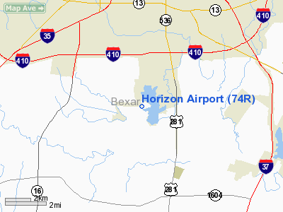
Horizon Airport (FAA LID: 74R) is a public-use airport located nine miles (14 km) south of the central business district of San Antonio, a city in Bexar County, Texas, United States. It is privately owned by Toudouze Investments, Inc.
Facilities and aircraft
Horizon Airport covers an area of 107 acres (43 ha) which contains two runways:
- Runway 11/29: 2,360 x 80 ft (719 x 24 m), Surface: Turf
- Runway 16/34: 2,250 x 100 ft (686 x 30 m), Surface: Turf
For the 12-month period ending January 28, 2004, the airport had 2,800 aircraft operations, 100% of which were general aviation.
The above content comes from Wikipedia and is published under free licenses – click here to read more.
| Horizon Airport |
| IATA: none – ICAO: none – FAA LID: T27 |
| Summary |
| Airport type |
Public |
| Owner |
Family of Phil Barrett |
| Location |
El Paso, Texas |
| Elevation AMSL |
4,007 ft / 1,221 m |
| Coordinates |
31°43′11″N 106°14′13″W / 31.71972°N 106.23694°W / 31.71972; -106.23694 |
| Runways |
| Direction |
Length |
Surface |
| ft |
m |
| 8/26 |
6,885 |
2,099 |
Asphalt/Dirt |
| Statistics (2007) |
| Aircraft operations |
31,200 |
| Based aircraft |
90 |
| Source: Federal Aviation Administration |
Horizon Airport (FAA LID: T27) is a public-use airport in El Paso, Texas, located 11 miles (18 km) southeast of the central business district on Pellicano Drive about 1.5 miles east of Joe Battle Boulevard (Texas Loop 375). It is privately owned by the family of the late Phil Barrett .
Facilities and aircraft
Horizon Airport covers an area of 200 acres (81 ha) which contains one runway:
- Runway 8/26: 6,885 x 50 ft (2,099 x 15 m), Surface: 6,885 ft Asphalt / 2,500 ft Dirt
For the 12-month period ending April 28, 2007, the airport had 31,200 aircraft operations, an average of 85 per day, 100% of which were general aviation. There are 90 aircraft based at this airport: 76% single engine, 2% multi-engine, 11% gliders and 11% ultralights.
Horizon Airport is home to the local soaring society for gliders. It has previously hosted 1/4 mile drag racing events and features a cement launch pad and paved staging area.
The above content comes from Wikipedia and is published under free licenses – click here to read more.
Location & QuickFacts
| FAA Information Effective: | 2008-09-25 |
| Airport Identifier: | 74R |
| Airport Status: | Operational |
| Longitude/Latitude: | 098-30-01.0580W/29-17-00.8560N
-98.500294/29.283571 (Estimated) |
| Elevation: | 550 ft / 167.64 m (Estimated) |
| Land: | 107 acres |
| From nearest city: | 9 nautical miles S of San Antonio, TX |
| Location: | Bexar County, TX |
| Magnetic Variation: | 07E (1985) |
Owner & Manager
| Ownership: | Privately owned |
| Owner: | Toudouze Investments Inc
MANAGING PARTNER WILLIAM S. TOUDOUZE. |
| Address: | 3714 Litchfield
San Antonio, TX 78230 |
| Phone number: | 210-696-1663 |
| Manager: | Rusty Henley |
| Address: | 13680 Pleasanton
San Antonio, TX 78219 |
| Phone number: | 210-744-5683
PAGE NR MGR HOME PHONE 210-633-2372. |
Airport Operations and Facilities
| Airport Use: | Open to public |
| Wind indicator: | Yes |
| Segmented Circle: | No |
| Control Tower: | No |
| Landing fee charge: | No |
| Sectional chart: | San Antonio |
| Region: | ASW - Southwest |
| Boundary ARTCC: | ZHU - Houston |
| Tie-in FSS: | SJT - San Angelo |
| FSS on Airport: | No |
| FSS Toll Free: | 1-800-WX-BRIEF
FOR LOCAL CALL TO FSS 826-9561. |
| NOTAMs Facility: | SJT (NOTAM-d service avaliable) |
Airport Communications
Airport Services
| Bottled Oxygen: | NONE |
| Bulk Oxygen: | NONE |
Runway Information
Runway 11/29
| Dimension: | 2360 x 80 ft / 719.3 x 24.4 m |
| Surface: | TURF, Good Condition |
| |
Runway 11 |
Runway 29 |
| Traffic Pattern: | Left | Left |
| Obstruction: | 5 ft fence, 47 ft right of centerline | 20 ft trees, 0.0 ft from runway, 100 ft left of centerline |
|
Runway 16/34
| Dimension: | 2250 x 100 ft / 685.8 x 30.5 m |
| Surface: | TURF, Good Condition |
| |
Runway 16 |
Runway 34 |
| Traffic Pattern: | Left | Left |
| Obstruction: | 15 ft brush, 90 ft left of centerline | 25 ft tree, 0.0 ft from runway, 100 ft right of centerline |
|
Radio Navigation Aids
| ID |
Type |
Name |
Ch |
Freq |
Var |
Dist |
| CVB | NDB | Castroville | | 338.00 | 08E | 18.7 nm |
| PEZ | NDB | Pleasanton | | 275.00 | 07E | 19.8 nm |
| HHH | NDB | Devine | | 359.00 | 07E | 24.6 nm |
| HMA | NDB | Hondo | | 329.00 | 08E | 35.6 nm |
| ER | NDB | Shein | | 263.00 | 08E | 46.4 nm |
| KSY | TACAN | Kelly | 057X | | 07E | 7.7 nm |
| DHK | TACAN | Randolph | 036X | | 09E | 19.5 nm |
| SSF | VOR | Stinson | | 108.40 | 09E | 3.3 nm |
| HDO | VOR/DME | Hondo | 31X | 109.40 | 08E | 35.7 nm |
| RND | VORTAC | Randolph | 70X | 112.30 | 09E | 18.1 nm |
| SAT | VORTAC | San Antonio | 115X | 116.80 | 08E | 21.8 nm |
| SAT | VOT | San Antonio Intl | | 110.40 | | 15.1 nm |
Remarks
Images and information placed above are from
http://www.airport-data.com/airport/74R/
We thank them for the data!
| General Info
|
| Country |
United States
|
| State |
TEXAS
|
| FAA ID |
T27
|
| Latitude |
31-43-10.900N
|
| Longitude |
106-14-21.430W
|
| Elevation |
4007 feet
|
| Near City |
EL PASO
|
We don't guarantee the information is fresh and accurate. The data may
be wrong or outdated.
For more up-to-date information please refer to other sources.
|
|


