 |
|
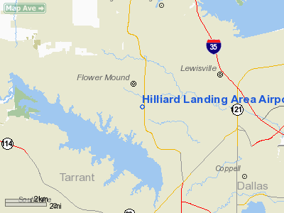
Hilliard Landing Area Airport |
Location & QuickFacts
| FAA Information Effective: | 2008-09-25 |
| Airport Identifier: | 5TX6 |
| Airport Status: | Operational |
| Longitude/Latitude: | 097-04-21.0350W/33-01-00.4420N
-97.072510/33.016789 (Estimated) |
| Elevation: | 635 ft / 193.55 m (Estimated) |
| Land: | 0 acres |
| From nearest city: | 4 nautical miles SW of Lewisville, TX |
| Location: | Denton County, TX |
| Magnetic Variation: | 07E (1985) |
Owner & Manager
| Ownership: | Privately owned |
| Owner: | Ernest F Hilliard |
| Address: | 1500 Long Praire
Flowery Mound, TX 75028 |
| Phone number: | 214-539-0691 |
| Address: |
|
Airport Operations and Facilities
| Airport Use: | Private |
| Wind indicator: | Yes |
| Segmented Circle: | No |
| Control Tower: | No |
| Landing fee charge: | No |
| Sectional chart: | Dallas-ft Worth |
| Region: | ASW - Southwest |
| Boundary ARTCC: | ZFW - Fort Worth |
| Tie-in FSS: | FTW - Fort Worth |
| FSS on Airport: | No |
| FSS Phone: | 817-541-3474 |
| FSS Toll Free: | 1-800-WX-BRIEF |
Runway Information
Runway 16/34
| Dimension: | 1900 x 100 ft / 579.1 x 30.5 m |
| Surface: | TURF, |
| |
Runway 16 |
Runway 34 |
| Traffic Pattern: | Left | Left |
|
Radio Navigation Aids
| ID |
Type |
Name |
Ch |
Freq |
Var |
Dist |
| RBD | NDB | Redbird | | 287.00 | 06E | 22.8 nm |
| XQH | NDB | Cedar Hill | | 353.00 | 08E | 26.0 nm |
| PQF | NDB | Mesquite | | 248.00 | 06E | 30.1 nm |
| LNC | NDB | Lancaster | | 239.00 | 06E | 31.8 nm |
| JUG | NDB | Jecca | | 388.00 | 06E | 34.4 nm |
| MII | NDB | Caddo Mills | | 316.00 | 06E | 41.5 nm |
| GLE | NDB | Gainesville | | 330.00 | 06E | 42.7 nm |
| AVZ | NDB | Travis | | 260.00 | 06E | 44.3 nm |
| GMZ | NDB | Grindstone Mountain | | 356.00 | 07E | 49.9 nm |
| NFW | TACAN | Nas Jrb Fort Worth | 024X | | 07E | 23.7 nm |
| TTT | VOR/DME | Maverick | 078X | 113.10 | 06E | 9.0 nm |
| CVE | VOR/DME | Cowboy | 109X | 116.20 | 06E | 11.4 nm |
| FUZ | VORTAC | Ranger | 104X | 115.70 | 06E | 9.4 nm |
| UKW | VORTAC | Bowie | 071X | 112.40 | 06E | 48.9 nm |
| MQP | VORTAC | Millsap | 124X | 117.70 | 09E | 49.9 nm |
| DAL | VOT | Dallas Love Field | | 113.30 | | 15.1 nm |
| FTW | VOT | Fort Worth Meacham | | 108.20 | | 18.7 nm |
Remarks
- IN CLOSE PROX TO DFW REG ARPT; COMPATIBLE TFC PATS W/BLACK MRK LNDG AREA HAS TO BE ESTAB; NOISE PROB W/HOUSING DEV.
Images and information placed above are from
http://www.airport-data.com/airport/5TX6/
We thank them for the data!
| General Info
|
| Country |
United States
|
| State |
TEXAS
|
| FAA ID |
5TX6
|
| Latitude |
33-01-00.442N
|
| Longitude |
097-04-21.035W
|
| Elevation |
635 feet
|
| Near City |
LEWISVILLE
|
We don't guarantee the information is fresh and accurate. The data may
be wrong or outdated.
For more up-to-date information please refer to other sources.
|
|


