 |
|
| Happy Landings Airport |
| IATA: none – ICAO: none – FAA LID: 2H5 |
| Summary |
| Airport type |
Public |
| Owner |
John D. Hull, Jr. & Mary Hull |
| Serves |
Houston, Texas |
| Location |
Beasley, Texas |
| Elevation AMSL |
105 ft / 32 m |
| Coordinates |
29°30′18″N 095°54′00″W / 29.505°N 95.9°W / 29.505; -95.9 |
| Runways |
| Direction |
Length |
Surface |
| ft |
m |
| 17/35 |
4,400 |
1,341 |
Turf |
| Source: Federal Aviation Administration |
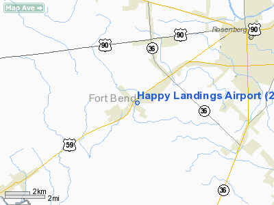
Happy Landings Airport (FAA LID: 2H5) is a public-use airport located in unincorporated Fort Bend County, Texas, United States. The airport is located east of Beasley and 33 nautical miles (61 km) southwest of the central business district of Houston. It is privately owned by John D. Hull, Jr. and Mary Hull.
Facilities
Happy Landings Airport covers an area of 350 acres (142 ha) at an elevation of 105 feet (32 m) above mean sea level. It has one runway designated 17/35 with a turf surface measuring 4,400 by 100 feet (1,341 x 30 m).
The above content comes from Wikipedia and is published under free licenses – click here to read more.
Location & QuickFacts
| FAA Information Effective: | 2008-09-25 |
| Airport Identifier: | 2H5 |
| Airport Status: | Operational |
| Longitude/Latitude: | 095-54-00.3000W/29-30-17.7000N
-95.900083/29.504917 (Estimated) |
| Elevation: | 105 ft / 32.00 m (Estimated) |
| Land: | 350 acres |
| From nearest city: | 33 nautical miles SW of Houston, TX |
| Location: | Fort Bend County, TX |
| Magnetic Variation: | () |
Owner & Manager
| Ownership: | Privately owned |
| Owner: | John D. Hull, Jr & Mary Hull |
| Address: | 7811 Dashwood
Houston, TX 77036 |
| Phone number: | 713-772-0083 |
| Manager: | John Hull, Jr |
| Address: | 7811 Dashwood
Houston, TX 77036 |
| Phone number: | 713-772-0083 |
Airport Operations and Facilities
| Airport Use: | Open to public |
| Segmented Circle: | No |
| Control Tower: | No |
| Sectional chart: | Houston |
| Region: | ASW - Southwest |
| Boundary ARTCC: | ZHU - Houston |
| Tie-in FSS: | CXO - Montgomery County |
| FSS Toll Free: | 1-800-WX-BRIEF |
| NOTAMs Facility: | CXO (NOTAM-d service avaliable) |
Airport Communications
Runway Information
Runway 17/35
| Dimension: | 4400 x 100 ft / 1341.1 x 30.5 m |
| Surface: | TURF, |
| |
Runway 17 |
Runway 35 |
| Alignment: | 127 | 127 |
| Traffic Pattern: | Left | Left |
| Obstruction: | 30 ft trees, 25.0 ft from runway | 2 ft fence, 12.0 ft from runway, 125 ft right of centerline, 6:1 slope to clear |
|
Radio Navigation Aids
| ID |
Type |
Name |
Ch |
Freq |
Var |
Dist |
| SGR | NDB | Hull | | 388.00 | 05E | 14.9 nm |
| ARM | NDB | Wharton | | 245.00 | 06E | 20.0 nm |
| LYD | NDB | Lakeside | | 249.00 | 05E | 22.0 nm |
| SYG | NDB | Sandy Point | | 402.00 | 05E | 22.6 nm |
| EYQ | NDB | Weiser | | 286.00 | 06E | 29.1 nm |
| BYY | NDB | Bay City | | 344.00 | 06E | 32.1 nm |
| DWH | NDB | David Hooks | | 521.00 | 05E | 41.2 nm |
| JPA | NDB | Sanjac | | 347.00 | 05E | 44.5 nm |
| BVP | NDB | Nixin | | 326.00 | 05E | 46.3 nm |
| BNH | NDB | Brenham | | 362.00 | 06E | 49.7 nm |
| EFD | TACAN | Ellington | 031X | | 05E | 39.2 nm |
| ELA | VOR/DME | Eagle Lake | 111X | 116.40 | 08E | 23.8 nm |
| HUB | VOR/DME | Hobby | 118X | 117.10 | 05E | 33.8 nm |
| IAH | VORTAC | Humble | 113X | 116.60 | 05E | 39.7 nm |
| IDU | VORTAC | Industry | 039X | 110.20 | 08E | 43.9 nm |
| TNV | VORTAC | Navasota | 106X | 115.90 | 08E | 47.8 nm |
| PSX | VORTAC | Palacios | 120X | 117.30 | 08E | 49.4 nm |
| HOU | VOT | Houston Wm P Hobby | | 108.40 | | 33.6 nm |
Images and information placed above are from
http://www.airport-data.com/airport/2H5/
We thank them for the data!
|
|


