 |
|
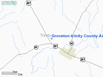
Groveton-trinity County Airport |
Location & QuickFacts
| FAA Information Effective: | 2008-09-25 |
| Airport Identifier: | 33R |
| Airport Status: | Operational |
| Longitude/Latitude: | 095-09-50.7710W/31-05-05.6630N
-95.164103/31.084906 (Estimated) |
| Elevation: | 340 ft / 103.63 m (Estimated) |
| Land: | 77 acres |
| From nearest city: | 3 nautical miles NW of Groveton, TX |
| Location: | Trinity County, TX |
| Magnetic Variation: | 06E (1985) |
Owner & Manager
| Ownership: | Publicly owned |
| Owner: | Groveton-trinity County |
| Address: | Trinity Co Court House
Groveton, TX 75845 |
| Phone number: | 936-642-1746 |
| Manager: | Mark Evans (co Judge) |
| Address: | Box 457
Groveton, TX 75845 |
| Phone number: | 936-642-1746 |
Airport Operations and Facilities
| Airport Use: | Open to public |
| Wind indicator: | Yes |
| Segmented Circle: | Yes |
| Control Tower: | No |
| Lighting Schedule: | DUSK-DAWN
ACTVT LIRL RY 16/34 - CTAF. |
| Beacon Color: | Clear-Green (lighted land airport) |
| Landing fee charge: | No |
| Sectional chart: | Houston |
| Region: | ASW - Southwest |
| Boundary ARTCC: | ZHU - Houston |
| Tie-in FSS: | CXO - Montgomery County |
| FSS on Airport: | No |
| FSS Toll Free: | 1-800-WX-BRIEF
FOR FP FILING CALL CXO FSS 1-800-833-5602 |
| NOTAMs Facility: | CXO (NOTAM-d service avaliable) |
| Federal Agreements: | SY |
Airport Communications
Airport Services
| Airframe Repair: | NONE |
| Power Plant Repair: | NONE |
| Bottled Oxygen: | NONE |
| Bulk Oxygen: | NONE |
Runway Information
Runway 16/34
| Dimension: | 3500 x 60 ft / 1066.8 x 18.3 m |
| Surface: | ASPH, Fair Condition |
| Weight Limit: | Single wheel: 8000 lbs. |
| Edge Lights: | Low |
| |
Runway 16 |
Runway 34 |
| Traffic Pattern: | Left | Left |
| Markings: | Basic, Good Condition | Basic, Good Condition |
| Obstruction: | 60 ft trees, 1370.0 ft from runway, 19:1 slope to clear | 55 ft trees, 1024.0 ft from runway, 14:1 slope to clear |
|
Radio Navigation Aids
| ID |
Type |
Name |
Ch |
Freq |
Var |
Dist |
| UTS | NDB | Huntsville | | 308.00 | 06E | 30.2 nm |
| OC | NDB | Nados | | 253.00 | 05E | 33.2 nm |
| GXD | NDB | Nacogdoches | | 391.00 | 05E | 41.3 nm |
| JSO | NDB | Cherokee County | | 263.00 | 05E | 47.3 nm |
| LFK | VORTAC | Lufkin | 058X | 112.10 | 05E | 23.5 nm |
| LOA | VORTAC | Leona | 045X | 110.80 | 08E | 41.4 nm |
Remarks
- TELEPHONE AVBL AT TEXAS FOREST SVC 0800-1700 LCTD AT INTXN OF ARPT ENTRANCE RD & US 287.
- DEER ON & INVOF ARPT.
- RY 16/34 +65 FT TREES 250 FT EACH SIDE OF CNTRLN OBSTRUCT 7:1 TRANSITIONAL SFC.
Images and information placed above are from
http://www.airport-data.com/airport/33R/
We thank them for the data!
| General Info
|
| Country |
United States
|
| State |
TEXAS
|
| FAA ID |
33R
|
| Latitude |
31-05-05.663N
|
| Longitude |
095-09-50.771W
|
| Elevation |
340 feet
|
| Near City |
GROVETON
|
We don't guarantee the information is fresh and accurate. The data may
be wrong or outdated.
For more up-to-date information please refer to other sources.
|
|


