 |
|
North Texas Regional Airport
(Grayson County Airport)
Perrin Field |
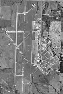 |
| USGS aerial photo, 22 Jan 1999 |
| IATA: PNX – ICAO: KGYI – FAA LID: GYI |
| Summary |
| Airport type |
Public |
| Owner |
Grayson County, Texas |
| Serves |
Sherman / Denison |
| Elevation AMSL |
749 ft / 228 m |
| Coordinates |
33°42′51″N 096°40′25″W / 33.71417°N 96.67361°W / 33.71417; -96.67361 |
| Runways |
| Direction |
Length |
Surface |
| ft |
m |
| 13/31 |
2,277 |
694 |
Asphalt |
| 17L/35R |
9,000 |
2,743 |
Asphalt/Concrete |
| Statistics (2007) |
| Aircraft operations |
53,300 |
| Based aircraft |
169 |
| Source: FAA and airport website |
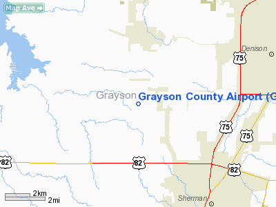
North Texas Regional Airport / Perrin Field (IATA: PNX, ICAO: KGYI, FAA LID: GYI) is a county-owned public use airport in Grayson County, Texas, United States. It is located between the cities of Sherman and Denison. Formerly known as Grayson County Airport, the airport was renamed in November 2007. It is used entirely for general aviation purposes. Several of the buildings are occupied by businesses, Grayson County government agencies, as well as Grayson County College.
Although most U.S. airports use the same three-letter location identifier for the FAA and IATA, this airport is assigned GYI by the FAA and PNX by the IATA (which assigned GYI to an airport in Gisenyi, Rwanda).
As a general aviation reliever airport, unconfirmed reports suggest that the airport might potentially (in the distant future) serve as a third airport for the Dallas/Fort Worth Metroplex to handle travelers from its growing northern suburbs. If this occurs, commercial traffic would be focused on regional jet airline operations. A planned extension of State Highway 289 would pass the airport on the west side. HistoryThe airport is located on the site of the former Perrin Air Force Base, which was built in 1941 and closed in 1971. Since the closure, a small group of local Sherman and Denison citizens have held the memory of Perrin together, hosting nine Perrin Field reunions since the early 1980s. The Perrin AFB Research Foundation was established in 1998. Today, in addition to serving as a general aviation airport, several businesses, as well as a juvenile detention center/boot-camp and adult probation center are built upon former barracks and nearby areas. There is a small museum dedicated to the former Perrin Air Force Base at the airport and Grayson County College uses several of the buildings for its course offerings. The college also operates the former base golf course.
After seeing the fighters take off from here, a young Chesley Sullenberger became interested in flying.
Facilities and aircraft
The airport covers an area of 1,410 acres (571 ha) at an elevation of 749 feet (228 m) above mean sea level. It has two runways: 17L/35R is 9,000 by 150 feet (2,743 x 46 m) with an asphalt/concrete surface; 13/31 is 2,277 by 60 feet (694 x 18 m) with an asphalt surface.
It originally had three runways, but one 8,000'(2,438m) runway is closed and is used solely as a taxiway. The airport has an operational Category I instrument landing system (ILS) to Runway 17L. The former USAF control tower resumed operations in mid-2008.
For the 12-month period ending April 30, 2007, the airport had 53,300 aircraft operations, an average of 146 per day: 98% general aviation, 2% military and <1% air taxi. At that time there were 169 aircraft based at this airport: 73% single-engine, 11% multi-engine, 11% jet, 4% helicopter and 1% ultralight.
The above content comes from Wikipedia and is published under free licenses – click here to read more.
Location & QuickFacts
| FAA Information Effective: | 2008-09-25 |
| Airport Identifier: | GYI |
| Airport Status: | Operational |
| Longitude/Latitude: | 096-40-25.2000W/33-42-50.8000N
-96.673667/33.714111 (Estimated) |
| Elevation: | 749 ft / 228.30 m (Surveyed) |
| Land: | 1200 acres |
| From nearest city: | 4 nautical miles W of Sherman/denison, TX |
| Location: | Grayson County, TX |
| Magnetic Variation: | 06E (1995) |
Owner & Manager
| Ownership: | Publicly owned |
| Owner: | Grayson County
GRAYSON COUNTY HAS TSFRD RSPBLTY FOR OPERG ARPT TO GRAYSON CTY ARPT BOARD. |
| Address: | County Courthouse
Sherman, TX 75090 |
| Phone number: | 903-813-4228 |
| Manager: | Mike Shahan
AIRPORT DIRECTOR. |
| Address: | 4700 Airport Dr
Denison, TX 75020 |
| Phone number: | 903-786-2904 |
Airport Operations and Facilities
| Airport Use: | Open to public |
| Wind indicator: | Yes |
| Segmented Circle: | Yes |
| Control Tower: | Yes |
| Lighting Schedule: | DUSK-DAWN
MIRL RY 17L/35R PRESET LOW INTST; TO INCR INTST & ACTVT MALSR RY 17L & MALS RY 35R - CTAF. |
| Beacon Color: | Clear-Green (lighted land airport) |
| Landing fee charge: | No |
| Sectional chart: | Dallas-ft Worth |
| Region: | ASW - Southwest |
| Traffic Pattern Alt: | 1000 ft |
| Boundary ARTCC: | ZFW - Fort Worth |
| Tie-in FSS: | FTW - Fort Worth |
| FSS on Airport: | No |
| FSS Phone: | 817-541-3474 |
| FSS Toll Free: | 1-800-WX-BRIEF |
| NOTAMs Facility: | GYI (NOTAM-d service avaliable) |
| Federal Agreements: | NGPY |
Airport Communications
| CTAF: | 120.575 |
| Unicom: | 122.700 |
Airport Services
| Fuel available: | 100LLA
FOR FUEL AFTER HRS CALL 903-786-6001. |
| Airframe Repair: | MAJOR |
| Power Plant Repair: | MAJOR |
| Bottled Oxygen: | HIGH |
Runway Information
Runway 13/31
| Dimension: | 2277 x 60 ft / 694.0 x 18.3 m |
| Surface: | ASPH, Good Condition |
| |
Runway 13 |
Runway 31 |
| Longitude: | 096-40-42.4906W | 096-40-26.2500W |
| Latitude: | 33-43-02.1454N | 33-42-44.1698N |
| Elevation: | 730.00 ft | 742.00 ft |
| Alignment: | 127 | 127 |
| Traffic Pattern: | Left | Left |
| Markings: | Basic, Good Condition | Basic, Good Condition |
|
Runway 17L/35R
| Dimension: | 9000 x 150 ft / 2743.2 x 45.7 m |
| Surface: | ASPH-CONC, Good Condition |
| Weight Limit: | Single wheel: 75000 lbs.
Dual wheel: 100000 lbs.
Dual tandem wheel: 160000 lbs. |
| Edge Lights: | Medium |
| |
Runway 17L |
Runway 35R |
| Longitude: | 096-40-21.2385W | 096-40-24.5508W |
| Latitude: | 33-43-34.7404N | 33-42-05.7497N |
| Elevation: | 741.00 ft | 749.00 ft |
| Alignment: | 127 | 2 |
| ILS Type: | ILS
| |
| Traffic Pattern: | Left | Left |
| Markings: | Precision instrument, Fair Condition | Precision instrument, Fair Condition |
| Crossing Height: | 39.00 ft | 41.00 ft |
| VASI: | 4-box on left side | 4-box on left side |
| Visual Glide Angle: | 2.50° | 2.50° |
| Approach lights: | MALSR | MALS |
|
Radio Navigation Aids
| ID |
Type |
Name |
Ch |
Freq |
Var |
Dist |
| DNI | NDB | Denison | | 341.00 | 06E | 6.6 nm |
| DUA | NDB | Durant | | 359.00 | 05E | 19.4 nm |
| HJM | NDB | Rayburn | | 415.00 | 06E | 25.6 nm |
| GLE | NDB | Gainesville | | 330.00 | 06E | 26.3 nm |
| AUV | NDB | Arbuckle | | 284.00 | 07E | 34.6 nm |
| MII | NDB | Caddo Mills | | 316.00 | 06E | 45.8 nm |
| MJF | TACAN | Arvilla | 033X | | 05E | 49.6 nm |
| URH | VOR/DME | Texoma | 090X | 114.30 | 05E | 19.7 nm |
| BYP | VORTAC | Bonham | 093X | 114.60 | 06E | 24.4 nm |
| ADM | VORTAC | Ardmore | 114X | 116.70 | 06E | 38.8 nm |
Remarks
- RY 17L/35R 5 FT HIGH DISTANCE-TO-GO MARKERS 150 FT ON EAST SIDE OF RY CNTRLN - UNLGTD.
Images and information placed above are from
http://www.airport-data.com/airport/GYI/
We thank them for the data!
| General Info
|
| Country |
United States
|
| State |
TEXAS
|
| FAA ID |
GYI
|
| Time |
UTC-6(-5DT)
|
| Latitude |
33.714111
33° 42' 50.80" N
|
| Longitude |
-96.673667
096° 40' 25.20" W
|
| Elevation |
749 feet
228 meters
|
| Magnetic Variation |
004° E (01/06)
|
| Beacon |
Yes
|
| Operating Agency |
U.S.CIVIL AIRPORT WHEREIN PERMIT COVERS USE BY TRANSIT MILITARY AIRCRAFT
|
| Near City |
Sherman Denison
|
| Operating Hours |
SEE REMARKS FOR OPERATING HOURS OR COMMUNICATIONS FOR POSSIBLE HOURS
|
| Daylight Saving Time |
Second Sunday in March at 0200 to first Sunday in November at 0200 local time (Exception Arizona and that portion of Indiana in the Eastern Time Zone)
|
We don't guarantee the information is fresh and accurate. The data may
be wrong or outdated.
For more up-to-date information please refer to other sources.
|
|


