 |
|
| Georgetown Municipal Airport |
| IATA: none – ICAO: KGTU – FAA LID: GTU |
| Summary |
| Airport type |
Public |
| Owner |
City of Georgetown |
| Serves |
Georgetown, Texas |
| Elevation AMSL |
790 ft / 241 m |
| Coordinates |
30°40′43.7124″N 097°40′45.7815″W / 30.678809°N 97.67938375°W / 30.678809; -97.67938375 |
| Runways |
| Direction |
Length |
Surface |
| ft |
m |
| 11/29 |
4,100 |
1,250 |
Asphalt |
| 18/36 |
5,000 |
1,524 |
Asphalt |
| Statistics (2008) |
| Aircraft operations |
127,700 |
| Based aircraft |
216 |
| Source: Federal Aviation Administration |
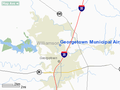
Georgetown Municipal Airport is a public use airport in Williamson County, Texas, United States. It is owned by the City of Georgetown and is located three nautical miles (5.56 km) north of the central business district. According to the FAA's National Plan of Integrated Airport Systems for 2007–2011, it is categorized as a reliever airport.
Although most U.S. airports use the same three-letter location identifier for the FAA and IATA, this airport is assigned GTU by the FAA but has no designation from the IATA.
Facilities and aircraft
Georgetown Municipal Airport covers an area of 640 acres (259 ha) at an elevation of 790 feet (241 m) above mean sea level. It has two asphalt runways designated 11/29, measuring 4,100 by 75 feet (1,250 x 23 m) and 18/36, measuring 5,000 by 100 feet (1,524 x 30 m).
For the 12-month period ending February 27, 2008, the airport had 127,700 aircraft operations, an average of 350 per day: 98% general aviation, 1% air taxi and 1% military. At that time there were 216 aircraft based at this airport: 84% single-engine, 12% multi-engine, 3% jet, 1% helicopters.
The above content comes from Wikipedia and is published under free licenses – click here to read more.
Location & QuickFacts
| FAA Information Effective: | 2008-09-25 |
| Airport Identifier: | GTU |
| Airport Status: | Operational |
| Longitude/Latitude: | 097-40-45.7815W/30-40-43.7124N
-97.679384/30.678809 (Estimated) |
| Elevation: | 790 ft / 240.79 m (Surveyed) |
| Land: | 640 acres |
| From nearest city: | 3 nautical miles N of Georgetown, TX |
| Location: | Williamson County, TX |
| Magnetic Variation: | 06E (2000) |
Owner & Manager
| Ownership: | Publicly owned |
| Owner: | City Of Georgetown |
| Address: | Po Box 409
Georgetown, TX 78627 |
| Phone number: | 512-930-3652 |
| Manager: | Travis Mclain |
| Address: | Po Box 409
Georgetown, TX 78627 |
| Phone number: | 512-930-3666
ALSO 512-863-0618. EMERGENCY 512-930-3510. |
Airport Operations and Facilities
| Airport Use: | Open to public |
| Wind indicator: | Yes |
| Segmented Circle: | Yes |
| Control Tower: | Yes |
| Lighting Schedule: | DUSK-DAWN
MIRL RY 18/36 PRESET LOW INTST; TO INCR INTST & ACTVT MIRL RY 11/29, REIL RY 18, & PAPI RYS 18 & 36 - CTAF. |
| Beacon Color: | Clear-Green (lighted land airport) |
| Landing fee charge: | No |
| Sectional chart: | San Antonio |
| Region: | ASW - Southwest |
| Boundary ARTCC: | ZHU - Houston |
| Tie-in FSS: | SJT - San Angelo |
| FSS on Airport: | No |
| FSS Toll Free: | 1-800-WX-BRIEF |
| NOTAMs Facility: | GTU (NOTAM-d service avaliable) |
| Federal Agreements: | NGY3 |
Airport Communications
| CTAF: | 120.225 |
| Unicom: | 123.000 |
Airport Services
| Fuel available: | 100LLA1+ |
| Airframe Repair: | MAJOR |
| Power Plant Repair: | MAJOR |
| Bottled Oxygen: | HIGH/LOW |
| Bulk Oxygen: | HIGH/LOW |
Runway Information
Runway 11/29
| Dimension: | 4100 x 75 ft / 1249.7 x 22.9 m |
| Surface: | ASPH, Good Condition |
| Weight Limit: | Single wheel: 12500 lbs. |
| Edge Lights: | Medium |
| |
Runway 11 |
Runway 29 |
| Longitude: | 097-41-10.2848W | 097-40-29.8643W |
| Latitude: | 30-40-52.9977N | 30-40-32.3665N |
| Elevation: | 790.00 ft | 759.00 ft |
| Alignment: | 121 | 127 |
| Traffic Pattern: | Left | Right |
| Markings: | Non-precision instrument, Good Condition | Non-precision instrument, Good Condition |
| Obstruction: | 26 ft tree, 530.0 ft from runway, 130 ft right of centerline, 12:1 slope to clear | 25 ft tree, 275.0 ft from runway, 140 ft left of centerline, 3:1 slope to clear
+10-30 FT BRUSH & TREES, 200 FT LEFT, 0-200 FT FROM THLD. |
|
Runway 18/36
| Dimension: | 5000 x 100 ft / 1524.0 x 30.5 m |
| Surface: | ASPH, Good Condition |
| Weight Limit: | Single wheel: 30000 lbs. |
| Edge Lights: | Medium |
| |
Runway 18 |
Runway 36 |
| Longitude: | 097-40-40.4849W | 097-40-44.0384W |
| Latitude: | 30-41-09.2501N | 30-40-19.8634N |
| Elevation: | 786.00 ft | 748.00 ft |
| Alignment: | 127 | 4 |
| Traffic Pattern: | Left | Right |
| Markings: | Non-precision instrument, Good Condition | Non-precision instrument, Good Condition |
| Crossing Height: | 35.00 ft | 35.00 ft |
| VASI: | 4-light PAPI on left side | 4-light PAPI on left side |
| Visual Glide Angle: | 3.00° | 3.00° |
| Runway End Identifier: | Yes | Yes |
| Obstruction: | 30 ft trees, 425.0 ft from runway, 280 ft right of centerline, 7:1 slope to clear | 35 ft trees, 320.0 ft from runway, 268 ft right of centerline, 3:1 slope to clear
3-8 FT BRUSH & TREES 150 FT LEFT, 50-200 FT FROM THLD. |
|
Radio Navigation Aids
| ID |
Type |
Name |
Ch |
Freq |
Var |
Dist |
| GUO | NDB | Georgetown | | 332.00 | 06E | 0.3 nm |
| IL | NDB | Iresh | | 278.00 | 07E | 20.8 nm |
| HLR | NDB | Hood | | 347.00 | 07E | 27.1 nm |
| BMQ | NDB | Burnet | | 341.00 | 07E | 29.0 nm |
| GR | NDB | Starn | | 323.00 | 07E | 31.1 nm |
| MFS | NDB | Horseshoe Bay Resort | | 403.00 | 07E | 36.3 nm |
| GYB | NDB | Lee County | | 385.00 | 07E | 47.5 nm |
| GRK | VOR/DME | Gray | 055X | 111.80 | 07E | 22.4 nm |
| TPL | VOR/DME | Temple | 041X | 110.40 | 09E | 34.5 nm |
| CWK | VORTAC | Centex | 075X | 112.80 | 06E | 19.6 nm |
| LZZ | VORTAC | Lampasas | 072X | 112.50 | 08E | 38.7 nm |
Remarks
- DEER ON & INVOF ARPT.
- MILITARY HELICOPTER OPNS PROHIBITED BTN 2100-0700.
- PORTIONS OF TWY E NOT VISIBLE FM TOWER.
- MIL FIELD PRIOR TO 1940.
Images and information placed above are from
http://www.airport-data.com/airport/GTU/
We thank them for the data!
| General Info
|
| Country |
United States
|
| State |
TEXAS
|
| FAA ID |
GTU
|
| Latitude |
30-40-43.712N
|
| Longitude |
097-40-45.782W
|
| Elevation |
790 feet
|
| Near City |
GEORGETOWN
|
We don't guarantee the information is fresh and accurate. The data may
be wrong or outdated.
For more up-to-date information please refer to other sources.
|
|


