|
|
| Garner Field |
 |
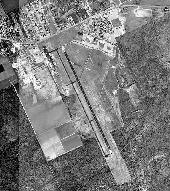
| 1995 USGS Photo |
| IATA: UVA – ICAO: KUVA – FAA LID: UVA |
| Summary |
| Airport type |
Public |
| Owner |
City of Uvalde |
| Serves |
Uvalde, Texas |
| Elevation AMSL |
942 ft / 287 m |
| Coordinates |
29°12′41″N 099°44′37″W / 29.21139°N 99.74361°W / 29.21139; -99.74361 |
| Runways |
| Direction |
Length |
Surface |
| ft |
m |
| 15/33 |
5,255 |
1,602 |
Asphalt |
| Statistics (2005) |
| Aircraft operations |
12,565 |
| Based aircraft |
48 |
| Source: Federal Aviation Administration |
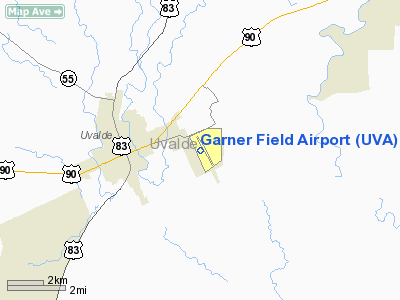
Garner Field (IATA: UVA, ICAO: KUVA, FAA LID: UVA) is a city-owned public-use airport located three nautical miles (6 km) east of the central business district of Uvalde, a city in Uvalde County, Texas, United States. The facility is named for John Nance Garner, 32nd Vice President of the United States. History
Opened in October 1941 with three 6'000 hard surfaced runways, (00/18; 04/27; 15/33). Began training United States Army Air Corps flying cadets under contract to Hangar Six Corp with 305th Fling Training Detachment (Contract Pilot School). Assigned to Gulf Coast Training Center (later Central Flying Training Command) as a primary (level 1) pilot training airfield. Hangar Six, Inc. conducted pilot training. Airfield had four local auxiliary airfields for emergency and overflow landings. Flying training was performed with Fairchild PT-19s as the primary trainer. Also had several PT-17 Stearmans and a few P-40 Warhawks assigned.
Inactivated on 30 June 1945 with the drawdown of AAFTC's pilot training program. Declared surplus and turned over to the Army Corps of Engineers on 30 September 1945. Eventually discharged to the War Assets Administration (WAA) and became a civil airport. Very little of the wartime airfield still exists, as most of the airfield has been rebuilt as Southwest Texas Junior College.
Facilities and aircraft
Garner Field covers an area of 356 acres (144 ha) at an elevation of 942 feet (287 m) above mean sea level. It has one runway designated 15/33 with a 5,255 by 100 ft (1,602 x 30 m) asphalt pavement. For the 12-month period ending April 7, 2005, the airport had 12,565 aircraft operations, an average of 34 per day: 96% general aviation, 2% air taxi and 2% military. At that time there were 48 aircraft based at this airport: 63% single-engine, 8% multi-engine, 13% jet, 8% helicopter and 8% glider.
The above content comes from Wikipedia and is published under free licenses – click here to read more.
Location & QuickFacts
| FAA Information Effective: | 2008-09-25 |
| Airport Identifier: | UVA |
| Airport Status: | Operational |
| Longitude/Latitude: | 099-44-36.9000W/29-12-40.8000N
-99.743583/29.211333 (Estimated) |
| Elevation: | 942 ft / 287.12 m (Surveyed) |
| Land: | 356 acres |
| From nearest city: | 3 nautical miles E of Uvalde, TX |
| Location: | Uvalde County, TX |
| Magnetic Variation: | 07E (2000) |
Owner & Manager
| Ownership: | Publicly owned |
| Owner: | City Of Uvalde |
| Address: | Po Box 799
Uvalde, TX 78801 |
| Phone number: | 830-278-3315 |
| Manager: | Mark Huffstutler |
| Address: | 122 Howard Langford Dr.
Uvalde, TX 78801 |
| Phone number: | 830-278-4481 |
Airport Operations and Facilities
| Airport Use: | Open to public |
| Wind indicator: | Yes |
| Segmented Circle: | Yes |
| Control Tower: | No |
| Lighting Schedule: | DUSK-DAWN
ACTVT MIRL RY 15/33 - CTAF. |
| Beacon Color: | Clear-Green (lighted land airport) |
| Landing fee charge: | No |
| Sectional chart: | San Antonio |
| Region: | ASW - Southwest |
| Boundary ARTCC: | ZHU - Houston |
| Tie-in FSS: | SJT - San Angelo |
| FSS on Airport: | No |
| FSS Toll Free: | 1-800-WX-BRIEF |
| NOTAMs Facility: | UVA (NOTAM-d service avaliable) |
| Federal Agreements: | NGY |
Airport Communications
| CTAF: | 122.800 |
| Unicom: | 122.800 |
Airport Services
| Fuel available: | 100LLA |
| Airframe Repair: | MAJOR |
| Power Plant Repair: | MAJOR |
| Bottled Oxygen: | HIGH/LOW |
| Bulk Oxygen: | HIGH/LOW |
Runway Information
Runway 15/33
| Dimension: | 5256 x 100 ft / 1602.0 x 30.5 m |
| Surface: | ASPH, Good Condition |
| Weight Limit: | Single wheel: 30000 lbs.
Dual wheel: 40000 lbs.
Dual tandem wheel: 40000 lbs. |
| Edge Lights: | Medium |
| |
Runway 15 |
Runway 33 |
| Longitude: | 099-44-49.4619W | 099-44-24.3631W |
| Latitude: | 29-13-04.3889N | 29-12-17.2429N |
| Elevation: | 942.00 ft | 925.00 ft |
| Alignment: | 127 | 127 |
| Traffic Pattern: | Left | Left |
| Markings: | Non-precision instrument, Good Condition | Non-precision instrument, Good Condition |
| Crossing Height: | 46.00 ft | 29.00 ft |
| VASI: | 2-box on left side | 2-box on left side |
| Visual Glide Angle: | 4.00° | 3.00° |
| Runway End Identifier: | Yes | Yes |
| Obstruction: | 45 ft trees, 700.0 ft from runway, 260 ft left of centerline, 11:1 slope to clear | , 50:1 slope to clear |
|
Radio Navigation Aids
| ID |
Type |
Name |
Ch |
Freq |
Var |
Dist |
| UVA | NDB | Uvalde | | 281.00 | 07E | 2.2 nm |
| LKX | NDB | La Pryor | | 223.00 | 09E | 17.9 nm |
| CPZ | NDB | Chaparrosa Ranch | | 385.00 | 10E | 22.8 nm |
| HMA | NDB | Hondo | | 329.00 | 08E | 31.5 nm |
| PFO | NDB | Spofford | | 356.00 | 08E | 36.1 nm |
| DMD | NDB | Dimmit County | | 343.00 | 07E | 41.6 nm |
| HHH | NDB | Devine | | 359.00 | 07E | 42.4 nm |
| BRX | NDB | La Fonda Ranch | | 269.00 | 09E | 46.2 nm |
| CVB | NDB | Castroville | | 338.00 | 08E | 47.6 nm |
| HDO | VOR/DME | Hondo | 31X | 109.40 | 08E | 30.8 nm |
Remarks
- TURF STRIP 3300' X 75' PARALLEL TO & EAST OF RWY 15/33 USED BY CROP DUSTERS ONLY.
Images and information placed above are from
http://www.airport-data.com/airport/UVA/
We thank them for the data!
| General Info
|
| Country |
United States
|
| State |
TEXAS
|
| FAA ID |
UVA
|
| Latitude |
29-12-40.861N
|
| Longitude |
099-44-36.899W
|
| Elevation |
941 feet
|
| Near City |
UVALDE
|
We don't guarantee the information is fresh and accurate. The data may
be wrong or outdated.
For more up-to-date information please refer to other sources.
|
|