 |
|
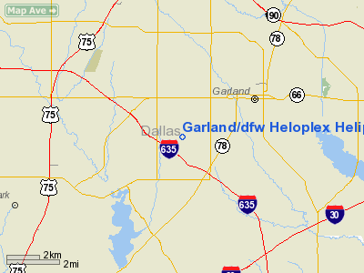
Garland/dfw Heloplex Heliport |
Location & QuickFacts
| FAA Information Effective: | 2008-09-25 |
| Airport Identifier: | T57 |
| Airport Status: | Operational |
| Longitude/Latitude: | 096-41-00.9870W/32-53-15.4500N
-96.683608/32.887625 (Estimated) |
| Elevation: | 601 ft / 183.18 m (Estimated) |
| Land: | 8 acres |
| From nearest city: | 2 nautical miles SW of Garland, TX |
| Location: | Dallas County, TX |
| Magnetic Variation: | 07E (1985) |
Owner & Manager
| Ownership: | Publicly owned |
| Owner: | City Of Garland |
| Address: | 205 N. 5th
Garland, TX 75040 |
| Phone number: | 214-349-7000 |
| Manager: | Connie Pyatt |
| Address: | 2559 S. Jupiter Rd.
Garland, TX 75041 |
| Phone number: | 214-349-7000 |
Airport Operations and Facilities
| Airport Use: | Open to public |
| Wind indicator: | Yes |
| Segmented Circle: | Yes |
| Control Tower: | No |
| Lighting Schedule: | DUSK-DAWN |
| Beacon Color: | Clear-Green-Yellow (heliport) |
| Sectional chart: | Dallas-ft Worth |
| Region: | ASW - Southwest |
| Boundary ARTCC: | ZFW - Fort Worth |
| Tie-in FSS: | FTW - Fort Worth |
| FSS on Airport: | No |
| FSS Phone: | 817-541-3474 |
| FSS Toll Free: | 1-800-WX-BRIEF |
| NOTAMs Facility: | FTW (NOTAM-d service avaliable) |
| Federal Agreements: | NGY |
Airport Communications
| CTAF: | 123.050 |
| Unicom: | 123.050 |
Airport Services
| Fuel available: | 100LLA |
| Airframe Repair: | MINOR |
| Power Plant Repair: | MINOR |
Runway Information
Helipad H1
| Dimension: | 105 x 105 ft / 32.0 x 32.0 m |
| Surface: | CONC, |
| |
Runway H1 |
Runway |
| Traffic Pattern: | Left | Left |
| Markings: | Basic, Good Condition | , |
|
Radio Navigation Aids
| ID |
Type |
Name |
Ch |
Freq |
Var |
Dist |
| PQF | NDB | Mesquite | | 248.00 | 06E | 9.1 nm |
| JUG | NDB | Jecca | | 388.00 | 06E | 15.3 nm |
| RBD | NDB | Redbird | | 287.00 | 06E | 15.8 nm |
| LNC | NDB | Lancaster | | 239.00 | 06E | 18.7 nm |
| XQH | NDB | Cedar Hill | | 353.00 | 08E | 23.2 nm |
| AVZ | NDB | Travis | | 260.00 | 06E | 23.2 nm |
| MII | NDB | Caddo Mills | | 316.00 | 06E | 23.8 nm |
| SYW | NDB | Cash | | 428.00 | 05E | 31.6 nm |
| MJF | TACAN | Arvilla | 033X | | 05E | 33.2 nm |
| NFW | TACAN | Nas Jrb Fort Worth | 024X | | 07E | 38.8 nm |
| CVE | VOR/DME | Cowboy | 109X | 116.20 | 06E | 11.1 nm |
| TTT | VOR/DME | Maverick | 078X | 113.10 | 06E | 18.1 nm |
| FUZ | VORTAC | Ranger | 104X | 115.70 | 06E | 25.0 nm |
| BYP | VORTAC | Bonham | 093X | 114.60 | 06E | 45.1 nm |
| CQY | VORTAC | Cedar Creek | 095X | 114.80 | 06E | 48.3 nm |
| DAL | VOT | Dallas Love Field | | 113.30 | | 8.8 nm |
| FTW | VOT | Fort Worth Meacham | | 108.20 | | 34.3 nm |
Images and information placed above are from
http://www.airport-data.com/airport/T57/
We thank them for the data!
| General Info
|
| Country |
United States
|
| State |
TEXAS
|
| FAA ID |
T57
|
| Latitude |
32-53-15.450N
|
| Longitude |
096-41-00.987W
|
| Elevation |
601 feet
|
| Near City |
GARLAND
|
We don't guarantee the information is fresh and accurate. The data may
be wrong or outdated.
For more up-to-date information please refer to other sources.
|
|


