 |
|
| Franklin County Airport |
| IATA: none – ICAO: none – FAA LID: F53 |
| Summary |
| Airport type |
Public |
| Owner |
Franklin County |
| Location |
Mount Vernon, Texas |
| Elevation AMSL |
411 ft / 125 m |
| Coordinates |
33°12′56″N 095°14′15″W / 33.21556°N 95.2375°W / 33.21556; -95.2375 |
| Runways |
| Direction |
Length |
Surface |
| ft |
m |
| 13/31 |
3,900 |
1,189 |
Asphalt |
| Statistics (2003) |
| Aircraft operations |
5,700 |
| Source: Federal Aviation Administration |
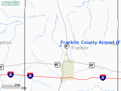
Franklin County Airport (FAA LID: F53) is a public airport located two miles (3 km) northwest of the central business district of Mount Vernon, a town in Franklin County, Texas, United States. It is owned by Franklin County.
Facilities and aircraft
Franklin County Airport covers an area of 159 acres (64 ha) which contains one asphalt paved runway, 13/31, measuring 3,900 x 60 ft (1,189 x 18 m). For the 12-month period ending December 17, 2003, the airport had 5,700 aircraft operations, 100% of which were general aviation.
The above content comes from Wikipedia and is published under free licenses – click here to read more.
Location & QuickFacts
| FAA Information Effective: | 2008-09-25 |
| Airport Identifier: | F53 |
| Airport Status: | Operational |
| Longitude/Latitude: | 095-14-14.0000W/33-12-55.2000N
-95.237222/33.215333 (Estimated) |
| Elevation: | 412 ft / 125.58 m (Surveyed) |
| Land: | 159 acres |
| From nearest city: | 2 nautical miles NW of Mount Vernon, TX |
| Location: | Franklin County, TX |
| Magnetic Variation: | 06E (1985) |
Owner & Manager
| Ownership: | Publicly owned |
| Owner: | Franklin County |
| Address: | Po Box 577
Mount Vernon, TX 75457 |
| Phone number: | 903-537-2342 |
| Manager: | Mark Mc Enturff
ARPT BOARD MEMBER/AIRPORT MANAGER. |
| Address: | 2138 Co Rd Nw 1030
Mount Vernon, TX 75457 |
| Phone number: | 903-537-4438 |
Airport Operations and Facilities
| Airport Use: | Open to public |
| Wind indicator: | Yes |
| Segmented Circle: | Yes |
| Control Tower: | No |
| Lighting Schedule: | DUSK-DAWN |
| Beacon Color: | Clear-Green (lighted land airport) |
| Sectional chart: | Dallas-ft Worth |
| Region: | ASW - Southwest |
| Boundary ARTCC: | ZFW - Fort Worth |
| Tie-in FSS: | FTW - Fort Worth |
| FSS Phone: | 817-541-3474 |
| FSS Toll Free: | 1-800-WX-BRIEF |
| NOTAMs Facility: | FTW (NOTAM-d service avaliable) |
| Federal Agreements: | NGY |
Airport Communications
| CTAF: | 123.000 |
| Unicom: | 123.000 |
Airport Services
| Fuel available: | 100LLA
SELF SERVICE FUEL BY CREDIT CARD ONLY. |
Runway Information
Runway 13/31
| Dimension: | 3900 x 60 ft / 1188.7 x 18.3 m |
| Surface: | ASPH, Good Condition |
| Weight Limit: | Single wheel: 12500 lbs. |
| Edge Lights: | Medium |
| |
Runway 13 |
Runway 31 |
| Longitude: | 095-14-29.8149W | 095-13-58.2001W |
| Latitude: | 33-13-09.1610N | 33-12-41.1851N |
| Elevation: | 396.00 ft | 412.00 ft |
| Alignment: | 127 | 127 |
| Traffic Pattern: | Left | Left |
| Markings: | Non-precision instrument, Good Condition | Non-precision instrument, Good Condition |
| Crossing Height: | 45.00 ft | 35.00 ft |
| VASI: | 2-light PAPI on left side
PAPI OTS INDEFLY. | 2-light PAPI on left side
PAPI OTS INDEFLY. |
| Visual Glide Angle: | 3.00° | 3.00° |
| Obstruction: | 25 ft trees, 430.0 ft from runway, 150 ft right of centerline, 9:1 slope to clear | 34 ft trees, 1570.0 ft from runway, 40:1 slope to clear |
|
Radio Navigation Aids
| ID |
Type |
Name |
Ch |
Freq |
Var |
Dist |
| LST | NDB | Lone Star | | 305.00 | 05E | 30.3 nm |
| ABG | NDB | Ambassador | | 404.00 | 07E | 38.4 nm |
| SYW | NDB | Cash | | 428.00 | 05E | 44.1 nm |
| IBO | NDB | Idabel | | 271.00 | 03E | 46.0 nm |
| TY | NDB | Tyler | | 320.00 | 06E | 49.5 nm |
| MJF | TACAN | Arvilla | 033X | | 05E | 42.4 nm |
| SLR | VOR/DME | Sulphur Springs | 027X | 109.00 | 08E | 15.4 nm |
| UIM | VOR/DME | Quitman | 087X | 114.00 | 08E | 21.2 nm |
| PRX | VOR/DME | Paris | 083X | 113.60 | 07E | 22.3 nm |
Remarks
- PRVDD A 90-DAY NOTICE IS FURNISHED FAA PRIOR TO ACTIVATION OF ARPT.
Images and information placed above are from
http://www.airport-data.com/airport/F53/
We thank them for the data!
| General Info
|
| Country |
United States
|
| State |
TEXAS
|
| FAA ID |
F53
|
| Latitude |
33-12-55.597N
|
| Longitude |
095-14-14.793W
|
| Elevation |
411 feet
|
| Near City |
MOUNT VERNON
|
We don't guarantee the information is fresh and accurate. The data may
be wrong or outdated.
For more up-to-date information please refer to other sources.
|
|


