 |
|
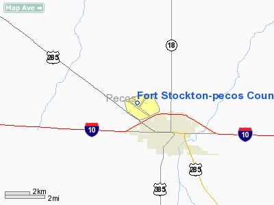
Fort Stockton-pecos County Airport |
| Fort Stockton-Pecos County Airport |
 |
| IATA: FST – ICAO: KFST |
| Summary |
| Airport type |
Public |
| Location |
Pecos County, near Fort Stockton, Texas |
| Elevation AMSL |
3,011 ft / 917.8 m |
| Coordinates |
30°54′54.90″N 102°54′46.0″W / 30.91525°N 102.91278°W / 30.91525; -102.91278Coordinates: 30°54′54.90″N 102°54′46.0″W / 30.91525°N 102.91278°W / 30.91525; -102.91278 |
| Runways |
| Direction |
Length |
Surface |
| ft |
m |
| 3/21 |
4,399 |
1,341 |
Asphalt |
| 7/25 |
4,961 |
1,512 |
Asphalt |
| 16/34 |
3,981 |
1,213 |
Asphalt |
| 11/29 |
3,348 |
1,020 |
Asphalt |
Fort Stockton-Pecos County Airport (IATA: FST, ICAO: KFST) is a general aviation airport located 2 miles NW of Fort Stockton, Texas.
It is owned and operated by Pecos County, Texas. History
The airport was opened as Gibbs Field , or Fort Stockton Field and was used by the United States Army Air Forces as a training base during World War II.
Opened on 1 June 1942 with two 2,500' turf runways. Began training United States Army Air Corps flying cadets under contract to Pacific Air School Ltd. Assigned to United States Army Air Forces Gulf Coast Training Center (later Central FLying Training Command) as a primary (level 1) pilot training airfield. had two local auxiliary airfields for emergency and overflow landings. Flying training was performed with Fairchild PT-19s as the primary trainer. Also had several PT-17 Stearmans and a few P-40 Warhawks assigned.
Inactivated on 12 March 1944 with the drawdown of AAFTC's pilot training program. Declared surplus and turned over to the Army Corps of Engineers on 30 September 1945. Eventually discharged to the War Assets Administration (WAA) and became a civil airport.
The above content comes from Wikipedia and is published under free licenses – click here to read more.
Location & QuickFacts
| FAA Information Effective: | 2008-09-25 |
| Airport Identifier: | FST |
| Airport Status: | Operational |
| Longitude/Latitude: | 102-54-46.0000W/30-54-54.9000N
-102.912778/30.915250 (Estimated) |
| Elevation: | 3011 ft / 917.75 m (Surveyed) |
| Land: | 1062 acres |
| From nearest city: | 2 nautical miles NW of Fort Stockton, TX |
| Location: | Pecos County, TX |
| Magnetic Variation: | 09E (1995) |
Owner & Manager
| Ownership: | Publicly owned |
| Owner: | Pecos County |
| Address: | Po Box 1624
Fort Stockton, TX 79735 |
| Phone number: | 432-336-6261
COUNTY COMMISSIONER GEORGE RIGGS, 432-336-6261. |
| Manager: | David Hardwick |
| Address: | Po Box 1109
Fort Stockton, TX 79735 |
| Phone number: | 432-336-9900
EVENING 432-336-6911. |
Airport Operations and Facilities
| Airport Use: | Open to public |
| Wind indicator: | Yes |
| Segmented Circle: | Yes |
| Control Tower: | No |
| Lighting Schedule: | DUSK-DAWN |
| Beacon Color: | Clear-Green (lighted land airport) |
| Landing fee charge: | No |
| Sectional chart: | San Antonio |
| Region: | ASW - Southwest |
| Boundary ARTCC: | ZAB - Albuquerque |
| Tie-in FSS: | SJT - San Angelo |
| FSS on Airport: | No |
| FSS Toll Free: | 1-800-WX-BRIEF |
| NOTAMs Facility: | FST (NOTAM-d service avaliable) |
| Federal Agreements: | NR1 |
Airport Communications
| CTAF: | 122.800 |
| Unicom: | 122.800 |
Airport Services
| Fuel available: | 100LLA
FOR FUEL & SVCS AFT HRS CALL 432-336-9900 OR UNICOM. 24 HR SELF SERVE AVBL WITH MAJOR CREDIT CARD. |
| Airframe Repair: | MINOR |
| Power Plant Repair: | MINOR |
| Bottled Oxygen: | NONE |
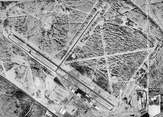
Runway Information
Runway 03/21
| Dimension: | 4399 x 60 ft / 1340.8 x 18.3 m |
| Surface: | ASPH, Good Condition |
| Edge Lights: | Medium |
| |
Runway 03 |
Runway 21 |
| Longitude: | 102-55-06.8320W | 102-54-36.7680W |
| Latitude: | 30-54-49.2310N | 30-55-24.2060N |
| Elevation: | 3007.00 ft | 2957.00 ft |
| Alignment: | 37 | 127 |
| Traffic Pattern: | Left | Left |
| Markings: | Basic, Good Condition | Basic, Good Condition |
| Obstruction: | 6 ft brush, 237.0 ft from runway, 30 ft right of centerline, 6:1 slope to clear | 7 ft tree, 350.0 ft from runway, 125 ft left of centerline, 21:1 slope to clear |
|
Runway 07/25
| Dimension: | 4961 x 150 ft / 1512.1 x 45.7 m |
| Surface: | TURF, Good Condition |
| |
Runway 07 |
Runway 25 |
| Longitude: | 102-54-58.4987W | 102-54-02.1492W |
| Latitude: | 30-54-55.0050N | 30-55-02.0693N |
| Elevation: | 2994.00 ft | 2966.00 ft |
| Alignment: | 82 | 127 |
| Traffic Pattern: | Left | Left |
| Obstruction: | , 50:1 slope to clear | 8 ft brush, 0.0 ft from runway, 70 ft right of centerline |
|
Runway 11/29
| Dimension: | 3348 x 100 ft / 1020.5 x 30.5 m |
| Surface: | TURF, Good Condition |
| |
Runway 11 |
Runway 29 |
| Longitude: | 102-54-58.7757W | 102-54-27.7941W |
| Latitude: | 30-54-53.5057N | 30-54-33.9012N |
| Elevation: | 2996.00 ft | 3005.00 ft |
| Alignment: | 126 | 127 |
| Traffic Pattern: | Left | Left |
| Obstruction: | , 50:1 slope to clear | 10 ft road, 210.0 ft from runway, 21:1 slope to clear |
|
Runway 12/30
| Dimension: | 7507 x 100 ft / 2288.1 x 30.5 m |
| Surface: | ASPH, Good Condition |
| Weight Limit: | Single wheel: 24000 lbs. |
| Edge Lights: | Medium |
| |
Runway 12 |
Runway 30 |
| Longitude: | 102-55-36.3850W | 102-54-27.1470W |
| Latitude: | 30-55-12.4230N | 30-54-28.2110N |
| Elevation: | 2985.00 ft | 3010.00 ft |
| Alignment: | 127 | 127 |
| Traffic Pattern: | Left | Left |
| Markings: | Non-precision instrument, Good Condition | Non-precision instrument, Good Condition |
| Crossing Height: | 45.00 ft | 0.00 ft |
| VASI: | 2-box on right side | |
| Visual Glide Angle: | 3.00° | 0.00° |
| Obstruction: | 8 ft brush, 425.0 ft from runway, 210 ft left of centerline, 28:1 slope to clear | 38 ft tree, 900.0 ft from runway, 310 ft left of centerline, 18:1 slope to clear
GRAVEL ROAD AT 60-130 FT ACROSS APCH. |
|
Runway 16/34
| Dimension: | 3981 x 150 ft / 1213.4 x 45.7 m |
| Surface: | TURF, |
| |
Runway 16 |
Runway 34 |
| Longitude: | 102-54-35.4120W | 102-54-28.6105W |
| Latitude: | 30-55-14.8526N | 30-54-35.8931N |
| Elevation: | 2964.00 ft | 3004.00 ft |
| Alignment: | 127 | 127 |
| Traffic Pattern: | Left | Left |
|
Radio Navigation Aids
| ID |
Type |
Name |
Ch |
Freq |
Var |
Dist |
| OHE | NDB | Monahans | | 214.00 | 09E | 39.8 nm |
| IMP | NDB | Marathon | | 388.00 | 10E | 42.6 nm |
| BWR | NDB | Brewster County | | 412.00 | 09E | 46.8 nm |
| PEQ | VOR/DME | Pecos | 055X | 111.80 | 11E | 47.6 nm |
| FST | VORTAC | Fort Stockton | 116X | 116.90 | 11E | 3.9 nm |
Remarks
- 3210 FT TOWER 2 MILES NE.
Images and information placed above are from
http://www.airport-data.com/airport/FST/
We thank them for the data!
| General Info
|
| Country |
United States
|
| State |
TEXAS
|
| FAA ID |
FST
|
| Latitude |
30-54-56.400N
|
| Longitude |
102-54-58.100W
|
| Elevation |
3011 feet
|
| Near City |
FORT STOCKTON
|
We don't guarantee the information is fresh and accurate. The data may
be wrong or outdated.
For more up-to-date information please refer to other sources.
|
|


