 |
|
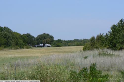 |
(Click on the photo to enlarge) |
Location & QuickFacts
| FAA Information Effective: | 2008-09-25 |
| Airport Identifier: | 2TE2 |
| Airport Status: | Operational |
| Longitude/Latitude: | 097-32-01.0810W/32-49-50.4590N
-97.533634/32.830683 (Estimated) |
| Elevation: | 720 ft / 219.46 m (Estimated) |
| Land: | 50 acres |
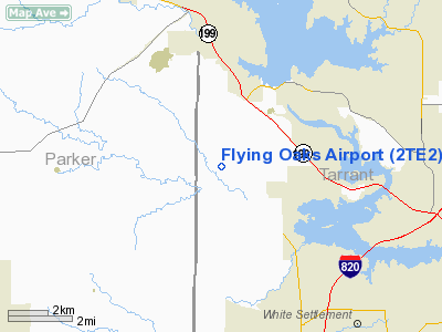
| From nearest city: | 10 nautical miles NW of Fort Worth, TX |
| Location: | Tarrant County, TX |
| Magnetic Variation: | 07E (1985) |
Owner & Manager
| Ownership: | Privately owned |
| Owner: | R. F. Pence |
| Address: | 7640 Confederate Park Road
Fort Worth, TX 76108 |
| Phone number: | 817-237-3486 |
| Manager: | R. F. Pence |
| Address: | 7640 Confederate Park Road
Fort Worth, TX 76108 |
| Phone number: | 817-237-9180 |
Airport Operations and Facilities
| Airport Use: | Private |
| Wind indicator: | Yes |
| Segmented Circle: | No |
| Control Tower: | No |
| Lighting Schedule: | PHONE REQ
FOR RED FLASHING LGT & RED OBSTRUCTION LGTS IN APCH RWY 33 - CALL 817-237-3486. |
| Landing fee charge: | No |
| Sectional chart: | Dallas-ft Worth |
| Region: | ASW - Southwest |
| Boundary ARTCC: | ZFW - Fort Worth |
| Tie-in FSS: | FTW - Fort Worth |
| FSS on Airport: | No |
| FSS Phone: | 817-541-3474 |
| FSS Toll Free: | 1-800-WX-BRIEF |
Airport Services
| Fuel available: | 100LL |
| Airframe Repair: | NONE |
| Power Plant Repair: | NONE |
| Bottled Oxygen: | NONE |
| Bulk Oxygen: | NONE |
Runway Information
Runway 15/33
| Dimension: | 2800 x 150 ft / 853.4 x 45.7 m |
| Surface: | TURF, Good Condition |
| |
Runway 15 |
Runway 33 |
| Traffic Pattern: | Left | Left |
| Markings: | None, | None, |
| Runway End Identifier: | No | No |
| Centerline Lights: | No | No |
| Touchdown Lights: | No | No |
| Obstruction: | 20 ft trees, 75 ft right of centerline | 15 ft tree, 0.0 ft from runway, 75 ft left of centerline |
|
Radio Navigation Aids
| ID |
Type |
Name |
Ch |
Freq |
Var |
Dist |
| MWL | NDB | Mineral Wells | | 266.00 | 06E | 26.6 nm |
| XQH | NDB | Cedar Hill | | 353.00 | 08E | 31.6 nm |
| RBD | NDB | Redbird | | 287.00 | 06E | 34.7 nm |
| LNC | NDB | Lancaster | | 239.00 | 06E | 43.8 nm |
| GZV | NDB | Brazos River | | 280.00 | 07E | 45.0 nm |
| GMZ | NDB | Grindstone Mountain | | 356.00 | 07E | 48.1 nm |
| NFW | TACAN | Nas Jrb Fort Worth | 024X | | 07E | 5.9 nm |
| TTT | VOR/DME | Maverick | 078X | 113.10 | 06E | 25.0 nm |
| CVE | VOR/DME | Cowboy | 109X | 116.20 | 06E | 32.0 nm |
| FUZ | VORTAC | Ranger | 104X | 115.70 | 06E | 18.2 nm |
| MQP | VORTAC | Millsap | 124X | 117.70 | 09E | 24.3 nm |
| JEN | VORTAC | Glen Rose | 097X | 115.00 | 06E | 43.9 nm |
| UKW | VORTAC | Bowie | 071X | 112.40 | 06E | 44.8 nm |
| FTW | VOT | Fort Worth Meacham | | 108.20 | | 8.9 nm |
| DAL | VOT | Dallas Love Field | | 113.30 | | 34.4 nm |
Images and information placed above are from
http://www.airport-data.com/airport/2TE2/
We thank them for the data!
| General Info
|
| Country |
United States
|
| State |
TEXAS
|
| FAA ID |
2TE2
|
| Latitude |
32-49-50.459N
|
| Longitude |
097-32-01.081W
|
| Elevation |
720 feet
|
| Near City |
FORT WORTH
|
We don't guarantee the information is fresh and accurate. The data may
be wrong or outdated.
For more up-to-date information please refer to other sources.
|
|


