 |
|
| Flying C Airport |
| IATA: none – ICAO: none – FAA LID: T87 |
| Summary |
| Airport type |
Public |
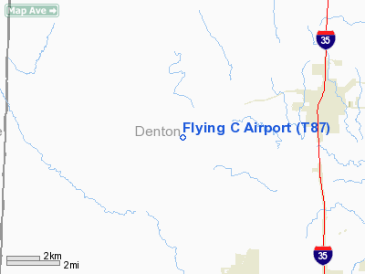
| Location |
Sanger, Texas |
| Elevation AMSL |
775 ft / 236 m |
| Coordinates |
33°20′32″N 097°16′12″W / 33.34222°N 97.27°W / 33.34222; -97.27Coordinates: 33°20′32″N 097°16′12″W / 33.34222°N 97.27°W / 33.34222; -97.27 |
| Runways |
| Direction |
Length |
Surface |
| ft |
m |
| 9/27 |
1,650 |
503 |
Turf |
| 17/35 |
1,400 |
427 |
Turf |
Flying C Airport (FAA LID: T87) is a public airport located five miles (8 km) southwest of the central business district (CBD) of Sanger, in Denton County, Texas, USA.
The airport is used solely for general aviation purposes.
Facilities
Flying C Airport has two runways:
- Runway 9/27: 1,650 x 90 ft. (503 x 27 m), Surface: Turf
- Runway 18/36: 1,400 x 140 ft. (427 x 43 m), Surface: Turf
The above content comes from Wikipedia and is published under free licenses – click here to read more.
Location & QuickFacts
| FAA Information Effective: | 2008-09-25 |
| Airport Identifier: | T87 |
| Airport Status: | Operational |
| Longitude/Latitude: | 097-16-12.0000W/33-20-32.0000N
-97.270000/33.342222 (Estimated) |
| Elevation: | 775 ft / 236.22 m (Estimated) |
| Land: | 88 acres |
| From nearest city: | 5 nautical miles SW of Sanger, TX |
| Location: | Denton County, TX |
| Magnetic Variation: | 06E (2000) |
Owner & Manager
| Ownership: | Privately owned |
| Owner: | Casey Carter |
| Address: | 8819 Bernard Road
Sanger, TX 76266 |
| Phone number: | 940-458-5628 |
| Manager: | Casey Carter |
| Address: | 8819 Bernard Road
Sanger, TX 76266 |
| Phone number: | 940-458-5628 |
Airport Operations and Facilities
| Airport Use: | Open to public |
| Wind indicator: | Yes |
| Segmented Circle: | No |
| Control Tower: | No |
| Sectional chart: | Dallas-ft Worth |
| Region: | ASW - Southwest |
| Boundary ARTCC: | ZFW - Fort Worth |
| Tie-in FSS: | FTW - Fort Worth |
| FSS Phone: | 817-541-3474 |
| FSS Toll Free: | 1-800-WX-BRIEF |
| NOTAMs Facility: | FTW (NOTAM-d service avaliable) |
Airport Communications
Runway Information
Runway 09/27
| Dimension: | 1650 x 90 ft / 502.9 x 27.4 m |
| Surface: | TURF, Fair Condition |
| |
Runway 09 |
Runway 27 |
| Traffic Pattern: | Left | Left |
| Obstruction: | 10 ft trees, 45 ft left of centerline | 25 ft tree, 0.0 ft from runway |
|
Runway 17/35
| Dimension: | 1400 x 140 ft / 426.7 x 42.7 m |
| Surface: | TURF, Fair Condition |
| |
Runway 17 |
Runway 35 |
| Traffic Pattern: | Left | Left |
| Obstruction: | 4 ft fence | 25 ft trees, 0.0 ft from runway |
|
Radio Navigation Aids
| ID |
Type |
Name |
Ch |
Freq |
Var |
Dist |
| GLE | NDB | Gainesville | | 330.00 | 06E | 22.9 nm |
| GMZ | NDB | Grindstone Mountain | | 356.00 | 07E | 29.8 nm |
| DNI | NDB | Denison | | 341.00 | 06E | 41.7 nm |
| RBD | NDB | Redbird | | 287.00 | 06E | 44.8 nm |
| XQH | NDB | Cedar Hill | | 353.00 | 08E | 47.5 nm |
| AUV | NDB | Arbuckle | | 284.00 | 07E | 49.1 nm |
| PQF | NDB | Mesquite | | 248.00 | 06E | 49.2 nm |
| NFW | TACAN | Nas Jrb Fort Worth | 024X | | 07E | 35.4 nm |
| TTT | VOR/DME | Maverick | 078X | 113.10 | 06E | 30.7 nm |
| CVE | VOR/DME | Cowboy | 109X | 116.20 | 06E | 32.8 nm |
| FUZ | VORTAC | Ranger | 104X | 115.70 | 06E | 27.6 nm |
| UKW | VORTAC | Bowie | 071X | 112.40 | 06E | 30.0 nm |
| FTW | VOT | Fort Worth Meacham | | 108.20 | | 31.8 nm |
| DAL | VOT | Dallas Love Field | | 113.30 | | 36.5 nm |
Remarks
- OCCASIONAL LIVESTOCK ON FIELD.
Images and information placed above are from
http://www.airport-data.com/airport/T87/
We thank them for the data!
|
|


