 |
|
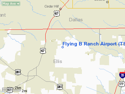
Location & QuickFacts
| FAA Information Effective: | 2008-09-25 |
| Airport Identifier: | TS71 |
| Airport Status: | Operational |
| Longitude/Latitude: | 096-56-38.0110W/32-31-40.4940N
-96.943892/32.527915 (Estimated) |
| Elevation: | 780 ft / 237.74 m (Estimated) |
| Land: | 0 acres |
| From nearest city: | 3 nautical miles SW of Ovilla, TX |
| Location: | Ellis County, TX |
| Magnetic Variation: | 06E (1984) |
Owner & Manager
| Ownership: | Privately owned |
| Owner: | Virginia L. Bean |
| Address: | 517 W Centerville Road
Garland, TX 75041-5445 |
| Phone number: | 214-775-3577 |
| Manager: | Virginia L. Bean |
| Address: | 517 W Centerville Road
Garland, TX 75041-5445 |
| Phone number: | 214-775-3577 |
Airport Operations and Facilities
| Airport Use: | Private |
| Segmented Circle: | No |
| Control Tower: | No |
| Sectional chart: | Dallas-ft Worth |
| Region: | ASW - Southwest |
| Boundary ARTCC: | ZFW - Fort Worth |
| Tie-in FSS: | FTW - Fort Worth |
| FSS Phone: | 817-541-3474 |
| FSS Toll Free: | 1-800-WX-BRIEF |
Runway Information
Runway 18/36
| Dimension: | 2400 x 70 ft / 731.5 x 21.3 m |
| Surface: | TURF, |
| |
Runway 18 |
Runway 36 |
| Traffic Pattern: | Left | Left |
| Obstruction: | 50 ft pline | 35 ft trees |
|
Radio Navigation Aids
| ID |
Type |
Name |
Ch |
Freq |
Var |
Dist |
| XQH | NDB | Cedar Hill | | 353.00 | 08E | 4.1 nm |
| RBD | NDB | Redbird | | 287.00 | 06E | 9.7 nm |
| LNC | NDB | Lancaster | | 239.00 | 06E | 11.6 nm |
| JUG | NDB | Jecca | | 388.00 | 06E | 22.5 nm |
| PQF | NDB | Mesquite | | 248.00 | 06E | 27.0 nm |
| AVZ | NDB | Travis | | 260.00 | 06E | 37.8 nm |
| CGQ | NDB | Powell | | 344.00 | 06E | 38.3 nm |
| CRS | NDB | Corsicana | | 396.00 | 06E | 41.0 nm |
| MII | NDB | Caddo Mills | | 316.00 | 06E | 46.7 nm |
| NFW | TACAN | Nas Jrb Fort Worth | 024X | | 07E | 29.0 nm |
| TTT | VOR/DME | Maverick | 078X | 113.10 | 06E | 21.1 nm |
| CVE | VOR/DME | Cowboy | 109X | 116.20 | 06E | 21.9 nm |
| FUZ | VORTAC | Ranger | 104X | 115.70 | 06E | 24.8 nm |
| CQY | VORTAC | Cedar Creek | 095X | 114.80 | 06E | 42.2 nm |
| DAL | VOT | Dallas Love Field | | 113.30 | | 19.7 nm |
| FTW | VOT | Fort Worth Meacham | | 108.20 | | 27.3 nm |
Remarks
- VFR USE ONLY; PTNS ARE ESTABLISHED TO AVOID TWRS NORTH OF ARPT.
Images and information placed above are from
http://www.airport-data.com/airport/TS71/
We thank them for the data!
| General Info
|
| Country |
United States
|
| State |
TEXAS
|
| FAA ID |
XS06
|
| Latitude |
32-17-54.524N
|
| Longitude |
097-08-58.029W
|
| Elevation |
665 feet
|
| Near City |
GRANDVIEW
|
We don't guarantee the information is fresh and accurate. The data may
be wrong or outdated.
For more up-to-date information please refer to other sources.
|
|


