 |
|
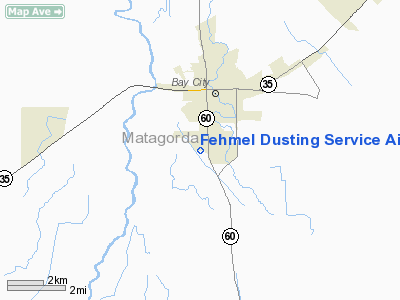
Fehmel Dusting Service Airport |
Location & QuickFacts
| FAA Information Effective: | 2008-09-25 |
| Airport Identifier: | T84 |
| Airport Status: | Operational |
| Longitude/Latitude: | 095-58-24.8490W/28-57-08.9270N
-95.973569/28.952480 (Estimated) |
| Elevation: | 50 ft / 15.24 m (Estimated) |
| Land: | 50 acres |
| From nearest city: | 2 nautical miles S of Bay City, TX |
| Location: | Matagorda County, TX |
| Magnetic Variation: | 06E (1985) |
Owner & Manager
| Ownership: | Privately owned |
| Owner: | Ronnie Fehmel |
| Address: | Po Box 1748
Bay City, TX 77404 |
| Phone number: | 979-245-3481 |
| Manager: | Ronnie Fehmel |
| Address: | Po Box 1748
Bay City, TX 77404 |
| Phone number: | 979-245-3481 |
Airport Operations and Facilities
| Airport Use: | Open to public |
| Wind indicator: | Yes |
| Segmented Circle: | No |
| Control Tower: | No |
| Landing fee charge: | No |
| Sectional chart: | Houston |
| Region: | ASW - Southwest |
| Boundary ARTCC: | ZHU - Houston |
| Tie-in FSS: | CXO - Montgomery County |
| FSS on Airport: | No |
| FSS Toll Free: | 1-800-WX-BRIEF
FOR FP FILING CALL CXO FSS 1-800-833-5602 |
| NOTAMs Facility: | CXO (NOTAM-d service avaliable) |
Airport Communications
Airport Services
Runway Information
Runway 14/32
| Dimension: | 2080 x 25 ft / 634.0 x 7.6 m |
| Surface: | ASPH, Fair Condition |
| Weight Limit: | Single wheel: 4000 lbs. |
| |
Runway 14 |
Runway 32 |
| Traffic Pattern: | Left | Left |
| Obstruction: | 25 ft trees, 205.0 ft from runway, 35 ft right of centerline
+5 FT PIPELINE MARKER POST 50 FT FM THLD 15 FT R; 35 FT TREE 75 FT R OF CNTRLN 120 FT FM THLD. | 40 ft trees, 200.0 ft from runway, 30 ft left of centerline
5 FT PIPELINE MARKER 40 FT FROM THLD 40 FT L OF CNTRLN; 50 FT TREE 90 FT R OF CNTRLN 105 FT FM THLD. |
|
Radio Navigation Aids
| ID |
Type |
Name |
Ch |
Freq |
Var |
Dist |
| BYY | NDB | Bay City | | 344.00 | 06E | 6.1 nm |
| ARM | NDB | Wharton | | 245.00 | 06E | 20.4 nm |
| PKV | NDB | Port Lavaca | | 515.00 | 05E | 41.5 nm |
| SYG | NDB | Sandy Point | | 402.00 | 05E | 42.4 nm |
| SGR | NDB | Hull | | 388.00 | 05E | 44.1 nm |
| ELA | VOR/DME | Eagle Lake | 111X | 116.40 | 08E | 46.3 nm |
| PSX | VORTAC | Palacios | 120X | 117.30 | 08E | 20.8 nm |
Remarks
- RWY 14/32 +30' TREES 40 WEST AND PARALLEL TO RWY CNTRLN ALONG ITS ENTIRE LENGTH.
Images and information placed above are from
http://www.airport-data.com/airport/T84/
We thank them for the data!
| General Info
|
| Country |
United States
|
| State |
TEXAS
|
| FAA ID |
T84
|
| Latitude |
28-57-08.927N
|
| Longitude |
095-58-24.849W
|
| Elevation |
50 feet
|
| Near City |
BAY CITY
|
We don't guarantee the information is fresh and accurate. The data may
be wrong or outdated.
For more up-to-date information please refer to other sources.
|
|


