|
 |
|
||||
|
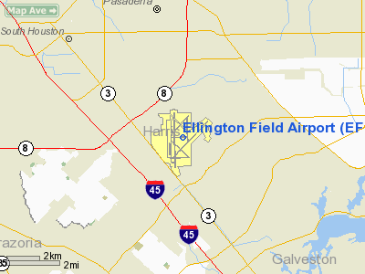
Ellington Airport (IATA: EFD, ICAO: KEFD, FAA LID: EFD) is a joint civil-military airport located in the U.S. state of Texas within the city of Houston—15 miles (24 km) southeast of Downtown. Established by the Army Air Service on 21 May 1917, Ellington Field was one of the initial World War I Army Air Service installations when aviation was in its infancy. Originally created as a training facility, Ellington Airport is currently used by military, commercial, NASA aircraft and general aviation sectors. Previously known as Ellington Field, the airport is a former air force base of the United States Air Force and is one of the few airfields built for World War I training purposes still in operation today. Overview
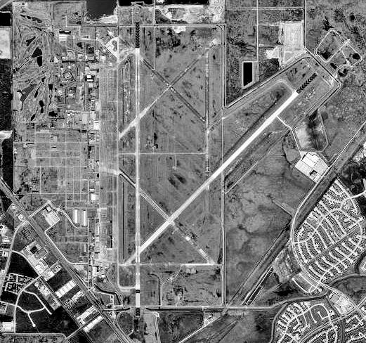
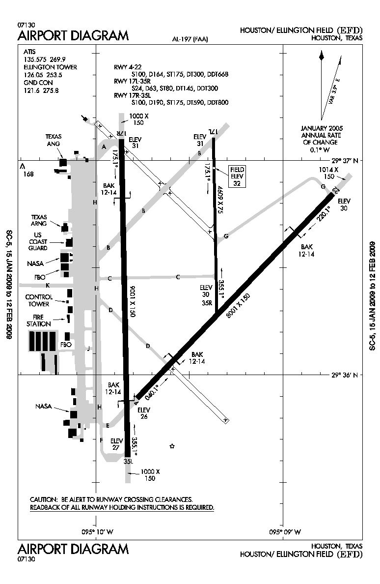
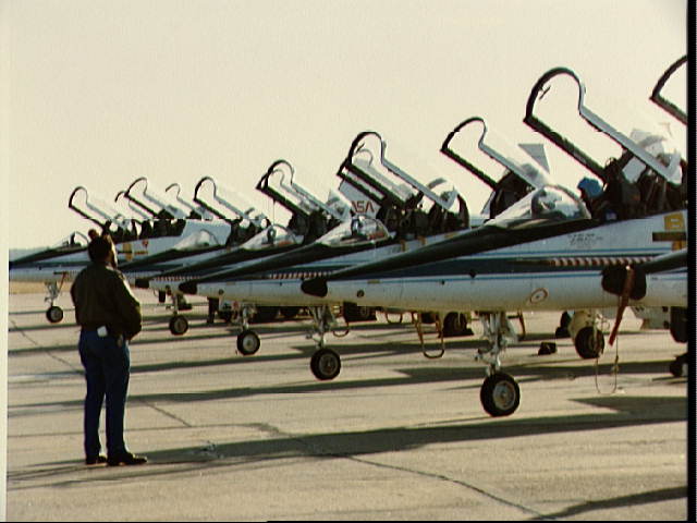
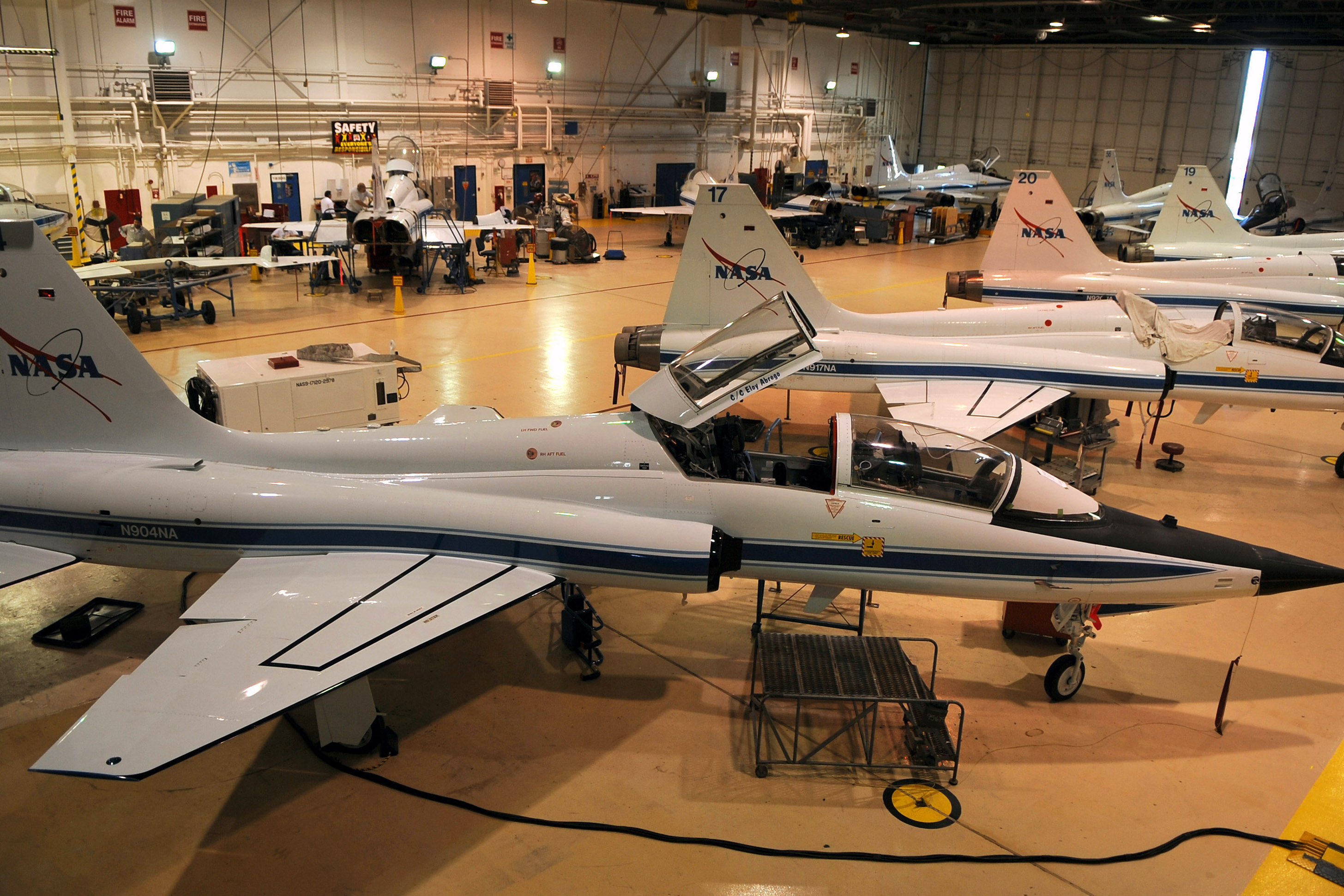
Ellington Airport consists of three active runways (a 9,001 - foot ILS CAT I runway, an 8,001-foot (2,439 m) runway, and a 4,609-foot (1,405 m) runway). The airport supports the operations of the United States military, NASA and a variety of general aviation tenants. The field is a base for NASA's administrative, cargo transport and high-altitude aircraft, which also includes NASA's fleet of T-38 Talon jets bailed to the agency from USAF, Gulfstream Shuttle Training Aircraft, and a former USN C-9 "Weightless Wonder VI" replaced the USAF NKC-135 aircraft known as the Vomit Comet, a zero-g trainer. The only two WB-57F aircraft used for atmospheric research and reconnaissance still flying in the world today are housed at Ellington. The Texas Air National Guard, Texas Army National Guard and the U.S. Coast Guard also maintain a presence at the base. The Coast Guard facility known as Coast Guard Air Station Houston operates 3 Eurocopter MH-56C "Dauphin" helicopters for search and rescue (SAR) and port security rolls. Ellington Field is also home to the largest flying club in Texas and the annual "Wings Over Houston" airshow. Ellington Field once had scheduled commercial air service: Continental Express flights between Ellington Airport and George Bush Intercontinental Airport in north Houston ended in 2004. Prior to the cessation of commercial air service, the route flown between Bush Intercontinental and Ellington Field was the shortest fixed-wing route flown in the United States at only 25 nautical miles. Flight times were as short as six minutes, depending on direction of departure. To this day, Ellington Field serves as a reliever airport for both Bush Intercontinental and the William P. Hobby Airport, and handles diverted aircraft from those two airports during bad weather events and peak traffic times. In 2005, the U.S. Department of Defense recommended retiring Ellington Field's 147th Fighter Wing F-16 Falcon fighter jets (a total of fifteen aircraft); this recommendation was approved by the Base Realignment and Closure committee. Some of the F-16s have been reassigned and the remainder mothballed at Davis Monthan AFB AMARG. 12 MQ-1 Predator Unmanned Aerial Vehicles (UAV) drones were assigned to the 147th, but do not base at KEFD. The unit has been redesignated as the 147th Reconnaissance Wing. The wing continues to be operationally gained by the Air Combat Command (ACC) and the wing's current combat support arm will remain intact, while the 272nd Engineering Installation Squadron, an Air National Guard unit currently located off-base, will relocate to Ellington Field. F-16 alert operations previously conducted by the 147th FW will be assumed by other Air National Guard fighter wings stationing rotational aircraft detachments at Ellington. HistoryPre–World War
In 1917, the U.S. government purchased 1,280 acres (5.2 km²) of land from Dr. R. W. Knox and the Wright Land Company to establish an airbase in Houston. The location, near Genoa Township in southeast Houston, was selected because the weather conditions were ideal for flight training. Soldiers from nearby Camp Logan briefly assisted with the construction of the airfield when civilian workers went on strike. Soon after construction began on the airfield, the base was named after Lt. Eric Lamar Ellington, an Army pilot killed four years earlier in a plane crash in San Diego, California. The base, which consisted of a few hangars and some wooden headquarters buildings, was completed in a matter of months. By the end of 1917, the field was ready to receive its first squadron — the 120th Aero Squadron, which was transferred from Kelly Field in San Antonio, Texas, along with its Curtiss JN4 Jenny biplanes, which were shipped in wooden crates via railroad. World War IDuring World War I, Ellington served as an advanced flight training base. As of 1918, Ellington had its own gunnery and bombing range on a small peninsula in the Gulf of Mexico near San Leon, Texas. Ellington became well-known in military circles, and had a series of "firsts", including the first camp newspaper, the first American aerial gunnery and bombing range, the first "canteen girls", and the first aerial ambulance in American military history. Before the end of the war, approximately 5,000 men and 250 aircraft were assigned to the base. Ellington was considered surplus to requirements after World War I and the base was deactivated as an active duty airfield in 1920. A small caretaker unit was kept at the airfield for administrative reasons, but generally, the only flight activity during this time was from Army pilots stationed at Kelly Field who flew down to practice landings on Ellington's runways. By 1923, Ellington had been ordered to be completely dismantled, but that plan was halted when the Texas National Guard established an aviation squadron at the field. Soon after, the 111th Observation Squadron (known colloquially as "Houston's Own" and later the 147th Fighter Wing) was born, also stationed at Ellington Field. The squadron, which flew Curtiss JN6Hs and De Havilland DH.4s, provided mapping, photography, and reconnaissance support for the 36th Infantry Division. Several years later in 1927, Ellington's status was again threatened as local city leaders began to discuss the construction of a municipal airport. That airport, the present day William P. Hobby Airport, confirmed the squadron's fears that Ellington's aging facilities were obsolete; as a result the Texas National Guard decided to move the 111th to new facilities at the municipal airport instead. The Texas National Guard and 36th Infantry Division bought most of the airfield's buildings, but the field remained unused; by 1928 Ellington was again overtaken by tall prairie grass. That same year, a fire engulfed what was left of the airfield, consuming its remaining structures, except for the concrete foundations and a metal water tower. For the next 12 years, the U.S. military leased the land to local ranchers for use as pasture. World War II
World War II, with its increasing need for trained pilots, helped to reestablish Ellington Field as an active facility. Rep. Albert Thomas, one of Houston's representatives in the United States House of Representatives, pushed for rebuilding Ellington as a pilot training center. Beyond the area's excellent weather for flying, Thomas argued that the Houston area's petroleum refineries, upon which the war effort depended, would need military protection in the region. In 1940, construction began on a much-expanded Ellington Field, which eventually included five control towers, two 46,000-square-foot (4,300 m) hangars, the most modern medical complex in south Texas and 74 barracks. Ellington became the home of the 69th, 70th, 71st, 72nd, 74th, 75th and 76th Fighter Squadrons. The base was one of the sites where bomber pilots received their advanced training and also housed the United States Army Air Corps' bombardier school, known as "the Bombardment Academy of the Air." In 1943, the bombardier school was replaced with a school for navigators. By the end of 1943, more than 65 women who served in the Women's Army Corps were also stationed at Ellington. The WACs worked in noncombat Army jobs in order to free men for combat duty. "By taking over an Army job behind the lines, she frees a fighting man to join his fellow soldiers on the road to Victory," stated WAC director Colonel Oveta Culp Hobby. Ellington served primarily as a reserve airbase from the end of the war in 1945 until 1948. Post war
In 1948, Ellington Airport was one of many airfields selected to be reactivated in an effort to maintain a large military force in the United States after World War II. The airfield was reopened for active duty and renamed Ellington Air Force Base. By 1949, the Air Force had rebuilt Ellington enough to open a USAF navigator school. Navigator cadets trained in TB-25 "Mitchell" and T-29 "Flying Classroom" aircraft. Navigation training was enhanced at Ellington when the Air Force installed a microwave navigation system. To help navigators learn celestial positioning, a Houston resident paid for the construction of a planetarium at Ellington. The planetarium, which stood 50 feet (15 m) high and was topped by an aluminum dome, could hold 40 students. The United States Navy opened a short-lived Naval Air Reserve Center at Ellington in 1957. Navy pilots and aircrews flew amphibious and land-based aircraft on antisubmarine and maritime patrol training missions over the Gulf of Mexico, but budget problems forced its closure just a year later. In 1959, Ellington was downgraded to a reserve Air Force Base, and has served the military in that capacity since; the Civil Air Patrol moved its headquarters from Bolling Air Force Base to Ellington the same year. In addition, Ellington also routinely hosted several college level Air Force Reserve Officer Training Corps summer courses/Field Training encampments, hosting officer candidates from 22 states. The Civil Air Patrol has since relocated their national headquarters to Maxwell AFB, Alabama, but a local CAP unit still remains at Ellington. The space age
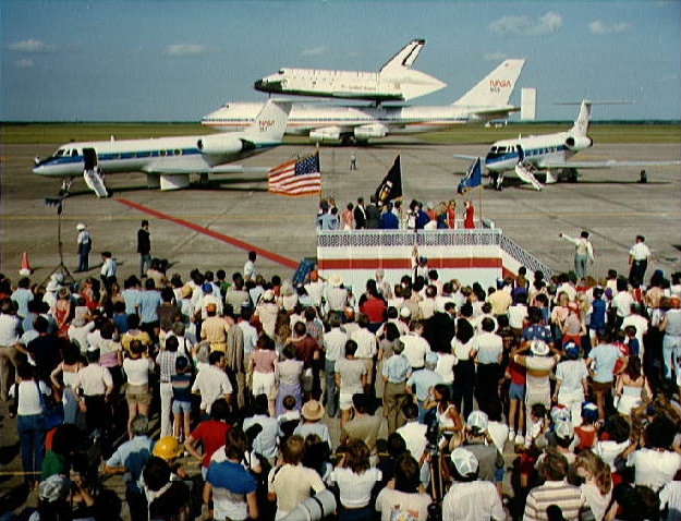
From the 1950s through the 1970s, Ellington Field was utilized for pilot and navigator training for active air force, air force reservists, air national guardsmen, and Navy, Marine, and foreign students. NASA established Ellington as its base for astronaut flight training in the early 1960s because of its proximity to the newly-constructed Lyndon B. Johnson Space Center. The T-38 Talon (T-38N) is the primary jet aircraft used for astronaut training at Ellington. The field was the site of the Apollo lunar landing training program. Most of NASA’s aircraft based at the Johnson Space Center are kept and maintained at the base. Ellington Field was officially deactivated by the Air Force in 1976 and all Air Force Reserve squadrons were transferred to other military facilities; however, the Texas Air National Guard, the Texas Army National Guard and the U.S. Coast Guard still maintain a military presence at the base. In 1984, the city of Houston purchased Ellington to use as a third civil airport, and it was renamed Ellington Airport on January 14, 2009. The above content comes from Wikipedia and is published under free licenses – click here to read more.
Location & QuickFacts
Owner & Manager
Airport Operations and Facilities
Airport Communications
Airport Services
Runway InformationRunway 04/22
Runway 17L/35R
Runway 17R/35L
Radio Navigation Aids
Remarks
Images and information placed above are from We thank them for the data!
We don't guarantee the information is fresh and accurate. The data may
be wrong or outdated.
|
||||||||||||||||||||||||||||||||||||||||||||||||||||||||||||||||||||||||||||||||||||||||||||||||||||||||||||||||||||||||||||||||||||||||||||||||||||||||||||||||||||||||||||||||||||||||||||||||||||||||||||||||||||||||||||||||||||||||||||||||||||||||||||||||||||||||||||||||||||||||||||||||||||||||||||||||||||||||||||||||||||||||||||||||||||||||||||||||||||||||||||||||||||||||||||||||||||||||||||||||||||||||||||||||||||||||||||||||||||||||||||||||||||||||||||||||||||||||||||||||||||||||

 |
|
Copyright 2004-2026 © by Airports-Worldwide.com, Vyshenskoho st. 36, Lviv 79010, Ukraine Legal Disclaimer |