|
|
| El Paso International Airport |
 |
 |
| IATA: ELP – ICAO: KELP
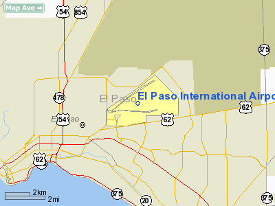
Location of the El Paso International Airport
|
| Summary |
| Airport type |
Public |
| Operator |
City of El Paso |
| Serves |
El Paso, Texas |
| Location |
El Paso, Texas |
| Elevation AMSL |
3,958 ft / 1,206 m |
| Coordinates |
31°48′26″N 106°22′39″W / 31.80722°N 106.3775°W / 31.80722; -106.3775 |
| Website |
http://www.elpasointernationalairport.com/ |
| Runways |
| Direction |
Length |
Surface |
| ft |
m |
| 4/22 |
12,020 |
3,664 |
Asphalt |
| 8R/26L |
9,025 |
2,751 |
Asphalt |
| 8L/26R |
5,493 |
1,674 |
Asphalt |
El Paso International Airport (IATA: ELP, ICAO: KELP, FAA LID: ELP) is a public airport located four miles (6 km) northeast of the central business district (CBD) of the City of El Paso, in El Paso County, Texas, USA.
Public transportation to and from the airport is provided by Sun Metro bus #33 and #57.
In 2009 there were 1,495,879 commercial passengers. HistoryThe city of El Paso had originally constructed the El Paso Municipal Airport at a location close to the East Side of the Franklin Mountains in 1928. The airport was abandoned by 1965, and in more recent times has been home to the Jobe Concrete Products "Planeport" cement factory.
The El Paso International Airport was originally constructed as Standard Airport, constructed by Standard Airlines in 1929 for transcontinental air mail service. Standard Airlines became a division of American Airlines in the 1930s. In 1936, American Airlines "swapped" airports with the city of El Paso, and the El Paso International Airport was born.
In 1934, Varney Speed Lines (now known as Continental Airlines) operated its service in and out of the old El Paso Municipal Airport (now closed). In 1937, the airline moved to Denver, Colorado when Robert Six took over the airline.
During World War II, the airport was used by the United States Army Air Forces as a training base. Units which trained at El Paso Army Airfield were:
- 385th Bombardment Group (Heavy) (B-17 Flying Fortress) December 21, 1942 – February 1, 1943
- Served with the 8th Air Force in England.
- 491st Bombardment Group (Heavy) (B-24 Liberator) November 11, 1943 – January 1, 1944
- Served with the 8th Air Force in England.
- 497th Bombardment Group (Very Heavy) (B-29 Superfortress) November 20 – December 1, 1943
- Served with the 20th Air Force at Saipan.
At the end of the war the airfield was determined to be excess by the military and returned to the local government for civil aviation use.
Historically, Continental Airlines had a significant presence at the airport. It provided "Golden Jet" service to such cities as Phoenix, Los Angeles, Las Vegas, Albuquerque, Midland-Odessa, Dallas Love Field, Austin, San Antonio and Houston. El Paso was the last stop of the first highjacking of a jetliner, a Boeing 707 owned by Continental Airlines. Before deregulation in the USA, El Paso was a focus city for Continental Airlines, however El Paso was soon demoted to a standard station in a hub-and-spoke system under Frank Lorenzo's leadership of the airline.
Facilities
El Paso International Airport covers 6,800 acres (2,752 ha) and has three runways:
- Runway 4/22: 12,020 x 150 ft (3,664 x 46 m), Surface: Asphalt
- Runway 8R/26L: 9,025 x 150 ft (2,751 x 46 m), Surface: Asphalt
- Runway 8L/26R: 5,493 x 75 ft (1,674 x 23 m), Surface: Asphalt
 | |
The Airport security concourse from airside. |
Airlines and destinations
El Paso International Airport has a total of 15 gates on 2 concourses: Concourse A consists of gates A1-A4, and Concourse B has gates B1-B11.
| Airlines |
Destinations |
Concourse |
| American Airlines |
Chicago-O’Hare [seasonal], Dallas/Fort Worth |
West |
| American Eagle |
Chicago-O'Hare |
West |
| Continental Airlines |
Houston-Intercontinental |
East |
| Continental Express operated by ExpressJet Airlines |
Houston-Intercontinental |
East |
| Delta Air Lines |
Atlanta |
East & West |
| Delta Connection operated by Atlantic Southeast Airlines |
Atlanta |
East |
| Southwest Airlines |
Albuquerque, Austin, Dallas-Love, Houston-Hobby, Las Vegas, Los Angeles, Phoenix, San Antonio, San Diego |
East |
| United Express operated by SkyWest Airlines |
Chicago-O’Hare, Denver, Los Angeles |
East |
| US Airways Express operated by Mesa Airlines |
Phoenix |
East |
Accidents and Incidents
- On 20 July 1982, Douglas C-47D N102BL of Pronto Aviation Services was damaged beyond repair in a crash landing near El Paso International Airport following an engine failure shortly after take-off. The aircraft was on a domestic non-scheduled passenger flight to Tucson International Airport, Arizona when the engine failed and the decision was made to return to El Paso. A single engine go-around was attempted following an unsafe landing gear warning.
- On February 19, 1988, Don McCoy, a private pilot, the owner of El Paso Sand and Gravel, took off in a newly acquired Rockwell Aero Commander 680 in a snowstorm (an aircraft he was not properly rated to fly), and attempted to land again after encountering mechanical trouble in instrument meteorological conditions (IMC). The aircraft crashed, killing the owner and two acquaintances. Some attempted to attribute the accident to US Senator Phil Gramm, as Mr. McCoy was due to testify against Senator Gramm's shakedown of campaign contributions made by the El Paso Small Business Administration office.
- On January 16, 2006 a mechanic employed by a contractor of Continental Airlines was killed when he was sucked into the right engine of a Boeing 737-500 preparing to take off as Continental Airlines Flight 1515 to George Bush Intercontinental Airport in Houston.
The above content comes from Wikipedia and is published under free licenses – click here to read more.
Location & QuickFacts
| FAA Information Effective: | 2008-09-25 |
| Airport Identifier: | ELP |
| Airport Status: | Operational |
| Longitude/Latitude: | 106-22-39.2000W/31-48-26.1000N
-106.377556/31.807250 (Estimated) |
| Elevation: | 3959 ft / 1206.70 m (Surveyed) |
| Land: | 6670 acres |
| From nearest city: | 4 nautical miles NE of El Paso, TX |
| Location: | El Paso County, TX |
| Magnetic Variation: | 11E (1985) |
Owner & Manager
| Ownership: | Publicly owned |
| Owner: | City Of El Paso |
| Address: | 2 Civic Center Plaza
El Paso, TX 79901 |
| Phone number: | 915-541-4000 |
| Manager: | Patrick Abeln |
| Address: | 6701 Convair Rd
El Paso, TX 79925 |
| Phone number: | 915-780-4749 |
Airport Operations and Facilities
| Airport Use: | Open to public |
| Wind indicator: | Yes |
| Segmented Circle: | No |
| Control Tower: | Yes |
| Lighting Schedule: | DUSK-DAWN |
| Beacon Color: | Clear-Green (lighted land airport) |
| Landing fee charge: | No |
| Sectional chart: | El Paso |
| Region: | ASW - Southwest |
| Boundary ARTCC: | ZAB - Albuquerque |
| Tie-in FSS: | ABQ - Albuquerque |
| FSS on Airport: | No |
| FSS Toll Free: | 1-800-WX-BRIEF |
| NOTAMs Facility: | ELP (NOTAM-d service avaliable) |
| Certification type/date: | I C S 05/1973 |
| Federal Agreements: | NGPRY3 |
Airport Communications
Airport Services
| Fuel available: | 100LLA1+ B+
FOR FUEL AT MIL RAMP CTC ATLANTIC AVIATION 122.95 OR 915-779-2831. |
| Airframe Repair: | MAJOR |
| Power Plant Repair: | MAJOR |
| Bottled Oxygen: | LOW |
| Bulk Oxygen: | LOW |
Runway Information
Runway 04/22
| Dimension: | 12020 x 150 ft / 3663.7 x 45.7 m |
| Surface: | ASPH, Good Condition |
| Surface Treatment: | Saw-cut or plastic Grooved |
| Weight Limit: | Single wheel: 100000 lbs.
Dual wheel: 180000 lbs.
Dual tandem wheel: 350000 lbs. |
| Edge Lights: | High |
| |
Runway 04 |
Runway 22 |
| Longitude: | 106-23-59.4637W | 106-22-12.7819W |
| Latitude: | 31-48-05.5576N | 31-49-22.0116N |
| Elevation: | 3917.00 ft | 3949.00 ft |
| Alignment: | 50 | 127 |
| ILS Type: | LOC/DME
| ILS/DME
|
| Traffic Pattern: | Left | Right |
| Markings: | Precision instrument, Good Condition | Precision instrument, Good Condition |
| Crossing Height: | 55.00 ft | 0.00 ft |
| VASI: | 4-light PAPI on left side | |
| Visual Glide Angle: | 3.00° | 0.00° |
| RVR Equipment: | touchdown, rollout | touchdown, rollout |
| Approach lights: | | MALSR |
| Runway End Identifier: | Yes | |
| Decleard distances: | Take off run available 12020.00 ft
Take off distance available 12020.00 ft
Actual stop distance available 12020.00 ft
Landing distance available 12020.00 ft
| Take off run available 12020.00 ft
Take off distance available 12020.00 ft
Actual stop distance available 12449.00 ft
Landing distance available 12020.00 ft
|
|
Runway 08L/26R
| Dimension: | 5499 x 75 ft / 1676.1 x 22.9 m |
| Surface: | ASPH, Fair Condition |
| Weight Limit: | Single wheel: 60000 lbs.
Dual wheel: 180000 lbs. |
| Edge Lights: | Medium |
| |
Runway 08L |
Runway 26R |
| Longitude: | 106-22-11.4555W | 106-21-07.7739W |
| Latitude: | 31-48-20.5810N | 31-48-22.1737N |
| Elevation: | 3952.00 ft | 3949.00 ft |
| Alignment: | 88 | 127 |
| Traffic Pattern: | Left | Right |
| Markings: | Basic, Good Condition | Basic, Good Condition |
| Decleard distances: | Take off run available 5493.00 ft
Take off distance available 5493.00 ft
Actual stop distance available 5493.00 ft
Landing distance available 5493.00 ft
| Take off run available 5493.00 ft
Take off distance available 5493.00 ft
Actual stop distance available 5493.00 ft
Landing distance available 5493.00 ft
|
|
Runway 08R/26L
| Dimension: | 9025 x 150 ft / 2750.8 x 45.7 m |
| Surface: | ASPH, |
| Surface Treatment: | Saw-cut or plastic Grooved |
| Weight Limit: | Single wheel: 100000 lbs.
Dual wheel: 180000 lbs.
Dual tandem wheel: 350000 lbs. |
| Edge Lights: | High |
| |
Runway 08R |
Runway 26L |
| Longitude: | 106-23-31.8539W | 106-21-47.4722W |
| Latitude: | 31-48-07.9768N | 31-48-02.8246N |
| Elevation: | 3925.00 ft | 3958.00 ft |
| Alignment: | 93 | 127 |
| Traffic Pattern: | Right | Left |
| Markings: | Non-precision instrument, Good Condition | Non-precision instrument, Good Condition |
| Crossing Height: | 68.00 ft | 75.00 ft |
| VASI: | 4-light PAPI on left side | 4-light PAPI on left side |
| Visual Glide Angle: | 3.00° | 3.00° |
| Approach lights: | | ODALS |
| Runway End Identifier: | Yes | |
| Decleard distances: | Take off run available 9025.00 ft
Take off distance available 9025.00 ft
Actual stop distance available 9025.00 ft
Landing distance available 9025.00 ft
| Take off run available 9025.00 ft
Take off distance available 9025.00 ft
Actual stop distance available 9025.00 ft
Landing distance available 9025.00 ft
|
|
Radio Navigation Aids
| ID |
Type |
Name |
Ch |
Freq |
Var |
Dist |
| EL | NDB | Valtr | | 242.00 | 11E | 4.4 nm |
| CJS | VOR/DME | Ciudad Juarez | 114X | 116.70 | 11E | 10.6 nm |
| ELP | VORTAC | El Paso | 099X | 115.20 | 12E | 4.9 nm |
| EWM | VORTAC | Newman | 071X | 112.40 | 12E | 10.2 nm |
| ELP | VOT | El Paso Intl | | 111.00 | | 0.5 nm |
Remarks
- 24 HR PPR CLASS A EXPLOSIVES CTC 915-780-4749.
- HOLDING POSITION MARKINGS FOR RUNWAY 8R APPROACH AND RUNWAY 4/22 ARE IN CLOSE PROXIMITY TO THE TERMINAL APRON; REVIEW AIRPORT DIAGRAM PRIOR TO PUSHBACK FROM THE GATE.
- MILITARY USERS SHOULD REVIEW NOISE ABATEMENT PROCEDURES LISTED FOR BIGGS AAF.
- NOISE ABATEMENT PROCEDURES IN EFFECT, CTC ATCT FOR DETAILS.
- ENGINE POWER IS RSTRD TO IDLE POWER ON ONE ENGINE AT A TIME FOR MAX 5 MIN ON ANY TERMINAL OR PARKING APRONS, CROSS-BLEED STARTS OR OTHER PRE DEP ACTIVITY ON MOVEMENT AREAS ONLY, MAINT OR OTR RQRMT NEEDING LONGER OR HIGHER POWER CTC TWR FOR DIRECTIONS TO DESIGNATED RUNUP AREAS.
- 611 FT AGL UNLGTD SMOKESTACK 8 MILES WSW OF ARPT.
- TWY M CLSD BTN RY 04/22 AND TWY K INDEFLY.
- TWY J CLSD BTN TWY N & AER 08R INDEFLY.
- CTN: BIGGS AAF 2NM NW RWY 21 CAN BE MISTAKEN FOR ELP RWY 22.
- TWY J CLSD BTN RY 08R & TWY P INDEFLY.
- SAILPLANE & ULTRALIGHT OPNS INVOF HORIZON ARPT 8 NM ESE.
- NORTH BOUND TFC PROHIBITED ON TWY F SOUTH OF TWY E.
- TWY A SOUTH OF TWY E; TWYS B & C; TWY J NE OF TWY K1; TWY K NE OF TWY K1 BTN TWY J & NORTH CARGO RAMP; TWYS U & V SOUTH OF TWY L; & TWY K2 NOT VISIBLE FM ATCT.
Images and information placed above are from
http://www.airport-data.com/airport/ELP/
We thank them for the data!
| General Info
|
| Country |
United States
|
| State |
TEXAS
|
| FAA ID |
ELP
|
| Latitude |
31-48-24.000N
|
| Longitude |
106-22-40.100W
|
| Elevation |
3958 feet
|
| Near City |
EL PASO
|
We don't guarantee the information is fresh and accurate. The data may
be wrong or outdated.
For more up-to-date information please refer to other sources.
|
|