 |
|
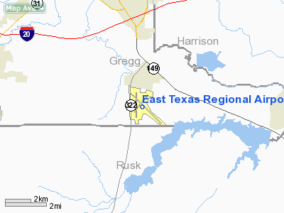
| East Texas Regional Airport |
| IATA: GGG – ICAO: KGGG |
| Summary |
| Airport type |
Public |
| Operator |
Gregg County, Texas |
| Location |
Longview, Texas |
| Elevation AMSL |
365 ft / 111 m |
| Coordinates |
32°23′02.452″N 94°42′41.352″W / 32.38401444°N 94.71148667°W / 32.38401444; -94.71148667Coordinates: 32°23′02.452″N 94°42′41.352″W / 32.38401444°N 94.71148667°W / 32.38401444; -94.71148667 |
| Runways |
| Direction |
Length |
Surface |
| ft |
m |
| 18/36 |
6,109 |
1,862 |
Asphalt |
| 13/31 |
10,000 |
3,048 |
Asphalt |
East Texas Regional Airport (IATA: GGG, ICAO: KGGG) is a public airport located eight miles south of Longview, Texas. The airport has 2 runways.
GGG is mostly used for general aviation but is also served by American Airlines/American Eagle.
GGG has two FBOs, Stebbins Aviation and KRS Aviation.
It is also the home Airport of LeTourneau University Flight Training Department. LeTourneau constitutes a very large portion of the airport traffic and has a multitude of airplanes from Cessna 172s to Beechcraft Duchesses, Citabrias and Diamond DA-42 Twinstars. All LeTourneau Cessna 172s have tail numbers ending in "LU".LETU Aero-Science picture
The GGG symbol comes from its prior name, Gregg County Airport, as it is located in Gregg County, Texas.
Airlines and destinations
| Airlines |
Destinations |
| American Eagle |
Dallas/Ft. Worth |
The above content comes from Wikipedia and is published under free licenses – click here to read more.
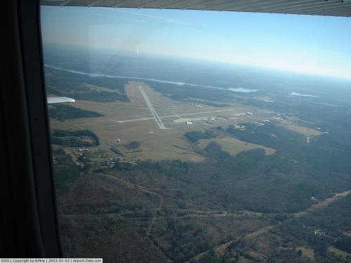 |
(Click on the photo to enlarge) |
Location & QuickFacts
| FAA Information Effective: | 2008-09-25 |
| Airport Identifier: | GGG |
| Airport Status: | Operational |
| Longitude/Latitude: | 094-42-41.3520W/32-23-02.4520N
-94.711487/32.384014 (Estimated) |
| Elevation: | 365 ft / 111.25 m (Surveyed) |
| Land: | 1300 acres |
| From nearest city: | 8 nautical miles S of Longview, TX |
| Location: | Gregg County, TX |
| Magnetic Variation: | 06E (1980) |
Owner & Manager
| Ownership: | Publicly owned |
| Owner: | Gregg County |
| Address: | Gregg County Courthouse
Longview, TX 75601 |
| Phone number: | 903-758-6181 |
| Manager: | Virginia Hall |
| Address: | 269 Terminal Circle
Longview, TX 75603 |
| Phone number: | 903-643-3031 |
Airport Operations and Facilities
| Airport Use: | Open to public |
| Wind indicator: | Yes |
| Segmented Circle: | Yes |
| Control Tower: | Yes |
| Lighting Schedule: | DUSK-DAWN
WHEN ATCT CLSD ACTVT MALSR RY 13 & VASI RYS 17; 35 & 31 - CTAF. MIRL RY 17/35 NOT AVBL WHEN ATCT CLSD. |
| Beacon Color: | Clear-Green (lighted land airport) |
| Landing fee charge: | No |
| Sectional chart: | Memphis |
| Region: | ASW - Southwest |
| Boundary ARTCC: | ZFW - Fort Worth |
| Tie-in FSS: | FTW - Fort Worth |
| FSS on Airport: | No |
| FSS Phone: | 817-541-3474 |
| FSS Toll Free: | 1-800-WX-BRIEF |
| NOTAMs Facility: | DAL (NOTAM-d service avaliable) |
| Certification type/date: | I A S 05/1973
PPR FOR UNSCHEDULED ACR OPNS WITH OVER 30 PSGR SEATS. ARFF NOT AVBL 2200-0600. |
| Federal Agreements: | NGY3 |
Airport Communications
| CTAF: | 119.200 |
| Unicom: | 122.950 |
Airport Services
| Fuel available: | 100LLA
FOR FUEL AFT HRS CALL 903-643-8748. |
| Airframe Repair: | MAJOR |
| Power Plant Repair: | MAJOR |
| Bottled Oxygen: | HIGH/LOW |
| Bulk Oxygen: | NONE |
Runway Information
Runway 13/31
| Dimension: | 10000 x 150 ft / 3048.0 x 45.7 m |
| Surface: | ASPH, Good Condition |
| Surface Treatment: | Saw-cut or plastic Grooved |
| Weight Limit: | Single wheel: 95000 lbs.
Dual wheel: 155000 lbs.
Dual tandem wheel: 288000 lbs. |
| Edge Lights: | High |
| |
Runway 13 |
Runway 31 |
| Longitude: | 094-43-12.4434W | 094-41-48.2576W |
| Latitude: | 32-23-33.1597N | 32-22-24.6970N |
| Elevation: | 357.00 ft | 354.00 ft |
| Alignment: | 127 | 127 |
| ILS Type: | ILS
| |
| Traffic Pattern: | Left | Left |
| Markings: | Precision instrument, Fair Condition | Precision instrument, Fair Condition |
| Crossing Height: | 0.00 ft | 52.00 ft |
| VASI: | | 4-box on left side |
| Visual Glide Angle: | 0.00° | 3.00° |
| RVR Equipment: | touchdown | |
| Approach lights: | MALSR | |
| Decleard distances: | Take off run available 10000.00 ft
Take off distance available 10000.00 ft
Actual stop distance available 10000.00 ft
Landing distance available 10000.00 ft
| Take off run available 10000.00 ft
Take off distance available 10000.00 ft
Actual stop distance available 10000.00 ft
Landing distance available 10000.00 ft
|
|
Runway 17/35
| Dimension: | 6109 x 150 ft / 1862.0 x 45.7 m |
| Surface: | ASPH, Good Condition |
| Surface Treatment: | Saw-cut or plastic Grooved |
| Weight Limit: | Single wheel: 95000 lbs.
Dual wheel: 155000 lbs.
Dual tandem wheel: 280000 lbs. |
| Edge Lights: | Medium |
| |
Runway 17 |
Runway 35 |
| Longitude: | 094-43-00.1138W | 094-42-58.6090W |
| Latitude: | 32-23-38.4331N | 32-22-38.0045N |
| Elevation: | 354.00 ft | 365.00 ft |
| Alignment: | 127 | 127 |
| Traffic Pattern: | Left | Left |
| Markings: | Non-precision instrument, Good Condition | Non-precision instrument, Good Condition |
| Crossing Height: | 53.00 ft | 51.00 ft |
| VASI: | 4-box on left side | 4-box on left side |
| Visual Glide Angle: | 3.00° | 3.00° |
| Obstruction: | 46 ft tree, 1584.0 ft from runway, 465 ft right of centerline, 30:1 slope to clear | 52 ft tree, 1813.0 ft from runway, 446 ft right of centerline, 31:1 slope to clear |
| Decleard distances: | Take off run available 6109.00 ft
Take off distance available 6109.00 ft
Actual stop distance available 6109.00 ft
Landing distance available 6109.00 ft
| Take off run available 6109.00 ft
Take off distance available 6109.00 ft
Actual stop distance available 6109.00 ft
Landing distance available 6109.00 ft
|
|
Radio Navigation Aids
| ID |
Type |
Name |
Ch |
Freq |
Var |
Dist |
| HNO | NDB | Henderson | | 371.00 | 06E | 14.0 nm |
| ABG | NDB | Ambassador | | 404.00 | 07E | 23.7 nm |
| RPF | NDB | Carthage | | 332.00 | 04E | 24.4 nm |
| LST | NDB | Lone Star | | 305.00 | 05E | 32.7 nm |
| TY | NDB | Tyler | | 320.00 | 06E | 38.5 nm |
| JSO | NDB | Cherokee County | | 263.00 | 05E | 40.2 nm |
| CZJ | NDB | Amason | | 341.00 | 04E | 43.6 nm |
| GXD | NDB | Nacogdoches | | 391.00 | 05E | 44.2 nm |
| VIV | NDB | Vivian | | 284.00 | 06E | 45.6 nm |
| TYR | VOR/DME | Tyler | 089X | 114.20 | 06E | 35.2 nm |
| UIM | VOR/DME | Quitman | 087X | 114.00 | 08E | 44.6 nm |
| FZT | VOR/DME | Frankston | 051X | 111.40 | 06E | 45.6 nm |
| GGG | VORTAC | Gregg County | 070X | 112.30 | 07E | 2.9 nm |
| SHV | VOT | Shreveport Regional | | 108.20 | | 46.5 nm |
Remarks
- TWY K CLSD INDEFLY.
- TWY K NOT AVBL FOR ACR ACFT WITH OVER 30 PSGR SEATS.
Images and information placed above are from
http://www.airport-data.com/airport/GGG/
We thank them for the data!
| General Info
|
| Country |
United States
|
| State |
TEXAS
|
| FAA ID |
GGG
|
| Latitude |
32-23-02.452N
|
| Longitude |
094-42-41.352W
|
| Elevation |
365 feet
|
| Near City |
LONGVIEW
|
We don't guarantee the information is fresh and accurate. The data may
be wrong or outdated.
For more up-to-date information please refer to other sources.
|
|


