 |
|
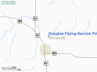
Douglas Flying Service Private Airport |
Location & QuickFacts
| FAA Information Effective: | 2008-09-25 |
| Airport Identifier: | 6TE8 |
| Airport Status: | Operational |
| Longitude/Latitude: | 100-13-01.3800W/33-10-08.3460N
-100.217050/33.168985 (Estimated) |
| Elevation: | 1743 ft / 531.27 m (Surveyed) |
| Land: | 15 acres |
| From nearest city: | 2 nautical miles N of Aspermont, TX |
| Location: | Stonewall County, TX |
| Magnetic Variation: | 08E (1985) |
Owner & Manager
| Ownership: | Privately owned |
| Owner: | Jimmy C. Douglas |
| Address: | Box 478
Aspermont, TX 79502 |
| Phone number: | 817-989-3464 |
| Manager: | J. C. Douglas |
| Address: | Box 478
Aspermont, TX 79502 |
| Phone number: | 817-989-3464 |
Airport Operations and Facilities
| Airport Use: | Private |
| Wind indicator: | Yes |
| Segmented Circle: | No |
| Control Tower: | No |
| Landing fee charge: | No |
| Sectional chart: | Dallas-ft Worth |
| Region: | ASW - Southwest |
| Boundary ARTCC: | ZFW - Fort Worth |
| Tie-in FSS: | FTW - Fort Worth |
| FSS on Airport: | No |
| FSS Phone: | 817-541-3474 |
| FSS Toll Free: | 1-800-WX-BRIEF |
Airport Services
| Fuel available: | 100LL |
| Airframe Repair: | NONE |
| Power Plant Repair: | NONE |
Runway Information
Runway 01/19
| Dimension: | 3455 x 25 ft / 1053.1 x 7.6 m |
| Surface: | GRVL, Poor Condition |
| |
Runway 01 |
Runway 19 |
| Traffic Pattern: | Left | Left |
| Obstruction: | 4 ft fence, 12.0 ft from runway, 3:1 slope to clear
+4' FENCE ACROSS APCH. | 8 ft earth dam, 0.0 ft from runway, 20 ft left of centerline
8' EARTH DAM 10' LEFT OF CNTRLN. |
|
Runway 17/35
| Dimension: | 2190 x 25 ft / 667.5 x 7.6 m |
| Surface: | DIRT, Poor Condition |
| |
Runway 17 |
Runway 35 |
| Traffic Pattern: | Left | Left |
| Obstruction: | 30 ft pline, 1000.0 ft from runway, 33:1 slope to clear | 20 ft shed, 0.0 ft from runway, 50 ft right of centerline
+8' SHED 25' RIGHT OF CNTRLN. |
|
Radio Navigation Aids
| ID |
Type |
Name |
Ch |
Freq |
Var |
Dist |
| AKL | NDB | Haskell | | 407.00 | 08E | 25.0 nm |
| TMV | NDB | Stamford | | 290.00 | 08E | 30.3 nm |
| SWW | NDB | Sweetwater | | 275.00 | 08E | 44.3 nm |
| SDR | NDB | Snyder | | 359.00 | 08E | 46.3 nm |
| DYS | TACAN | Dyess | 063X | | 08E | 48.6 nm |
| GTH | VORTAC | Guthrie | 092X | 114.50 | 10E | 37.1 nm |
| ABI | VORTAC | Abilene | 084X | 113.70 | 10E | 45.0 nm |
Images and information placed above are from
http://www.airport-data.com/airport/6TE8/
We thank them for the data!
| General Info
|
| Country |
United States
|
| State |
TEXAS
|
| FAA ID |
6TE8
|
| Latitude |
33-10-08.346N
|
| Longitude |
100-13-01.380W
|
| Elevation |
1743 feet
|
| Near City |
ASPERMONT
|
We don't guarantee the information is fresh and accurate. The data may
be wrong or outdated.
For more up-to-date information please refer to other sources.
|
|


