 |
|
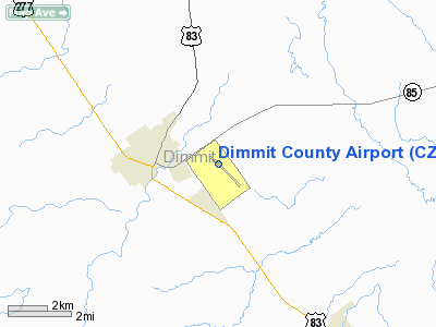
Location & QuickFacts
| FAA Information Effective: | 2008-09-25 |
| Airport Identifier: | CZT |
| Airport Status: | Operational |
| Longitude/Latitude: | 099-49-25.0844W/28-31-20.1042N
-99.823635/28.522251 (Estimated) |
| Elevation: | 599 ft / 182.58 m (Surveyed) |
| Land: | 530 acres |
| From nearest city: | 2 nautical miles E of Carrizo Springs, TX |
| Location: | Dimmit County, TX |
| Magnetic Variation: | 07E (2000) |
Owner & Manager
| Ownership: | Publicly owned |
| Owner: | Dimmit County |
| Address: | Dimmit Co Courthouse
Carrizo Springs, TX 78834 |
| Phone number: | 830-876-2323 |
| Manager: | Ernest Martinez, Sr |
| Address: | 615 Airport Dr.
Carrizo Springs, TX 78834 |
| Phone number: | 830-876-9339
HOME PHONE: 830-876-2967. |
Airport Operations and Facilities
| Airport Use: | Open to public |
| Wind indicator: | Yes |
| Segmented Circle: | Yes |
| Control Tower: | No |
| Lighting Schedule: | DUSK-DAWN |
| Beacon Color: | Clear-Green (lighted land airport) |
| Landing fee charge: | Yes |
| Sectional chart: | San Antonio |
| Region: | ASW - Southwest |
| Boundary ARTCC: | ZHU - Houston |
| Tie-in FSS: | SJT - San Angelo |
| FSS on Airport: | No |
| FSS Toll Free: | 1-800-WX-BRIEF |
| NOTAMs Facility: | SJT (NOTAM-d service avaliable) |
| Federal Agreements: | NGY |
Airport Communications
| CTAF: | 122.800 |
| Unicom: | 122.800 |
Airport Services
| Fuel available: | 100LLA
FUEL SERVICE AVBL ON REQUEST 24 HRS; CALL 830-876-9339/2967. |
| Bottled Oxygen: | NONE |
| Bulk Oxygen: | NONE |
Runway Information
Runway 13/31
| Dimension: | 4997 x 75 ft / 1523.1 x 22.9 m |
| Surface: | ASPH, Good Condition |
| Weight Limit: | Single wheel: 13000 lbs. |
| Edge Lights: | Medium |
| |
Runway 13 |
Runway 31 |
| Longitude: | 099-49-45.2392W | 099-49-04.9315W |
| Latitude: | 28-31-37.2841N | 28-31-02.9235N |
| Elevation: | 599.00 ft | 584.00 ft |
| Alignment: | 127 | 127 |
| Traffic Pattern: | Left | Left |
| Markings: | Non-precision instrument, Fair Condition | Non-precision instrument, Fair Condition |
| VASI: | 2-light PAPI on left side
PAPI OTS INDEFLY. | 2-light PAPI on left side
PAPI OTS INDEFLY. |
| Obstruction: | 31 ft tree, 730.0 ft from runway, 300 ft left of centerline, 17:1 slope to clear | 35 ft pole, 1550.0 ft from runway, 246 ft right of centerline, 38:1 slope to clear |
|
Radio Navigation Aids
| ID |
Type |
Name |
Ch |
Freq |
Var |
Dist |
| DMD | NDB | Dimmit County | | 343.00 | 07E | 0.2 nm |
| LKX | NDB | La Pryor | | 223.00 | 09E | 24.6 nm |
| CPZ | NDB | Chaparrosa Ranch | | 385.00 | 10E | 25.2 nm |
| UVA | NDB | Uvalde | | 281.00 | 07E | 39.7 nm |
| PFO | NDB | Spofford | | 356.00 | 08E | 49.1 nm |
| COT | VORTAC | Cotulla | 105X | 115.80 | 09E | 37.4 nm |
Remarks
Images and information placed above are from
http://www.airport-data.com/airport/CZT/
We thank them for the data!
| General Info
|
| Country |
United States
|
| State |
TEXAS
|
| FAA ID |
CZT
|
| Latitude |
28-31-20.104N
|
| Longitude |
099-49-25.084W
|
| Elevation |
599 feet
|
| Near City |
CARRIZO SPRINGS
|
We don't guarantee the information is fresh and accurate. The data may
be wrong or outdated.
For more up-to-date information please refer to other sources.
|
|


