 |
|
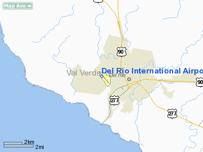
| Del Rio International Airport |
| IATA: DRT – ICAO: KDRT |
| Summary |
| Airport type |
Public |
| Operator |
City of Del Rio |
| Location |
Del Rio, Texas |
| Elevation AMSL |
999 ft / 304 m |
| Coordinates |
29°22′22.20″N 100°55′33.05″W / 29.372833°N 100.9258472°W / 29.372833; -100.9258472Coordinates: 29°22′22.20″N 100°55′33.05″W / 29.372833°N 100.9258472°W / 29.372833; -100.9258472 |
| Runways |
| Direction |
Length |
Surface |
| ft |
m |
| 13/31 |
6,300 |
2,000 |
Asphalt |
Del Rio International Airport (IATA: DRT, ICAO: KDRT) is a public airport located just west of Del Rio, Texas. The airport has a single 6300' runway. The airport is owned by the City of Del Rio with a seven member airport advisory board, appointed by the City Council, monitors the development and operations of the airport. The airport is classified by the FAA as a commercial primary, non-hub airport. Currently the airport terminal is undergoing a 2.7 million dollar expansion to be ready by the fall of 2010, Once completed, The terminal will double in size and will have space for a second commercial airline. Construction is also in progress on the 6,000 sf. Texas Dept. Of Public Safety (DPS) Air Patrol station. Other upcoming airport projects includes an airport control tower, and the expansion of the Federal Express (FedEx) Cargo facility.
DRT is mostly used for general aviation but is also served by Continental airlines (Soon to become United Airlines). Due to its proximity to Laughlin AFB it is often used by USAF pilot training students. The Airport serves the Middle Rio Grande region. Airlines and destinations
| Airlines |
Destinations |
| Continental Connection operated by Colgan Air |
Houston-Intercontinental |
History
The airport opened in November 1937 as Val Verde County Airport. On 26 September 1942, during World War II, the airport was taken over by the United States Army Air Forces and used as a contract primary pilot training airfield under the AAF Gulf Coast Training Center (later Central Flying Training Command). Flying training was performed with Fairchild PT-19s as the primary trainer. Also had several PT-17 Stearmans and a few P-40 Warhawks assigned.
Inactivated 11 January 1946 and airport returned to civil control.
The above content comes from Wikipedia and is published under free licenses – click here to read more.
Location & QuickFacts
| FAA Information Effective: | 2008-09-25 |
| Airport Identifier: | DRT |
| Airport Status: | Operational |
| Longitude/Latitude: | 100-55-37.7650W/29-22-27.1450N
-100.927157/29.374207 (Estimated) |
| Elevation: | 1002 ft / 305.41 m (Estimated) |
| Land: | 268 acres |
| From nearest city: | 2 nautical miles NW of Del Rio, TX |
| Location: | Val Verde County, TX |
| Magnetic Variation: | 08E (2000) |
Owner & Manager
| Ownership: | Publicly owned |
| Owner: | Del Rio/val Verde Cty |
| Address: | 109 W Braodway Street
Del Rio, TX 78840 |
| Phone number: | 830-774-8558
EXT 231. |
| Manager: | Joel C. Martinez |
| Address: | 1104 West 10th Street
Del Rio, TX 78841 |
| Phone number: | 830-774-8538 |
Airport Operations and Facilities
| Airport Use: | Open to public |
| Wind indicator: | Yes |
| Segmented Circle: | Yes |
| Control Tower: | No |
| Lighting Schedule: | DUSK-DAWN
ACTVT MALSR RY 13 - CTAF. |
| Beacon Color: | Clear-Green (lighted land airport) |
| Landing fee charge: | No |
| Sectional chart: | San Antonio |
| Region: | ASW - Southwest |
| Boundary ARTCC: | ZHU - Houston |
| Tie-in FSS: | SJT - San Angelo |
| FSS on Airport: | No |
| FSS Toll Free: | 1-800-WX-BRIEF |
| NOTAMs Facility: | DRT (NOTAM-d service avaliable) |
| Certification type/date: | I A S 02/2005 |
| Federal Agreements: | NGY3 |
Airport Communications
| CTAF: | 122.800 |
| Unicom: | 122.800 |
Airport Services
| Fuel available: | 100LLA |
| Airframe Repair: | MAJOR |
| Power Plant Repair: | MAJOR |
Runway Information
Runway 13/31
| Dimension: | 6300 x 100 ft / 1920.2 x 30.5 m |
| Surface: | ASPH, |
| Weight Limit: | Single wheel: 35000 lbs. |
| Edge Lights: | Medium |
| |
Runway 13 |
Runway 31 |
| Longitude: | 100-56-00.5400W | 100-55-14.9900W |
| Latitude: | 29-22-51.1100N | 29-22-03.1800N |
| Elevation: | 1002.00 ft | 995.00 ft |
| Alignment: | 127 | 127 |
| ILS Type: | LOC/DME
| |
| Traffic Pattern: | Right | Left |
| Markings: | Precision instrument, Good Condition | Non-precision instrument, Good Condition |
| Crossing Height: | 45.00 ft | 45.00 ft |
| Displaced threshold: | 300.00 ft | 0.00 ft |
| VASI: | 4-light PAPI on left side | 4-light PAPI on left side |
| Visual Glide Angle: | 3.00° | 3.00° |
| Approach lights: | MALSR | |
| Runway End Identifier: | | Yes |
| Obstruction: | 16 ft tree, 900.0 ft from runway, 310 ft right of centerline, 44:1 slope to clear
50:1 SLOPE TO THE DSPLCD THLD. | 50 ft tree, 1200.0 ft from runway, 85 ft left of centerline, 20:1 slope to clear |
| Decleard distances: | Take off run available 6300.00 ft
Take off distance available 6300.00 ft
Actual stop distance available 6300.00 ft
Landing distance available 6000.00 ft
| Take off run available 6300.00 ft
Take off distance available 6300.00 ft
Actual stop distance available 6000.00 ft
Landing distance available 6000.00 ft
|
|
Radio Navigation Aids
| ID |
Type |
Name |
Ch |
Freq |
Var |
Dist |
| BRX | NDB | La Fonda Ranch | | 269.00 | 09E | 18.8 nm |
| PFO | NDB | Spofford | | 356.00 | 08E | 29.6 nm |
| DLF | VORTAC | Laughlin | 091X | 114.40 | 07E | 8.2 nm |
Images and information placed above are from
http://www.airport-data.com/airport/DRT/
We thank them for the data!
| General Info
|
| Country |
United States
|
| State |
TEXAS
|
| FAA ID |
DRT
|
| Latitude |
29-22-22.200N
|
| Longitude |
100-55-33.050W
|
| Elevation |
999 feet
|
| Near City |
DEL RIO
|
We don't guarantee the information is fresh and accurate. The data may
be wrong or outdated.
For more up-to-date information please refer to other sources.
|
|


