 |
|
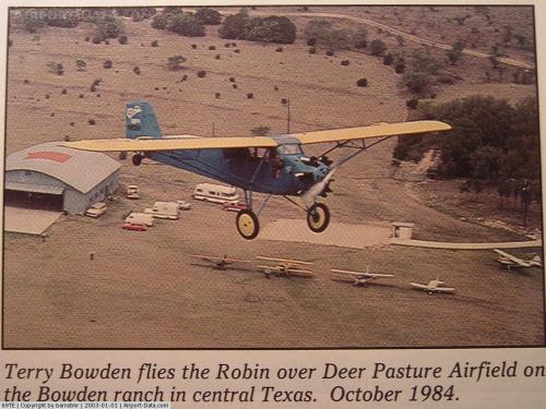 |
(Click on the photo to enlarge) |
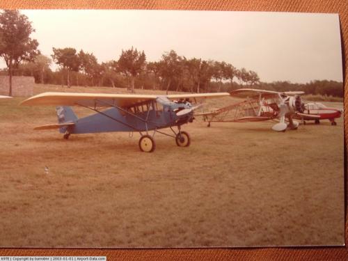 |
(Click on the photo to enlarge) |
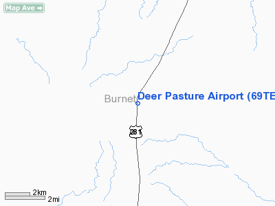
Location & QuickFacts
| FAA Information Effective: | 2008-09-25 |
| Airport Identifier: | 69TE |
| Airport Status: | Operational |
| Longitude/Latitude: | 098-14-11.1010W/30-55-34.6360N
-98.236417/30.926288 (Estimated) |
| Elevation: | 1422 ft / 433.43 m (Estimated) |
| Land: | 0 acres |
| From nearest city: | 9 nautical miles SW of Lampasas, TX |
| Location: | Burnet County, TX |
| Magnetic Variation: | 07E (1985) |
Owner & Manager
| Ownership: | Privately owned |
| Owner: | John R. Bowden |
| Address: | Route 2 Box 137
Lampasas, TX 76550 |
| Phone number: | 512-556-6873 |
| Manager: | John R Bowden Ranch Mgr |
| Address: | Route 2 Box 137
Lampasas, TX 76550 |
| Phone number: | 512-556-6873 |
Airport Operations and Facilities
| Airport Use: | Private |
| Wind indicator: | Yes |
| Segmented Circle: | No |
| Control Tower: | No |
| Landing fee charge: | No |
| Sectional chart: | San Antonio |
| Region: | ASW - Southwest |
| Boundary ARTCC: | ZHU - Houston |
| Tie-in FSS: | SJT - San Angelo |
| FSS on Airport: | No |
| FSS Toll Free: | 1-800-WX-BRIEF |
Airport Services
| Airframe Repair: | NONE |
| Power Plant Repair: | NONE |
Runway Information
Runway 04/22
| Dimension: | 2000 x 75 ft / 609.6 x 22.9 m |
| Surface: | TURF, |
| |
Runway 04 |
Runway 22 |
| Traffic Pattern: | Left | Left |
|
Radio Navigation Aids
| ID |
Type |
Name |
Ch |
Freq |
Var |
Dist |
| BMQ | NDB | Burnet | | 341.00 | 07E | 11.2 nm |
| GR | NDB | Starn | | 323.00 | 07E | 23.5 nm |
| MFS | NDB | Horseshoe Bay Resort | | 403.00 | 07E | 25.0 nm |
| IL | NDB | Iresh | | 278.00 | 07E | 27.9 nm |
| HLR | NDB | Hood | | 347.00 | 07E | 29.7 nm |
| GUO | NDB | Georgetown | | 332.00 | 06E | 32.2 nm |
| MNZ | NDB | Hamilton | | 251.00 | 07E | 42.0 nm |
| GRK | VOR/DME | Gray | 055X | 111.80 | 07E | 22.7 nm |
| TPL | VOR/DME | Temple | 041X | 110.40 | 09E | 45.1 nm |
| LZZ | VORTAC | Lampasas | 072X | 112.50 | 08E | 16.3 nm |
| LLO | VORTAC | Llano | 019X | 108.20 | 08E | 29.5 nm |
| CWK | VORTAC | Centex | 075X | 112.80 | 06E | 49.2 nm |
| STV | VORTAC | Stonewall | 085X | 113.80 | 08E | 49.6 nm |
Images and information placed above are from
http://www.airport-data.com/airport/69TE/
We thank them for the data!
| General Info
|
| Country |
United States
|
| State |
TEXAS
|
| FAA ID |
69TE
|
| Latitude |
30-55-34.636N
|
| Longitude |
098-14-11.101W
|
| Elevation |
1422 feet
|
| Near City |
LAMPASAS
|
We don't guarantee the information is fresh and accurate. The data may
be wrong or outdated.
For more up-to-date information please refer to other sources.
|
|


