|
|
David Wayne Hooks Memorial Airport |
Coordinates: 30°03′43″N 095°33′10″W / 30.06194°N 95.55278°W / 30.06194; -95.55278
| David Wayne Hooks Memorial Airport |
| IATA: DWH – ICAO: KDWH – FAA LID: DWH |
| Summary |
| Airport type |
Public-use, privately-owned |
| Owner |
Jag Gill |
| Serves |
Houston, Texas |
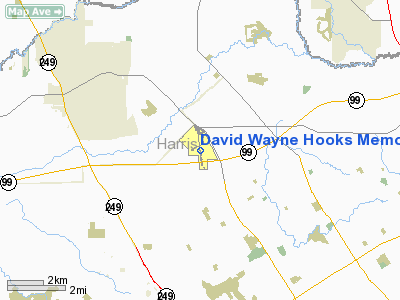
| Location |
Tomball, Texas |
| Elevation AMSL |
152 ft / 46 m |
| Website |
www.hooksairport.com |
| Runways |
| Direction |
Length |
Surface |
| ft |
m |
| 17R/35L |
7,009 |
2,136 |
Asphalt |
| 17L/35R |
3,987 |
1,215 |
Asphalt |
| 17W/35W |
2,530 |
771 |
Water |
| Statistics (2002) |
| Aircraft operations |
223,585 |
| Based aircraft |
300 |
| Source: Federal Aviation Administration |
David Wayne Hooks Memorial Airport (IATA: DWH, ICAO: KDWH, FAA LID: DWH) is a public-use airport located near the city of Tomball in unincorporated Harris County, Texas. It is 23 miles (37 km) northwest of the central business district of Houston. The airport is privately-owned by Jag Gill.
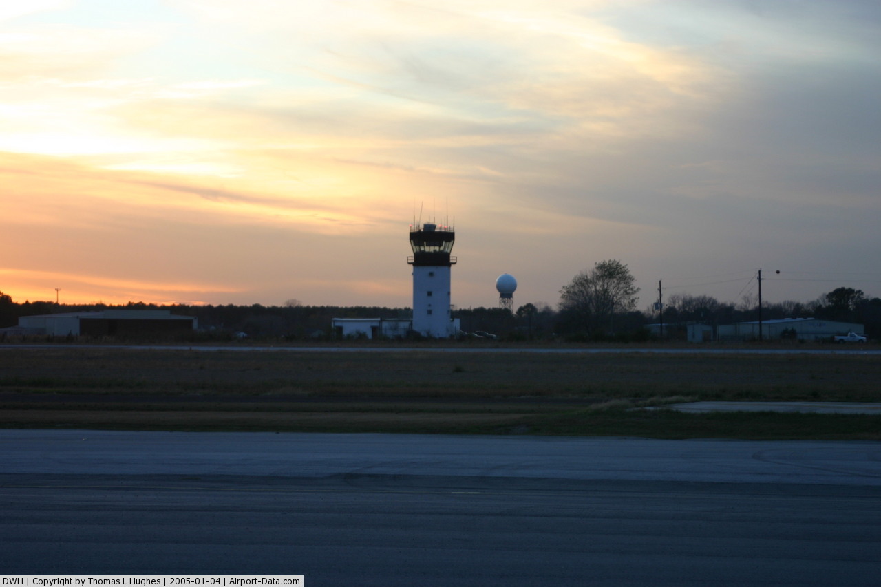
The airport is notable because it is one of only a few privately owned airports with a Federal Aviation Administration control tower; the airport is owned by Jag Gill and managed by Robert Schmidt.
On June 27, 2007, The Texas State Legislature approved Tomball's request to annex Hooks Airport even though the airport does not border the Tomball city limits. Since the airport is in the city of Houston's extraterritorial jurisdiction, the city of Tomball must get permission from Houston to annex the airport. As of summer of 2010, the annex still has not been finalized. Facilities and aircraft
David Wayne Hooks Memorial Airport covers an area of 480 acres (194 ha) which contains two asphalt paved runways: 17R/35L measuring 7,009 x 100 ft (30 m). and 17L/35R measuring 3,987 x 35 ft (1,215 x 11 m). It also has a seaplane landing area designated as runway 17W/35W which is 2,530 x 100 ft (771 x 30 m).
For the 12-month period ending August 5, 2002, the airport had 223,585 aircraft operations, an average of 612 per day: 98% general aviation, 1% air taxi and 1% military. There are 300 aircraft based at this airport: 83% single-engine, 10% multi-engine, 3% jet and 4% helicopter.
Facilities include:
-The main Gill Aviation terminal
-The Aviator Grill, a locally owned and operated restaurant connected to the Gill Aviation terminal. The grill is a popular community restaurant, and provides a spectacular view of the main ramps and runway 17R.
-Tomball Jet Center
-Helicopter Services
-LifeFlight Alert center, with Memorial Herman Hosptial operated LifeFlight 4 on permanent standby.
The airport also includes numerous flight schools, including Silver State Helicopters and American Flyers.
The airport is also a local favorite for its diverse mix of aircraft and openness. The main ramps and taxiways, while monitored by airport staff, lack the usual high, barbed-wire fences, and families and enthusiasts are able to relax by the lake and grassy areas just mere feet from where aircraft are parked and operating from. Visiting aircraft range from standard GA traffic to exotic military aircraft such as the MV-22 Osprey and the F/A-18E Super Hornet that can turn a lazy day into a spontaneous gathering of like minded people within moments, and military pilots are often more than willing to give visitors up close and personal looks at their aircraft.
HistoryThe Airport started when Charles Hooks built a runway for his own personal use. His hobby eventually became a business, and he subsequently built a runway and a main terminal building. It was first opened for public use in the 1960s. Shortly after its opening, Hooks' son, David, was killed in the crash of a small plane that he was piloting under the supervision of a flight instructor. All four people on the plane were killed. David was about 16 years old at the time of his death. The airport's name was changed from Houston Northwest Airport to David Wayne Hooks Memorial Airport in his memory.
Until the 1980s, the airport was run and maintained by Hooks, and his wife Irma. Upon the death of Mrs. Hooks, her daughter stepped in and helped with its operation.
In 1989, Charles Hooks retired and sold the airport to the Gill Family.
In 2009 a fire occurred at the airport. A man was burned, and several aircraft were destroyed.
On June 26, 2010, another fire occurred at the airport, destroying another large hanger. One helicopter and several aircraft components were destroyed.
In early 2010, Hooks Airport received a notable resident when the B-17G Flying Fortress 'Texas Raiders' was permanently moved from William P. Hobby Airport to a spacious hanger in the Tomball Jet Center as a cost saving measure. 'Texas Raiders' will use Hooks Airport as her base of operations for the 2010 air show season and into the foreseeable future.
The above content comes from Wikipedia and is published under free licenses – click here to read more.
 |
(Click on the photo to enlarge) |
Location & QuickFacts
| FAA Information Effective: | 2008-09-25 |
| Airport Identifier: | DWH |
| Airport Status: | Operational |
| Longitude/Latitude: | 095-33-10.0000W/30-03-42.6000N
-95.552778/30.061833 (Estimated) |
| Elevation: | 152 ft / 46.33 m (Surveyed) |
| Land: | 480 acres |
| From nearest city: | 17 nautical miles NW of Houston, TX |
| Location: | Harris County, TX |
| Magnetic Variation: | 05E (2000) |
Owner & Manager
| Ownership: | Privately owned |
| Owner: | Jag Gill
NORTHWEST ARPT MANAGEMENT, L.P. |
| Address: | Po Box 1509
Tomball, TX 77377-1509 |
| Phone number: | 281-376-5436 |
| Manager: | Roger Schmidt |
| Address: | 20803 Steubner Airline, Nr 0
Spring, TX 00773-1509 |
| Phone number: | 281-376-5436 |
Airport Operations and Facilities
| Airport Use: | Open to public |
| Wind indicator: | Yes |
| Segmented Circle: | Yes |
| Control Tower: | Yes |
| Lighting Schedule: | DUSK-DAWN
WHEN ATCT CLSD ACTVT HIRL RY 17R/35L, REIL RY 17R - 118.4. |
| Beacon Color: | Clear-Green (lighted land airport) |
| Landing fee charge: | No |
| Sectional chart: | Houston |
| Region: | ASW - Southwest |
| Traffic Pattern Alt: | 1000 ft |
| Boundary ARTCC: | ZHU - Houston |
| Tie-in FSS: | CXO - Montgomery County |
| FSS on Airport: | No |
| FSS Toll Free: | 1-800-WX-BRIEF
FOR FP FILING CALL CXO FSS 1-800-833-5602 |
| NOTAMs Facility: | DWH (NOTAM-d service avaliable) |
| Federal Agreements: | NB |
Airport Communications
| CTAF: | 118.400 |
| Unicom: | 122.950 |
Airport Services
| Fuel available: | 100LLA |
| Airframe Repair: | MAJOR |
| Power Plant Repair: | MAJOR |
| Bulk Oxygen: | LOW |
Runway Information
Runway 17L/35R
| Dimension: | 3987 x 35 ft / 1215.2 x 10.7 m |
| Surface: | ASPH, Poor Condition |
| Weight Limit: | Single wheel: 4000 lbs. |
| |
Runway 17L |
Runway 35R |
| Longitude: | 095-33-08.6866W | 095-33-03.0389W |
| Latitude: | 30-03-50.1370N | 30-03-10.9825N |
| Elevation: | 150.00 ft | 144.00 ft |
| Alignment: | 127 | 127 |
| Traffic Pattern: | Left | Right |
| Markings: | Basic, Poor Condition
17L/35R MARKINGS FADED. | Basic, Poor Condition |
| Displaced threshold: | 0.00 ft | 208.00 ft |
| Obstruction: | , 50:1 slope to clear | 44 ft trees, 640.0 ft from runway, 10:1 slope to clear
APCH RATIO 19:1 FM DSPLCD THLD OVER 44 FT TREES AT 860 FT FM DSPLCD THLD 0B. |
|
Runway 17R/35L
| Dimension: | 7009 x 100 ft / 2136.3 x 30.5 m |
| Surface: | ASPH, Fair Condition |
| Weight Limit: | Single wheel: 30000 lbs.
Dual wheel: 85000 lbs. |
| Edge Lights: | High |
| |
Runway 17R |
Runway 35L |
| Longitude: | 095-33-17.3279W | 095-33-07.2668W |
| Latitude: | 30-04-23.9281N | 30-03-15.1018N |
| Elevation: | 150.00 ft | 145.00 ft |
| Alignment: | 127 | 127 |
| ILS Type: | LOC/DME
| |
| Traffic Pattern: | Left | Left |
| Markings: | Non-precision instrument, Good Condition | Non-precision instrument, Good Condition |
| Crossing Height: | 0.00 ft | 45.00 ft |
| Displaced threshold: | 1007.00 ft | 0.00 ft |
| VASI: | 4-light PAPI on right side | 4-light PAPI on left side |
| Visual Glide Angle: | 0.00° | 3.00° |
| Runway End Identifier: | Yes
REIL LOCATED AT DSPLCD THR. REIL OTS INDEFLY. | Yes |
| Obstruction: | 15 ft road, 200.0 ft from runway, 125 ft left of centerline
APCH RATIO 39:1 FM DSPLCD THLD TO 54 FT TREES 2150 FT FM DSPLCD THLD ACROSS APCH.
DIRT ROAD ON CNTRLN 175 FT FM THLD. | 27 ft trees, 525.0 ft from runway, 275 ft left of centerline, 12:1 slope to clear |
| Decleard distances: | Take off run available 7009.00 ft
Take off distance available 7009.00 ft
Actual stop distance available 7009.00 ft
Landing distance available 6012.00 ft
| Take off run available 6700.00 ft
Take off distance available 6700.00 ft
Actual stop distance available 6700.00 ft
Landing distance available 6700.00 ft
|
|
Runway 17W/35W
| Dimension: | 2530 x 100 ft / 771.1 x 30.5 m |
| Surface: | WATER, |
| |
Runway 17W |
Runway 35W |
| Traffic Pattern: | Left | Right |
| Obstruction: | 10 ft berm | 4 ft berm, 0.0 ft from runway |
|
Radio Navigation Aids
| ID |
Type |
Name |
Ch |
Freq |
Var |
Dist |
| DWH | NDB | David Hooks | | 521.00 | 05E | 3.9 nm |
| EYQ | NDB | Weiser | | 286.00 | 06E | 9.0 nm |
| LYD | NDB | Lakeside | | 249.00 | 05E | 16.1 nm |
| BVP | NDB | Nixin | | 326.00 | 05E | 18.1 nm |
| SGR | NDB | Hull | | 388.00 | 05E | 26.4 nm |
| SYG | NDB | Sandy Point | | 402.00 | 05E | 33.9 nm |
| JPA | NDB | Sanjac | | 347.00 | 05E | 34.5 nm |
| UTS | NDB | Huntsville | | 308.00 | 06E | 40.9 nm |
| BNH | NDB | Brenham | | 362.00 | 06E | 43.7 nm |
| CBC | NDB | Anahuac | | 413.00 | 05E | 49.5 nm |
| EFD | TACAN | Ellington | 031X | | 05E | 34.2 nm |
| HUB | VOR/DME | Hobby | 118X | 117.10 | 05E | 28.3 nm |
| ELA | VOR/DME | Eagle Lake | 111X | 116.40 | 08E | 46.5 nm |
| IAH | VORTAC | Humble | 113X | 116.60 | 05E | 12.5 nm |
| TNV | VORTAC | Navasota | 106X | 115.90 | 08E | 29.6 nm |
| DAS | VORTAC | Daisetta | 116X | 116.90 | 05E | 47.8 nm |
| HOU | VOT | Houston Wm P Hobby | | 108.40 | | 28.8 nm |
Remarks
- TWYS UNLGTD.
- TWYS A & B CLSD EAST OF RY 17R INDEFLY.
- ACFT 12,499 LBS AND OVER ARE RSTD TO TWYS C, P, TWY E (BTN TWY P & G), TWY G (NORTH OF TWY E), RAMPS A & C AND THE TOMBALL JET CENTER RAMP.
- NOISE SENSITIVE AREA SW OF ARPT. ALL MILITARY ACFT DEPARTING RY 17R CLIMB RY HEADING TO 650 FT MSL PRIOR TO TURNS OR REJOIN.
- AFT SUNSET LARGE ACFT USE TWY P BTN TWYS E & C.
- HELICOPTER PRACTICE AREA WEST OF ATCT AT OR BLO 600 FT.
- RY 17R/35L LGTD SIGNS OTS INDEFLY.
- TWY H LGTD SIGNS OTS INDEFLY.
- AFT HRS SVC AVBL; PRIOR NOTICE REQUIRED DURG ATNDD HRS CTC 1-800-624-7394; C281-376-5436.
- FOUR HELICOPTER PARKING SPOTS LCTD EAST OF TWY K.
- TWY K RESTRICTED TO PISTON ACFT ONLY.
Images and information placed above are from
http://www.airport-data.com/airport/DWH/
We thank them for the data!
| General Info
|
| Country |
United States
|
| State |
TEXAS
|
| FAA ID |
DWH
|
| Latitude |
30-03-42.700N
|
| Longitude |
095-33-10.000W
|
| Elevation |
152 feet
|
| Near City |
HOUSTON
|
We don't guarantee the information is fresh and accurate. The data may
be wrong or outdated.
For more up-to-date information please refer to other sources.
|
|