 |
|
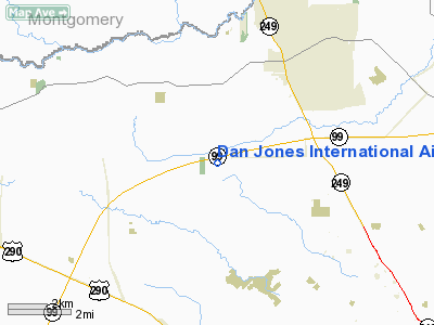
| Dan Jones International Airport |
| IATA: none – ICAO: none – FAA LID: T51 |
| Summary |
| Airport type |
Public |
| Owner |
Daniel Jones |
| Serves |
Houston, Texas |
| Location |
Tomball, Texas |
| Elevation AMSL |
166 ft / 51 m |
| Coordinates |
30°02′34″N 095°40′02″W / 30.04278°N 95.66722°W / 30.04278; -95.66722 |
| Runways |
| Direction |
Length |
Surface |
| ft |
m |
| 17/35 |
3,440 |
1,049 |
Asphalt/Turf |
| Statistics (2008) |
| Aircraft operations |
7,800 |
| Based aircraft |
18 |
| Source: Federal Aviation Administration |
Dan Jones International Airport (FAA LID: T51) is a public-use airport in unincorporated Harris County, Texas, United States that is privately owned by Daniel Jones of Cypress. The airport is located 5 nautical miles (9 km) southwest of the city of Tomball and 22 nautical miles (41 km) northwest Houston.
Facilities and aircraft
Dan Jones International Airport covers an area of 24 acres (10 ha) at an elevation of 166 feet (51 m) above mean sea level. It has one runway designated 17/35 with a 3,440 by 50 ft (1,049 x 15 m) asphalt and turf surface. For the 12-month period ending May 20, 2008, the airport had 7,800 aircraft operations, an average of 21 per day, all of which were general aviation. At that time there were 18 aircraft based at this airport: 94% single-engine and 6% multi-engine.
The above content comes from Wikipedia and is published under free licenses – click here to read more.
Location & QuickFacts
| FAA Information Effective: | 2008-09-25 |
| Airport Identifier: | T51 |
| Airport Status: | Operational |
| Longitude/Latitude: | 095-40-02.0030W/30-02-33.9910N
-95.667223/30.042775 (Estimated) |
| Elevation: | 166 ft / 50.60 m (Surveyed) |
| Land: | 24 acres |
| From nearest city: | 22 nautical miles NW of Houston, TX |
| Location: | Harris County, TX |
| Magnetic Variation: | 05E (2000) |
Owner & Manager
| Ownership: | Privately owned |
| Owner: | Daniel Jones |
| Address: | 16434 Kitzmann
Magnolia, TX 77354 |
| Phone number: | 281-259-3700 |
| Manager: | Daniel Jones |
| Address: | 16434 Kitzman
Magnolia, TX 77354 |
| Phone number: | 281-732-5552 |
Airport Operations and Facilities
| Airport Use: | Open to public |
| Wind indicator: | Yes |
| Segmented Circle: | No |
| Control Tower: | No |
| Lighting Schedule: | PHONE REQ
FOR ROTG BCN CALL 281-351-9151. |
| Beacon Color: | Clear-Green (lighted land airport) |
| Sectional chart: | Houston |
| Region: | ASW - Southwest |
| Boundary ARTCC: | ZHU - Houston |
| Tie-in FSS: | CXO - Montgomery County |
| FSS on Airport: | No |
| FSS Toll Free: | 1-800-WX-BRIEF
FOR FP FILING CALL CXO FSS 1-800-992-7433. |
| NOTAMs Facility: | CXO (NOTAM-d service avaliable) |
Airport Communications
| CTAF: | 122.800 |
| Unicom: | 122.800 |
Airport Services
Runway Information
Runway 17/35
| Dimension: | 3440 x 50 ft / 1048.5 x 15.2 m |
| Surface: | ASPH-TURF, Fair Condition
NORTH END 1904' X 30' ASPH. |
| Edge Lights: | Non-standard lighting system
RY 17/35 NSTD LIRL; SINGLE THLD LGT EACH RY END. 2240 FT OF RY USABLE FOR NIGHT OPNS. RY 17 THLD RELCTD 300 FT FOR NIGHT OPNS; RY 35 THLD RELCTD 900 FT FOR NIGHT OPNS. |
| |
Runway 17 |
Runway 35 |
| Longitude: | 095-40-02.1560W | 095-40-01.7940W |
| Latitude: | 30-02-50.9960N | 30-02-16.9470N |
| Elevation: | 161.00 ft | 166.00 ft |
| Alignment: | 127 | 127 |
| Traffic Pattern: | Left | Left |
| Markings: | Numbers only, Poor Condition
NRS 10 FT TALL. | , |
| Displaced threshold: | 255.00 ft
THLD DSPLCD 255 FT DAYS ONLY. | 400.00 ft
RY 35 THLD DSPLCD 400 FT DAYS ONLY. |
| Obstruction: | 23 ft tree, 245.0 ft from runway, 50 ft left of centerline, 2:1 slope to clear
APCH RATIO FM DSPLCD THLD 0:1; FM +4 FT FENCE & 15-30 FT TREES 53 FT L OF DSPLCD THLDS.
4 FT FENCE AT THLD 53 FT L & ACROSS APCH 15 FT FM THLD. | 21 ft pline, 10.0 ft from runway
APCH RATIO FM DAY DSPLCD THR 0:1; FM +4' FCS 53' R OF DSPLCD THRS. |
|
Radio Navigation Aids
| ID |
Type |
Name |
Ch |
Freq |
Var |
Dist |
| EYQ | NDB | Weiser | | 286.00 | 06E | 6.7 nm |
| DWH | NDB | David Hooks | | 521.00 | 05E | 7.2 nm |
| LYD | NDB | Lakeside | | 249.00 | 05E | 13.6 nm |
| BVP | NDB | Nixin | | 326.00 | 05E | 23.7 nm |
| SGR | NDB | Hull | | 388.00 | 05E | 24.7 nm |
| SYG | NDB | Sandy Point | | 402.00 | 05E | 34.1 nm |
| BNH | NDB | Brenham | | 362.00 | 06E | 38.3 nm |
| JPA | NDB | Sanjac | | 347.00 | 05E | 38.4 nm |
| UTS | NDB | Huntsville | | 308.00 | 06E | 42.1 nm |
| EFD | TACAN | Ellington | 031X | | 05E | 37.3 nm |
| HUB | VOR/DME | Hobby | 118X | 117.10 | 05E | 30.9 nm |
| ELA | VOR/DME | Eagle Lake | 111X | 116.40 | 08E | 40.9 nm |
| IAH | VORTAC | Humble | 113X | 116.60 | 05E | 17.5 nm |
| TNV | VORTAC | Navasota | 106X | 115.90 | 08E | 25.1 nm |
| IDU | VORTAC | Industry | 039X | 110.20 | 08E | 46.9 nm |
| HOU | VOT | Houston Wm P Hobby | | 108.40 | | 31.3 nm |
Remarks
- ARPT CLSD TO HELICOPTER OPERATIONS.
- RY 17/35 4 FT FENCE 53 FT EAST OF CNTRLN.
- DEER ON RYS.
- NORTH-SOUTH TRANSITIONAL ACFT WEST OF FIELD.
- LEFT HAND TFC 500 FT & 1000 FT MSL.
- CATTLE INVOF RY.
- PRVDD RWY 36 THR LCTD AT OR DSPLCD TO A POINT LCTD FAR ENOUGH FROM PLINE TO PRVD 20:1 APCH.
Images and information placed above are from
http://www.airport-data.com/airport/T51/
We thank them for the data!
| General Info
|
| Country |
United States
|
| State |
TEXAS
|
| FAA ID |
T51
|
| Latitude |
30-02-33.991N
|
| Longitude |
095-40-02.003W
|
| Elevation |
166 feet
|
| Near City |
HOUSTON
|
We don't guarantee the information is fresh and accurate. The data may
be wrong or outdated.
For more up-to-date information please refer to other sources.
|
|


