|
|
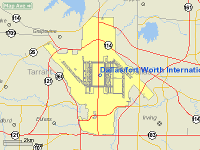
Dallas/fort Worth Intl Airport |
|
|
| Dallas/Fort Worth International Airport |
 |
 |
| IATA: DFW – ICAO: KDFW – FAA LID: DFW
Location of the Dallas/Fort Worth International Airportt
|
| Summary |
| Airport type |
Public |
| Owner |
City of Dallas
City of Fort Worth
|
| Operator |
DFW Airport Board |
| Serves |
Dallas / Fort Worth |
| Location |
Coppell, Euless, Grapevine, and Irving |
| Hub for |
- American Airlines
- UPS Airlines
|
| Elevation AMSL |
607 ft / 185 m |
| Coordinates |
32°53′49″N 097°02′17″W / 32.89694°N 97.03806°W / 32.89694; -97.03806Coordinates: 32°53′49″N 097°02′17″W / 32.89694°N 97.03806°W / 32.89694; -97.03806 |
| Website |
www.dfwairport.com |
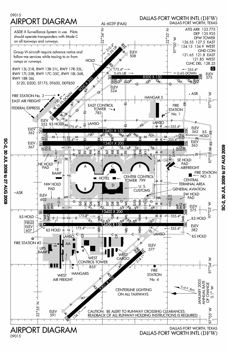
| Runways |
| Direction |
Length |
Surface |
| ft |
m |
| 13L/31R |
9,000 |
2,743 |
Concrete |
| 13R/31L |
9,301 |
2,835 |
Concrete |
| 17C/35C |
13,401 |
4,085 |
Concrete |
| 17L/35R |
8,500 |
2,591 |
Concrete |
| 17R/35L |
13,401 |
4,085 |
Concrete |
| 18L/36R |
13,400 |
4,084 |
Concrete |
| 18R/36L |
13,400 |
4,084 |
Concrete |
| Helipads |
| Number |
Length |
Surface |
| ft |
m |
| H1 |
158 |
48 |
Concrete |
| Statistics (2009) |
| Passengers |
56 030 457 (8th) (+1.9%) |
| Aircraft operations |
638 782 (3rd) (+2.7%) |
| Sources: Airports Council International
|
Dallas/Fort Worth International Airport (IATA: DFW, ICAO: KDFW, FAA LID: DFW) is located between the cities of Dallas and Fort Worth, Texas, and (at least as of 2007) is the busiest airport in the U.S. state of Texas. It generally serves the larger Dallas–Fort Worth metropolitan area, with carriers providing regional, national and international flights.
With 638,782 aircraft movements in 2009, it is the third busiest airport in the world in terms of aircraft movements. In terms of passenger traffic, it is the eighth busiest airport in the world transporting 56,030,457 passengers in 2009.
In terms of land area, at 18,076 acres (7,315 ha), it is the largest airport in Texas, the second largest in the United States, behind Denver International Airport, and fourth largest in the world. It is the ninth busiest international gateway in the United States, and second in Texas, behind George Bush Intercontinental Airport.
It has the most non-intersecting runways with 7. Only Chicago O'Hare International Airport comes close with 7 intersecting runways. In 2006 the airport was named the "Best Cargo Airport in the World" according to the second edition of a survey.
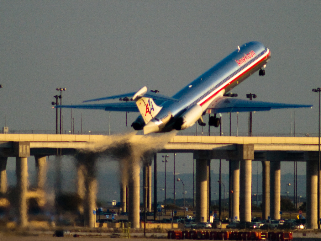
The airport, within the incorporated cities of Coppell, Euless, Grapevine, and Irving, serves 138 domestic destinations and 38 international, and is the largest and primary hub for American Airlines (745 daily flights), and also the primary hub for American Eagle. Eighty five percent of all flights at Dallas/Fort Worth are operated by American Airlines. Delta Air Lines eliminated its Dallas/Fort Worth hub in February 2005 in an effort to cut costs and avoid direct competition with American. The airline shrank operations from 256 daily nonstop flights to 21.
The airport is often referred to by its IATA airport code, "DFW." It is operated in many ways like a small city: it has its own post office, ZIP code, and public services. The United States Postal Service gave the airport its own city designation, DFW Airport, TX. The members of the airport's Board of Directors are appointed by the "owner cities" of Dallas and Fort Worth. The airport is inside the city limits of four suburban cities, a situation that has led to legal battles over jurisdiction (see below). To help ensure future harmony with its neighbors, the DFW Airport Board includes a non-voting member — a representative chosen from the airport's neighbors (Irving, Euless, Grapevine, and Coppell) on a rotating basis. HistoryAs early as 1927, before the area had an airport, Dallas proposed a joint airport with Fort Worth. Fort Worth declined the offer, and thus the two cities opened their own airports, Love Field and Meacham Field. Both airports had scheduled airline service.
In 1940, the Civil Aeronautics Administration earmarked $1.9 million for the construction of a Dallas/Fort Worth Regional Airport. American Airlines and Braniff Airways struck a deal with the city of Arlington to build an airport there, but the governments of Dallas and Fort Worth disagreed over its construction and the project was abandoned in 1942. After World War II, Fort Worth annexed the site and developed it into Amon Carter Field with the help of American Airlines.
Fort Worth transferred its commercial flights from Meacham Field to the new airport in 1953, which was just now 12 miles (19 km) from Dallas Love Field.
In 1960, Fort Worth purchased Amon Carter Field and renamed it Greater Southwest International Airport GSW in an attempt to compete with Dallas' more successful airport. However, GSW's traffic continued to decline relative to Dallas Love Field. By the mid-1960s, Fort Worth was getting 1% of Texas air traffic while Dallas was getting 49%, which led to the virtual abandonment of GSW. The joint airport proposal was revisited in 1961 after the FAA refused to invest any more money in separate Dallas and Fort Worth airports. Although the Fort Worth airport was eventually abandoned, Dallas Love Field became congested and had no more room to expand. Following an order from the federal government in 1964 that they would unilaterally choose a site if both cities could not come to an agreement on a site, officials from the two cities finally agreed on a location for a new regional airport that was north of the abandoned GSW and almost perfectly equidistant from the two city centers. The land was purchased by both cities in 1966, and construction began in 1969.
The first landing of a supersonic BAC/Sud (now BAE Systems and Aerospatiale) Concorde in the United States occurred at DFW Airport in 1973 to commemorate the airport's completion. Concorde later served DFW from 1979–1980 in a cooperative agreement between Braniff Airways, British Airways, and Air France. Braniff ended the service due to low load factors. Braniff was the largest airline to open D/FW in 1974 with a full semicircular terminal designated 2W ( now Terminal B) devoted to its operations. Other airlines, like American Airlines, only had half a terminal or less. DFW Airport opened for commercial service on January 13, 1974. The original name was Dallas/Fort Worth Regional Airport. The name change to Dallas/Fort Worth International did not occur until 1985. Following the Wright Amendment of 1979, which banned long-distance flights from Love Field, DFW became the only airport in the metropolitan area to offer long-haul commercial air passenger service on aircraft with more than 56 passenger seats. American established its first hub at DFW on June 11, 1981, adding flights to London in 1982, and Tokyo in 1987. American Airlines finished moving its headquarters from Grand Prairie, Texas to a building in Fort Worth located near DFW Airport on January 17, 1983; the airline began leasing the facility from the airport, which owns the facility. Braniff International already had International service to South America and Mexico in 1974, London in 1978 and Europe and Asia in 1979. Delta Air Lines built up a hub at DFW during the same period but announced closure in 2004 in a restructuring of the airline to avoid bankruptcy. Today, Delta only flies from DFW to its 7 hubs.
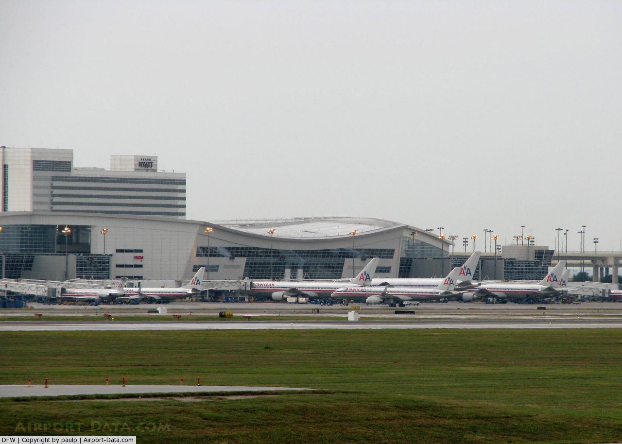
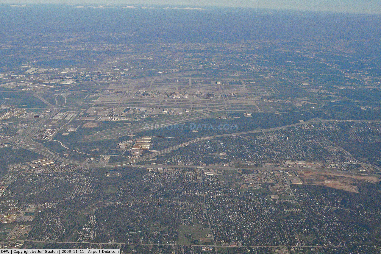
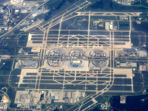
 | |
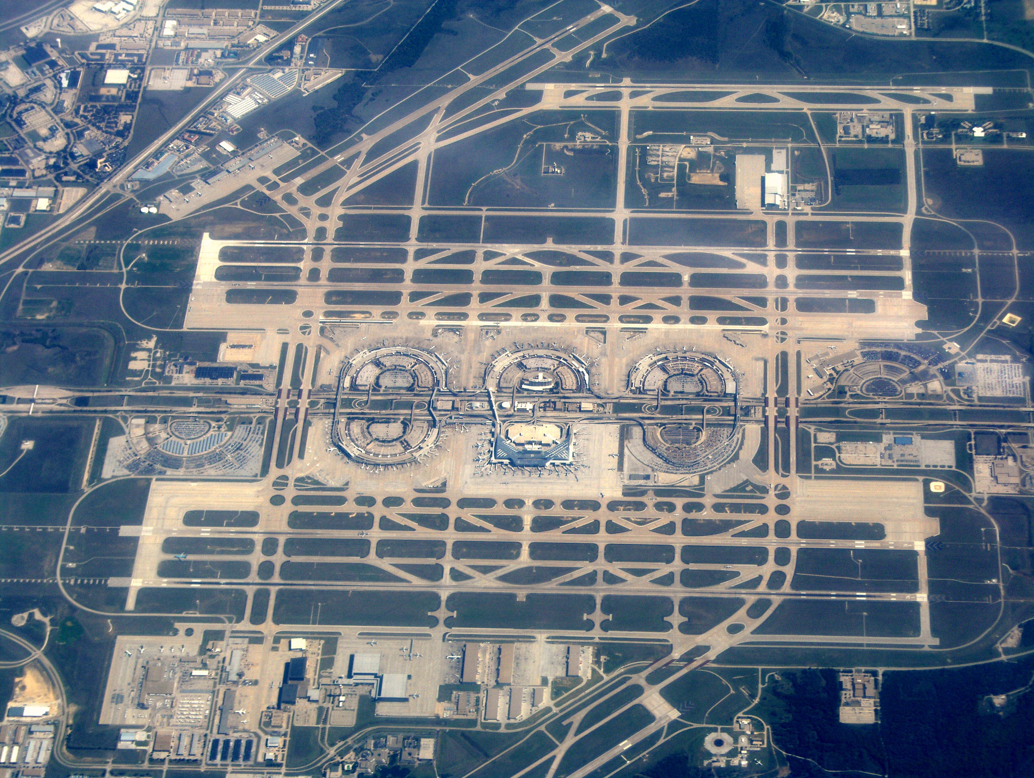
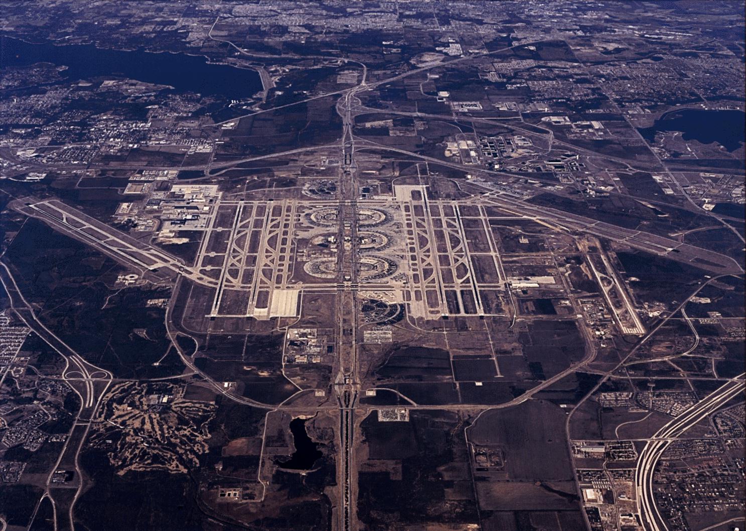
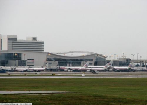
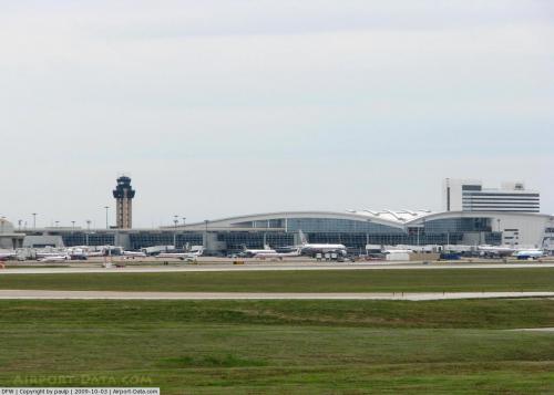
Aerial view of DFW |
After the closing of Delta's hub in 2005, DFW Airport offered incentives to Southwest Airlines to relocate its hub to DFW from Love Field. Southwest, like in the past, chose to stay at Love Field. In 1989, the airport authority announced plans to rebuild the existing terminals and construct 2 new runways. After an environmental impact study was released the following year, the cities of Irving, Euless, and Grapevine sued the airport over its extension plans, a battle that was finally decided (in favor of the airport) by the US Supreme Court in 1994. The seventh runway opened in 1996. The 4 primary North-South runways (those closest to the terminals) were all lengthened from 11,388 feet (3,471 m) to their current length of 13,400 feet (4,084 m). The first of these, 17R/35L, was extended in 1996 (at the same time the new runway was constructed), and the other three (17C/35C, 18L/36R, and 18R/36L) were extended in 2005. DFW is now the only airport in the world with 4 serviceable paved runways longer than 4,000 metres (13,123 ft).
Terminal D, built for international service operations, and Skylink, a modern people mover system, opened in 2005.
Terminals, airlines and destinations
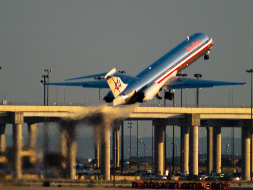 | |
An American Airlines MD80 departing DFW. |
Dallas/Fort Worth International Airport has five terminals. The airport is designed with expansion in mind, and can theoretically accommodate up to thirteen terminals totaling 260 gates, although this level of expansion is unlikely to be reached in the foreseeable future.
The terminals at DFW are semicircular (except for the newest terminal, Terminal D, which is a "square U" shape) and built around the airport's central north-south arterial road, Spur 97, also known as "International Parkway." Until the late 1990s, they were designated by a number (2 being northernmost, 4 being southernmost) and a letter suffix ("E" for East, "W" for West). This system was later scrapped, and the terminals are now lettered from A to E. Terminals A, C, and E (from north to south) are on the east side of the airport, while Terminals B and D (from north to south) are on the west side.
DFW's terminals are designed to minimize the distance between a passenger's car and airplane as well as reduce traffic around terminals. A consequence of this layout is that connecting passengers had to walk extremely long distances between gates (in order to walk from one end of the semicircular concourse to the other, one must walk the entire length; there were no shortcuts between the ends). The original people mover train (Airtrans APM) which opened with the airport was notoriously slow (17 mph (27 km/h)), uni-directional (running only in a counter-clockwise direction), and was located outside the secured area (thus requiring travelers to go through the security process again). It was replaced by SkyLink in April 2005 after serving approximately 250 million passengers. Skylink serves all five terminals at a considerably higher speed, is bi-directional, and is located inside the secured area.
It was reported on August 31, 2009 that DFW Airport officials plan to have four airport terminals revamped. Terminals A, B, C and E are in the plans to receive an estimated $3 billion revamp that would take until 2017 to complete.
Terminal A
American Airlines and its regional affiliate American Eagle have a large presence at Dallas/Fort Worth. The world's second largest airline, in terms of passengers transported, operates its largest hub at DFW. The two airlines operate at four of the five terminals at the airport. Terminal A, previously called "Terminal 2E" when the airport was first opened, is fully occupied by American Airlines for domestic flights. Prior to the opening of Terminal D, Terminal A operated most of AA's international flights at the airport. During the late 1990s, a significant number of American Eagle flights moved to Terminal B. Also in the late 1990s, American Eagle built a Satellite Terminal (Named Satellite Terminal A2) due to the lack of aircraft gates. It was located near Terminal A and was only accessible via shuttle buses. Satellite Terminal A2 (Gates A2A–A2N) was abandoned in 2005 when American Eagle moved all operations to Terminals B and D. However there are plans underway to redevelop the aging Terminal into a world class hub larger and more exclusive than international Terminal D into becoming American Airlines exclusive Central Terminal.
Terminal A has 31 gates: A9–A26, A28–A29, A33–A39
Terminal B
This terminal was originally called "Terminal 2W" when the airport first opened. It was formerly occupied by Braniff International Airways which was the largest carrier to open D/FW in 1974. Braniff Airways was its main occupant until May 1982. An "Inter-Faith" Chapel near United's former gates commemorate the airline. American Eagle occupies 32 gates at Terminal B. Midwest Airlines, US Airways, and United Airlines relocated to Terminal E in July 2006. That all changed on December 13, 2009 when United moved to Terminal E to join its new Alliance partner – Continental. At that point AA is now the sole operator in Terminals A, B, and C. Prior to the opening of Terminal D, all non-AA international flights operated from this terminal.
Terminal B has 35 gates: B3–B30, B33–B39
Terminal C
American Airlines operates all the gates at Terminal C, originally called "Terminal 3E" for only domestic flights.
Terminal C has 31 gates: C2–C4, C6–C8, C10–C12, C14–C17, C19–C22, C24–C33, C35–C37, C39
International Terminal D
International Terminal D designed by HKS, HNTB and Corgan Associates, with Austin Commercial serving as Construction Manager at Risk opened in July 2005. The new terminal is a 2,000,000 sq ft (186,000 m) facility capable of handling 32,000 passengers daily or 11.7 million passengers annually, with 29 gates and an integrated 298-room Grand Hyatt DFW [2] Hotel. The terminal features 200 ticketing positions and a federal inspection facility capable of processing 2,800 passengers per hour. The concession areas consist of 100,000 sq ft (9,290 m) of retail, including many dining and retail options. Stores include Mont Blanc, La Bodega Wines, Brookstone, L'Occitane and many others.
A Hyatt hotel is directly connected to the terminal. Additionally, overnight guests at the hotel who are not flying can obtain a pass to enter the concourses to visit shops and restaurants. Called the Airport Access Authorization to Commercial Establishments Beyond the Screen Checkpoint (AAACE), registered guests must undergo thorough background checks to pass through security. Detroit Metropolitan Wayne County Airport is the only other airport participating in this program. International Terminal DThe new eight-level parking garage has over 8,100 parking spaces and uses a Smart Technology System that lets guests know which floors are full. Air-conditioned skybridges with moving walkways and elevators connect the garage to the terminal, and an arrivals canopy roof shields pedestrians from inclement weather as they enter and exit the terminal.
Terminal D has 29 gates: D6–D8, D10–D12, D14–D18, D20–D25, D27–D31, D33–D34, D36–D40
Terminal E
Terminal E, originally called Terminal 4E, was occupied primarily by Delta Air Lines until Delta closed its hub in 2005 and retained only flights to its other hubs. Delta branded the terminal "Easy Street" and marketed this term to passengers. Terminal E is distinctive in that it has a satellite terminal connected by an underground walkway. The satellite, previously used by Delta and later used by Delta Connection carriers, is currently unused. Terminal E is also connected to other terminals only by Skylink and is lacking the walkways that link other terminals.
Terminal E has 26 gates: E2, E4–E18, E20–E21, E31–E38. It has customs facilities that were used when Delta operated flights to Frankfurt in the early 1990s, and when Air France and Aeroméxico used to serve DFW before the International Terminal D was constructed. In the 2000s, SkyTeam partner airlines Continental and Northwest moved to gates adjacent to Delta.
Airlines and destinations
| Airlines |
Destinations |
Terminal |
| Air Canada Jazz |
Toronto-Pearson |
D |
| AirTran Airways |
Atlanta, Milwaukee, Orlando
Seasonal: Baltimore |
E |
| Alaska Airlines |
Seattle/Tacoma |
E |
| American Airlines |
Albuquerque, Atlanta, Austin, Baltimore, Birmingham (AL), Boston, Burbank, Charlotte, Chicago-O'Hare, Colorado Springs, Columbus (OH), Dayton, Denver, Detroit, El Paso, Fayetteville (AR), Fort Lauderdale, Fort Myers, Fresno, Hartford, Honolulu, Houston-Intercontinental, Huntsville, Indianapolis, Jacksonville, Kahului, Kansas City, Las Vegas, Los Angeles, Louisville, McAllen, Memphis, Miami, Minneapolis/St. Paul, Nashville, New Orleans, New York-JFK, New York-LaGuardia, Newark, Norfolk, Oklahoma City, Omaha, Ontario, Orange County, Orlando, Palm Springs, Philadelphia, Phoenix, Pittsburgh, Portland (OR), Raleigh/Durham, Reno/Tahoe, Richmond, Sacramento, St. Louis, Salt Lake City, San Antonio, San Diego, San Francisco, San Jose (CA), San Juan, Seattle/Tacoma, Tampa, Tucson, Tulsa, Washington-Dulles, Washington-Reagan, West Palm Beach, Wichita
Seasonal: Anchorage, Eagle/Vail, Gunnison/Crested Butte, Hayden/Steamboat Springs, Jackson Hole, Montrose |
A, C, D |
| American Airlines |
Belize City, Buenos Aires-Ezeiza, Calgary, Cancún, Caracas, Cozumel, Frankfurt, Guadalajara, Guatemala City, Liberia (Costa Rica), London-Heathrow, Madrid, Mexico City, Montego Bay, Monterrey, Montréal-Trudeau, Nassau, Panama City, Paris-Charles de Gaulle, Puerto Vallarta, San José de Costa Rica, San José del Cabo, San Salvador, Santiago de Chile, São Paulo-Guarulhos, Tokyo-Narita, Toronto-Pearson, Vancouver
Seasonal: Acapulco, Ixtapa/Zihuatanejo, Providenciales, Rio de Janeiro-Galeão [begins December 16]
New Routes: Barbados [December 16] |
D |
| American Eagle |
Abilene, Alexandria, Amarillo, Augusta (GA), Baton Rouge, Bloomington/Normal, Brownsville, Cedar Rapids, Champaign/Urbana, Charleston (SC), Chattanooga, Cheyenne, Cincinnati/Northern Kentucky, Cleveland, College Station, Columbia (SC), Columbus (GA), Columbus (OH), Corpus Christi, Dayton, Des Moines, Evansville, Fayetteville (AR), Fayetteville (NC), Fort Smith, Fort Walton Beach, Fort Wayne, Grand Junction, Grand Rapids, Greensboro (NC), Greenville (SC), Gulfport/Biloxi, Houston-Hobby, Jackson, Killeen, Knoxville, Lafayette, Lake Charles, Laredo, Lawton, Lexington, Little Rock, Longview, Louisville, Lubbock, Madison, Manhattan (KS), Midland-Odessa, Milwaukee, Mobile, Moline/Quad Cities, Monroe, Montgomery, Pensacola, Peoria, Rapid City (SD), Roswell, San Angelo, Santa Fe, Savannah, Shreveport, Sioux Falls, Springfield (MO), Tallahassee, Texarkana, Tulsa, Tyler, Wichita Falls
Seasonal: Asheville, Gunnison/Crested Butte [begins December 16], Montrose, Myrtle Beach |
B, D |
| American Eagle |
Aguascalientes, Chihuahua, Guadalajara, León/El Bajio, San Luis Potosí, Torreón/Gómez Palacio
New Routes: Queretaro [February 10], Veracruz [February 10] |
D |
| American Eagle operated by Executive Airlines |
Amarillo, College Station, Fort Smith, Killeen, Lawton, Longview, Lubbock, Midland/Odessa, San Angelo, Shreveport, Texarkana, Tyler, Waco, Wichita Falls |
B |
| British Airways |
London-Heathrow |
D |
| Continental Airlines |
Houston-Intercontinental, Newark |
E |
| Continental Express operated by Chautauqua Airlines |
Cleveland, Houston-Intercontinental |
E |
| Continental Express operated by ExpressJet Airlines |
Cleveland, Houston-Intercontinental |
E |
| Delta Air Lines |
Atlanta, Detroit, Minneapolis/St. Paul,
Seasonal: Salt Lake City |
E |
| Delta Connection operated by Comair |
Cincinnati/Northern Kentucky, Memphis, Minneapolis/St. Paul, New York-JFK |
E |
| Delta Connection operated by Compass Airlines |
Detroit, Minneapolis/St. Paul |
E |
| Delta Connection operated by Mesaba Airlines |
Cincinnati/Northern Kentucky, Detroit, Memphis, Minneapolis/St. Paul, Salt Lake City |
E |
| Delta Connection operated by Pinnacle Airlines |
Memphis |
E |
| Delta Connection operated by SkyWest Airlines |
Salt Lake City |
E |
| Frontier Airlines |
Denver |
E |
| Frontier Airlines operated by Republic Airlines |
Denver, Milwaukee |
E |
| KLM |
Amsterdam |
D |
| Korean Air |
Seoul-Incheon |
D |
| Lufthansa |
Frankfurt |
D |
| Sun Country Airlines |
Cancún, Minneapolis/St. Paul
Seasonal: Cozumel |
D |
| TACA |
San Salvador |
D |
| United Airlines |
Chicago-O'Hare, Denver, San Francisco, Washington-Dulles |
E |
| United Express operated by Shuttle America |
Chicago-O'Hare, Denver, Washington-Dulles |
E |
| United Express operated by SkyWest Airlines |
Chicago O'Hare, Denver, Los Angeles, San Francisco, Washington-Dulles |
E |
| US Airways |
Charlotte, Las Vegas, Philadelphia, Phoenix |
E |
| US Airways Express operated by Republic Airlines |
Philadelphia, Washington-Reagan |
E |
| Virgin America |
New Routes: Los Angeles [December 1], San Francisco [December 6] |
TBD |
Cargo
With 660,465 tons of cargo handled in 2008, DFW is the world's 28th busiest cargo airport . Dallas/Fort Worth International Airport handles sixty percent of all air cargo in Texas. Asia and Europe account for over 75% of the cargo at the 28th busiest cargo airport in the world.
In a recent survey by Air Cargo World, Dallas/Fort Worth ranked as "The Best Cargo Airport in the World". Frankfurt International Airport came in second, while Hong Kong International Airport and the world's busiest cargo airport, Memphis International Airport, tied for third. [3]
Cargo carriers
- ABX Air
- Air China Cargo
- Air Transport International
- Ameriflight
- BAX Global
- Cathay Pacific Cargo
- China Airlines Cargo
- China Cargo Airlines
- EVA Air Cargo
- FedEx Express
- Kalitta Air Cargo
- Korean Air Cargo
- Lufthansa Cargo
- Martinaire
- Singapore Airlines Cargo
- UPS Airlines
Ground Transportation
Within airport
- The current people mover system, named Skylink, opened on May 21, 2005 and is the world's largest high-speed airport train system. Totally automated, Skylink trains run every two minutes, and travel at speeds up to 35–37 mph (56–60 km/h). Skylink is double-tracked, permitting bi-directional operations. The Skylink system was acquired from Bombardier Transportation and connects all terminals on the secure side.
Skylink replaced the original Airtrans system (part of which was later operated as American Airlines' TrAAin System), a state-of-the-art people mover at the time of the airport's opening. It served the airport for 31 years from 1974–2005 and transported a quarter of a billion passengers between DFW's four terminals and employee facilities, logging a total of 97,000,000 miles (156,000,000 km) on its fleet. Over time, its top speed of 17 mph (27 km/h) and uni-directional guideway made it impractical for connecting passenger transfers. The system was decommissioned soon after Skylink opened as a modern replacement; the old guideways were left in place throughout the airport.
- Terminal Link connects all terminals with a shuttle bus system on the non-secure side.
To and from airport
- DFW is served by the Trinity Railway Express commuter rail line at CentrePort/DFW Airport Station, south of the airport. The line serves both downtown Dallas and downtown Fort Worth. To reach the airport from the station, riders must take a Remote Parking shuttle bus and transfer to another bus serving either Terminals A and C, Terminals B and E, or Terminal D.
- Dallas Area Rapid Transit offers bus service to downtown Dallas and Irving on Route 310 to Express Route 202 at the North Irving Transit Center.
- In 2013 DART will open DFW Airport Station located between Terminals A and B. This will provide direct rail service on the Orange Line (future) to Dallas and Las Colinas (with a later extension to DFW North Station). These stations will become major stations for the future Southwest-to-Northeast Rail Corridor under development by the Fort Worth Transportation Authority and the DART Cotton Belt Rail Line. Though, with DART budget shortfalls, these plans are in jeopardy.
Founders PlazaIn 1995 the airport opened Founders Plaza, an observation park dedicated to the founders of DFW Airport. The site offered a panoramic view on the south end of the airport and hosted several significant events including an employee memorial the day after the Sept. 11, 2001, terrorist attacks and the airport’s 30th anniversary celebration in 2004. As part of the perimeter taxiway project, Founders Plaza was closed in 2007 and moved to a new location surrounding a 50-foot (15 m)-tall beacon on the north side of the airport in 2008. The 6-acre (24,000 m) plaza features a granite monument and sculpture, post-mounted binoculars, piped-in voices of air traffic controllers and shade pavilions. In 2010 a memorial honoring Delta Air Lines Flight 191 was dedicated at the plaza.
Accidents and incidents
- On the afternoon of August 2, 1985, Delta Air Lines Flight 191, a Lockheed L-1011 on a Fort Lauderdale–Dallas/Fort Worth–Los Angeles route, crashed at DFW Airport after encountering a severe microburst, killing 8 of 11 crew members, and 128 of the 152 passengers on board, as well as 1 person on the ground.
- On August 31, 1988, Delta Air Lines Flight 1141, a Boeing 727 bound to Salt Lake City International Airport in Salt Lake City, Utah, crashed after takeoff from Dallas/Fort Worth Airport, killing 2 of 7 crew members, and 12 of 101 passengers on board.
Accidents and incidents involving flights with a DFW connection
- On June 2, 1983, Air Canada Flight 797, which was flying on a Dallas/Fort Worth–Toronto–Montreal route, made an emergency landing at Cincinnati/Northern Kentucky International Airport in Kentucky; 23 of the 46 people on board were killed by either smoke inhalation or flash fire.
- On June 1, 1999, American Airlines Flight 1420 crashed upon landing at Little Rock National Airport at Little Rock, Arkansas on a flight from Dallas/Fort Worth, killing the captain and 10 of the 139 passengers.
The above content comes from Wikipedia and is published under free licenses – click here to read more.
 |
(Click on the photo to enlarge) |
 |
(Click on the photo to enlarge) |
 |
(Click on the photo to enlarge) |
Location & QuickFacts
| FAA Information Effective: | 2008-09-25 |
| Airport Identifier: | DFW |
| Airport Status: | Operational |
| Longitude/Latitude: | 097-02-16.7850W/32-53-48.5810N
-97.037996/32.896828 (Estimated) |
| Elevation: | 607 ft / 185.01 m (Surveyed) |
| Land: | 18076 acres |
| From nearest city: | 12 nautical miles NW of Dallas-fort Worth, TX |
| Location: | Tarrant County, TX |
| Magnetic Variation: | 06E (2000) |
Owner & Manager
| Ownership: | Publicly owned |
| Owner: | Cities Of Dallas And Ft Worth |
| Address: | Po Box 619428
Dallas-ft Worth, TX 75261 |
| Phone number: | 972-574-3200 |
| Manager: | Jeffrey Fegan |
| Address: | Chief Executive Officer, Po Box 619428
Dallas-ft Worth, TX 75261 |
| Phone number: | 972-973-3112 |
Airport Operations and Facilities
| Airport Use: | Open to public |
| Wind indicator: | Yes |
| Segmented Circle: | No |
| Control Tower: | Yes |
| Lighting Schedule: | DUSK-DAWN |
| Beacon Color: | Clear-Green (lighted land airport) |
| Landing fee charge: | Yes |
| Sectional chart: | Dallas-ft Worth |
| Region: | ASW - Southwest |
| Boundary ARTCC: | ZFW - Fort Worth |
| Tie-in FSS: | FTW - Fort Worth |
| FSS on Airport: | No |
| FSS Phone: | 817-541-3474 |
| FSS Toll Free: | 1-800-WX-BRIEF |
| NOTAMs Facility: | DFW (NOTAM-d service avaliable) |
| Certification type/date: | I E S 07/1973 |
| Federal Agreements: | NGY |
Airport Communications
Airport Services
| Fuel available: | 100LLA |
| Bottled Oxygen: | HIGH |
| Bulk Oxygen: | HIGH |
Runway Information
Runway 13L/31R
| Dimension: | 9000 x 200 ft / 2743.2 x 61.0 m
RY 31R LAST 625 FT CLSD INDEFLY. |
| Surface: | CONC, Good Condition |
| Surface Treatment: | Saw-cut or plastic Grooved |
| Weight Limit: | Single wheel: 120000 lbs.
Dual wheel: 200000 lbs.
Dual tandem wheel: 600000 lbs.
Dual dual tandem wheel: 850000 lbs. |
| Edge Lights: | High |
| |
Runway 13L |
Runway 31R |
| Longitude: | 097-01-17.3210W | 097-00-03.0390W |
| Latitude: | 32-54-45.1950N | 32-53-41.9330N |
| Elevation: | 553.00 ft | 508.00 ft |
| Alignment: | 127 | 127 |
| ILS Type: | | ILS/DME
|
| Traffic Pattern: | Left | Left |
| Markings: | Non-precision instrument, Good Condition | Precision instrument, Good Condition |
| Crossing Height: | 82.00 ft | 69.00 ft |
| Displaced threshold: | 625.00 ft | 0.00 ft |
| VASI: | 4-light PAPI on left side | 4-light PAPI on left side |
| Visual Glide Angle: | 3.00° | 3.00° |
| RVR Equipment: | touchdown, midfield, rollout | touchdown, midfield, rollout |
| Approach lights: | | MALSR |
| Runway End Identifier: | Yes | |
| Centerline Lights: | Yes | Yes |
| Touchdown Lights: | No | Yes |
| Decleard distances: | Take off run available 9000.00 ft
Take off distance available 9000.00 ft
Actual stop distance available 9000.00 ft
Landing distance available 8375.00 ft
| Take off run available 8375.00 ft
Take off distance available 8375.00 ft
Actual stop distance available 8375.00 ft
Landing distance available 8375.00 ft
|
|
Runway 13R/31L
| Dimension: | 9301 x 150 ft / 2834.9 x 45.7 m
RY 31R LAST 625 FT CLSD INDEFLY. |
| Surface: | CONC, Good Condition |
| Surface Treatment: | Saw-cut or plastic Grooved |
| Weight Limit: | Single wheel: 120000 lbs.
Dual wheel: 200000 lbs.
Dual tandem wheel: 600000 lbs.
Dual dual tandem wheel: 850000 lbs. |
| Edge Lights: | High |
| |
Runway 13R |
Runway 31L |
| Longitude: | 097-04-59.2780W | 097-03-47.7940W |
| Latitude: | 32-54-34.4720N | 32-53-24.9700N |
| Elevation: | 591.00 ft | 577.00 ft |
| Alignment: | 127 | 127 |
| ILS Type: | ILS/DME
| |
| Traffic Pattern: | Left | Left |
| Markings: | Precision instrument, Good Condition | Non-precision instrument, Good Condition |
| Crossing Height: | 71.00 ft | 72.00 ft |
| VASI: | 4-light PAPI on left side | 4-light PAPI on left side |
| Visual Glide Angle: | 3.00° | 3.13° |
| RVR Equipment: | touchdown, rollout | touchdown, rollout |
| Approach lights: | MALSR | |
| Runway End Identifier: | | Yes |
| Centerline Lights: | Yes | Yes |
| Touchdown Lights: | Yes | |
| Decleard distances: | Take off run available 9301.00 ft
Take off distance available 9301.00 ft
Actual stop distance available 9301.00 ft
Landing distance available 9301.00 ft
| Take off run available 9301.00 ft
Take off distance available 9301.00 ft
Actual stop distance available 9301.00 ft
Landing distance available 9301.00 ft
|
|
Runway 17C/35C
| Dimension: | 13401 x 150 ft / 4084.6 x 45.7 m
RY 31R LAST 625 FT CLSD INDEFLY. |
| Surface: | CONC, Good Condition |
| Surface Treatment: | Saw-cut or plastic Grooved |
| Weight Limit: | Single wheel: 120000 lbs.
Dual wheel: 200000 lbs.
Dual tandem wheel: 600000 lbs.
Dual dual tandem wheel: 850000 lbs. |
| Edge Lights: | High |
| |
Runway 17C |
Runway 35C |
| Longitude: | 097-01-33.4940W | 097-01-34.2180W |
| Latitude: | 32-54-56.5480N | 32-52-43.9620N |
| Elevation: | 562.00 ft | 562.00 ft |
| Alignment: | 127 | 0 |
| ILS Type: | ILS/DME
| ILS/DME
|
| Traffic Pattern: | Left | Left |
| Markings: | Precision instrument, Good Condition | Precision instrument, Good Condition |
| Crossing Height: | 74.00 ft | 76.00 ft |
| VASI: | 4-light PAPI on left side | 4-light PAPI on left side |
| Visual Glide Angle: | 3.00° | 3.00° |
| RVR Equipment: | touchdown, midfield, rollout | touchdown, midfield, rollout |
| Approach lights: | ALSF2 | ALSF2 |
| Runway End Identifier: | No | |
| Centerline Lights: | Yes | Yes |
| Touchdown Lights: | No | Yes |
| Decleard distances: | Take off run available 13401.00 ft
Take off distance available 13401.00 ft
Actual stop distance available 13401.00 ft
Landing distance available 13401.00 ft
| Take off run available 13401.00 ft
Take off distance available 13401.00 ft
Actual stop distance available 13401.00 ft
Landing distance available 13401.00 ft
|
|
Runway 17L/35R
| Dimension: | 8500 x 150 ft / 2590.8 x 45.7 m
RY 31R LAST 625 FT CLSD INDEFLY. |
| Surface: | CONC, Good Condition |
| Surface Treatment: | Saw-cut or plastic Grooved |
| Weight Limit: | Single wheel: 120000 lbs.
Dual wheel: 200000 lbs.
Dual tandem wheel: 600000 lbs.
Dual dual tandem wheel: 850000 lbs. |
| Edge Lights: | High |
| |
Runway 17L |
Runway 35R |
| Longitude: | 097-00-35.2040W | 097-00-35.6710W |
| Latitude: | 32-53-53.9540N | 32-52-29.8540N |
| Elevation: | 524.00 ft | 575.00 ft |
| Alignment: | 127 | 0 |
| ILS Type: | ILS/DME
| ILS/DME
|
| Traffic Pattern: | Left | Left |
| Markings: | Precision instrument, Good Condition | Precision instrument, Good Condition |
| Crossing Height: | 77.00 ft | 73.00 ft |
| VASI: | 4-light PAPI on left side | 4-light PAPI on right side |
| Visual Glide Angle: | 3.00° | 3.00° |
| RVR Equipment: | touchdown, midfield, rollout | touchdown, midfield, rollout |
| Approach lights: | ALSF2 | ALSF2 |
| Centerline Lights: | Yes | Yes |
| Touchdown Lights: | Yes | Yes |
| Obstruction: | 150 ft ant, 5443.0 ft from runway, 798 ft left of centerline, 34:1 slope to clear | , 50:1 slope to clear |
| Decleard distances: | Take off run available 8500.00 ft
Take off distance available 8500.00 ft
Actual stop distance available 8500.00 ft
Landing distance available 8500.00 ft
| Take off run available 8500.00 ft
Take off distance available 8500.00 ft
Actual stop distance available 8500.00 ft
Landing distance available 8500.00 ft
|
|
Runway 17R/35L
| Dimension: | 13401 x 200 ft / 4084.6 x 61.0 m
RY 31R LAST 625 FT CLSD INDEFLY. |
| Surface: | CONC, Good Condition |
| Surface Treatment: | Saw-cut or plastic Grooved |
| Weight Limit: | Single wheel: 120000 lbs.
Dual wheel: 200000 lbs.
Dual tandem wheel: 600000 lbs.
Dual dual tandem wheel: 850000 lbs. |
| Edge Lights: | High |
| |
Runway 17R |
Runway 35L |
| Longitude: | 097-01-47.5800W | 097-01-48.2920W |
| Latitude: | 32-54-56.6000N | 32-52-44.0180N |
| Elevation: | 566.00 ft | 563.00 ft |
| Alignment: | 127 | 0 |
| ILS Type: | ILS/DME
| ILS/DME
|
| Traffic Pattern: | Left | Left |
| Markings: | Precision instrument, Good Condition | Precision instrument, Good Condition |
| Crossing Height: | 68.00 ft | 63.00 ft |
| VASI: | 4-light PAPI on left side | 4-light PAPI on left side |
| Visual Glide Angle: | 3.00° | 3.00° |
| RVR Equipment: | touchdown, midfield, rollout | touchdown, midfield, rollout |
| Approach lights: | MALSR | MALSR |
| Centerline Lights: | Yes | Yes |
| Touchdown Lights: | Yes | Yes |
| Decleard distances: | Take off run available 13401.00 ft
Take off distance available 13401.00 ft
Actual stop distance available 13401.00 ft
Landing distance available 13401.00 ft
| Take off run available 13401.00 ft
Take off distance available 13401.00 ft
Actual stop distance available 13401.00 ft
Landing distance available 13401.00 ft
|
|
Runway 18L/36R
| Dimension: | 13400 x 200 ft / 4084.3 x 61.0 m
RY 31R LAST 625 FT CLSD INDEFLY. |
| Surface: | CONC, Good Condition |
| Surface Treatment: | Saw-cut or plastic Grooved |
| Weight Limit: | Single wheel: 120000 lbs.
Dual wheel: 200000 lbs.
Dual tandem wheel: 600000 lbs.
Dual dual tandem wheel: 850000 lbs. |
| Edge Lights: | High |
| |
Runway 18L |
Runway 36R |
| Longitude: | 097-03-02.6484W | 097-03-03.3340W |
| Latitude: | 32-54-56.8770N | 32-52-44.2980N |
| Elevation: | 602.00 ft | 575.00 ft |
| Alignment: | 127 | 0 |
| ILS Type: | ILS/DME
| ILS/DME
|
| Traffic Pattern: | Left | Left |
| Markings: | Non-precision instrument, Good Condition | Precision instrument, Good Condition |
| Crossing Height: | 70.00 ft | 66.00 ft |
| VASI: | 4-light PAPI on left side | 4-light PAPI on left side |
| Visual Glide Angle: | 3.00° | 3.00° |
| RVR Equipment: | touchdown, midfield, rollout | touchdown, midfield, rollout |
| Approach lights: | MALSR | MALSR |
| Runway End Identifier: | No | |
| Centerline Lights: | Yes | Yes |
| Touchdown Lights: | Yes | Yes |
| Decleard distances: | Take off run available 13400.00 ft
Take off distance available 13400.00 ft
Actual stop distance available 13400.00 ft
Landing distance available 13400.00 ft
| Take off run available 13400.00 ft
Take off distance available 13400.00 ft
Actual stop distance available 13400.00 ft
Landing distance available 13400.00 ft
|
|
Runway 18R/36L
| Dimension: | 13400 x 150 ft / 4084.3 x 45.7 m
RY 31R LAST 625 FT CLSD INDEFLY. |
| Surface: | CONC, Good Condition |
| Surface Treatment: | Saw-cut or plastic Grooved |
| Weight Limit: | Single wheel: 120000 lbs.
Dual wheel: 200000 lbs.
Dual tandem wheel: 600000 lbs.
Dual dual tandem wheel: 850000 lbs. |
| Edge Lights: | High |
| |
Runway 18R |
Runway 36L |
| Longitude: | 097-03-16.7108W | 097-03-17.4010W |
| Latitude: | 32-54-56.9330N | 32-52-44.3500N |
| Elevation: | 607.00 ft | 582.00 ft |
| Alignment: | 127 | 0 |
| ILS Type: | ILS/DME
| ILS/DME
|
| Traffic Pattern: | Left | Left |
| Markings: | Precision instrument, Good Condition | Precision instrument, Good Condition |
| Crossing Height: | 74.00 ft | 72.00 ft |
| VASI: | 4-light PAPI on left side | 4-light PAPI on left side |
| Visual Glide Angle: | 3.00° | 3.00° |
| RVR Equipment: | touchdown, midfield, rollout | touchdown, midfield, rollout |
| Approach lights: | ALSF2 | MALSR |
| Runway End Identifier: | No | |
| Centerline Lights: | Yes | Yes |
| Touchdown Lights: | Yes | Yes |
| Decleard distances: | Take off run available 13400.00 ft
Take off distance available 13400.00 ft
Actual stop distance available 13400.00 ft
Landing distance available 13400.00 ft
| Take off run available 13400.00 ft
Take off distance available 13400.00 ft
Actual stop distance available 13400.00 ft
Landing distance available 13400.00 ft
|
|
Helipad H1
| Dimension: | 158 x 158 ft / 48.2 x 48.2 m
RY 31R LAST 625 FT CLSD INDEFLY. |
| Surface: | CONC, Good Condition |
| |
Runway H1 |
Runway |
| Traffic Pattern: | Left | Left |
|
Radio Navigation Aids
| ID |
Type |
Name |
Ch |
Freq |
Var |
Dist |
| RBD | NDB | Redbird | | 287.00 | 06E | 15.7 nm |
| XQH | NDB | Cedar Hill | | 353.00 | 08E | 18.6 nm |
| LNC | NDB | Lancaster | | 239.00 | 06E | 25.0 nm |
| PQF | NDB | Mesquite | | 248.00 | 06E | 26.2 nm |
| JUG | NDB | Jecca | | 388.00 | 06E | 29.0 nm |
| AVZ | NDB | Travis | | 260.00 | 06E | 40.7 nm |
| MII | NDB | Caddo Mills | | 316.00 | 06E | 40.7 nm |
| SYW | NDB | Cash | | 428.00 | 05E | 49.2 nm |
| NFW | TACAN | Nas Jrb Fort Worth | 024X | | 07E | 21.6 nm |
| TTT | VOR/DME | Maverick | 078X | 113.10 | 06E | 1.7 nm |
| CVE | VOR/DME | Cowboy | 109X | 116.20 | 06E | 6.8 nm |
| FUZ | VORTAC | Ranger | 104X | 115.70 | 06E | 7.2 nm |
| MQP | VORTAC | Millsap | 124X | 117.70 | 09E | 49.5 nm |
| DAL | VOT | Dallas Love Field | | 113.30 | | 9.9 nm |
| FTW | VOT | Fort Worth Meacham | | 108.20 | | 16.9 nm |
Remarks
- BIRDS ON & INVOF ARPT.
- TKOF DSTC FOR RY 17L FM TWY Q2 IS 8196 FT.
- TWYS MAY REQUIRE JUDGMENTAL OVERSTEERING FOR LARGE ACFT.
- TKOF DSTC FOR RY 35R FM TWY Q9 IS 8196 FT.
- TKOF DSTC FOR RY 35L FM TWY EQ IS 13084 FT & FM TWY EP IS 12811 FT.
- ACFT EXITING VIA APRON ENTRANCE/EXIT POINTS 42; 43 & 44 CTC GND CTL PRIOR TO TAXIING.
- PPR FM THE PRIMARY TENANT AIRLINES TO OPERATE WITHIN THE CENTRAL TERMINAL AREA. PROPER MINIMUM OBJECT FREE AREA DISTANCES MAY NOT BE MAINTAINED FOR RAMP/APRON TAXILANES.
- APRON ENTRANCE/EXIT POINTS 22, 24, 105, 107, & 122 CLSD TO ACFT WITH WINGSPAN 125 FT & GREATER.
- APRON ENTRANCE/EXIT POINTS 5, 7, 42 & 44 CLSD TO ACFT WITH WINGSPAN 118 FT & GREATER.
- FREQUENT GND SUPPORT EQUIP UNDER ESCORT CROSSING TWYS A & B AT TWY HA.
- ACFT PUSHING BACK OR POWERING BACK ON TERMINAL B APRON HAVE RIGHT OF WAY.
- TWY EDGE REFLECTORS ALONG ALL TWYS.
- TERMINAL B APRON TAXILANE BTN APRON ENTRANCE/EXIT POINT TAXILANES 110 & 115 CLSD TO ACFT WITH WINGSPAN 118 FT AND GREATER.
- TKOF DSTC FOR RY 18L FM TWY WG IS 13,082; FM TWY WH IS 12,815.
- APRON ENTRANCE/EXIT POINT 51 CLSD TO ACFT WITH WINGSPAN 135 FT & GREATER.
- PPR FROM ARPT OPNS FOR GEN AVN ACFT TO PROCD TO AIRLINE TRML GATE EXCP GEN AVN FAC.
- PPR GA OPERATIONS 2200-0600; CALL ARPT OPNS 972-973-3112.
- TWY G11 EAST OF TWY G CLSD TO ACFT WITH WINGSPAN 125 FT & GREATER.
- APRON ENTRANCE/EXIT POINT 124 CLSD TO ACFT WITH WINGSPAN 200 FT AND GREATER.
- TWY A5 CLSD TO ACFT WITH WINGSPAN 171 FT AND GREATER.
- PPR ACFT WITH WINGSPAN 215 FT & GREATER, CALL ARPT OPNS 972-973-3112.
- TKOF DSTC FOR RY 17C FM TWY EG IS 13,082 FT.
- TKOF DSTC FOR RY 18R FM TWY WG IS 13,082 FT.
- APRON ENTRANCE/EXIT POINTS 52 & 53 CLSD TO ACFT WITH WINGSPAN 171 FT & GREATER.
- ACFT USING GATES D6-D17 MUST OBTAIN APPROVAL FM DFW RAMP TOWER 129.95 PRIOR TO ENTERING RAMP & PRIOR TO PUSHBACK 0530-2230. USE EXTREME CARE AT OTHER TIMES.
- STD SAWED GROOVING 160 FT WIDE FULL LENGTH RYS 13L/31R; 18L/36R & 17R/35L. STD GROOVING 130 FTWIDE FULL LENGTH RYS 17L/35R; 18R/36L; 13R/31L & 17C/35C.
- APRON ENTRANCE/EXIT POINT 45 CLSD 2200-0800.
- RUNUP AREA 5 CLSD INDEFLY.
- TWY JS SOUTH 200 FT CLSD INDEFLY.
- TWY ER WEST OF TWY K CLSD INDEFLY.
- APRON ENTRANCE/EXIT POINTS 32, 33, 34, 35, 36, 37, 38 & 39 CLSD TO ACFT WITH WINGSPAN GREATER THAN 135 FT.
- ASDE-X SURVEILLANCE SYSTEM IN USE: PILOTS SHOULD OPERATE TRANSPONDERS WITH MODE C ON ALL TWYS AND RYS.
- GROUP VI ACFT REQUIRE ADVANCE NOTICE AND FOLLOW-ME SERVICES WHILE TAXIING TO OR FROM RAMPS OR RYS.
- ARPT UNDER CONSTRUCTION; PAEW IN MOVEMENT AREAS.
- TKOF DSTC FOR RY 17R FM TWY EG IS 13082 FT & FM TWY EH IS 12816 FT.
- LAND & HOLD SHORT SIGNS ON RY 17C AT TWY 'B' 10,460 FT S OF RY 17C THLD; RY 18R AT TWY 'B' 10,100 FT S OF RY 18R THLD; RY 35C AT TWY 'EJ' 9050 FT N OF RY 35C THLD; RY 36L AT TWY 'Z' 10,650 FT N OF RY 36L THLD; LGTD & MKD WITH IN-PAVEMENT PULSATING WHITE LGTS.
- TKOF DSTC FOR RY 36R FM TWY WP IS 12,815 FT; FM TWY WQ IS 13,082 FT.
Images and information placed above are from
http://www.airport-data.com/airport/DFW/
We thank them for the data!
| General Info
|
| Country |
United States
|
| State |
TEXAS
|
| FAA ID |
DFW
|
| Latitude |
32-53-47.042N
|
| Longitude |
097-02-15.205W
|
| Elevation |
603 feet
|
| Near City |
DALLAS-FORT WORTH
|
We don't guarantee the information is fresh and accurate. The data may
be wrong or outdated.
For more up-to-date information please refer to other sources.
|
|