 |
|
| Dalhart Municipal Airport |
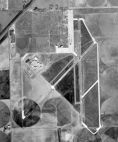 |
| 1996 USGS Photo |
| IATA: DHT – ICAO: KDHT – FAA LID: DHT |
| Summary |
| Airport type |
Public |
| Owner |
City of Dalhart |
| Location |
Hartley County, near Dalhart, Texas |
| Elevation AMSL |
3,991 ft / 1,216 m |
| Runways |
| Direction |
Length |
Surface |
| ft |
m |
| 3/21 |
5,669 |
1,728 |
Asphalt |
| 17/35 |
6,400 |
1,951 |
Asphalt |
| Statistics (2007) |
| Aircraft operations |
22,750 |
| Based aircraft |
36 |
| Source: Federal Aviation Administration |
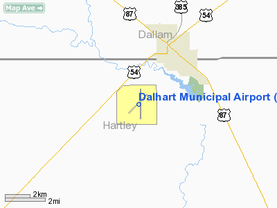
Coordinates: 36°01′21″N 102°32′50″W / 36.0225°N 102.54722°W / 36.0225; -102.54722 Dalhart Municipal Airport (IATA: DHT, ICAO: KDHT, FAA LID: DHT) is a city-owned public-use airport located three miles (5 km) southwest of the central business district of Dalhart, Texas, a city straddling the border of Dallam and Hartley counties in the northwest corner of the Texas Panhandle.
The airport is not served by any commercial airlines at this time. Facilities and aircraft
Dalhart Municipal Airport covers an area of 1,206 acres (488 ha) which contains two asphalt paved runways: 3/21 measuring 5,669 x 75 ft (1,728 x 23 m) and 17/35 measuring 6,400 x 75 ft (1,951 x 23 m).
For the 12-month period ending April 1, 2007, the airport had 22,750 aircraft operations, an average of 62 per day: 99% general aviation and 1% military. There are 36 aircraft based at this airport: 89% single-engine, 8% multi-engine and 3% glider.
History
The airport was constructed by the Army and opened in 1942 as Dalhart Army Air Field. The Army trained B-17 and B-29 pilots at the field during World War II. Known bombardment groups which trained at Dalhart were:
- 6th Bombardment (Very Heavy) (B-29)
- 9th Bombardment (Very Heavy) (B-29)
- 16th Bombardment (Very Heavy) (B-29)
- 331st Bombardment (Very Heavy) (B-29)
- 333d Bombardment (Very Heavy) (B-29)
- 346th Bombardment (Very Heavy) (B-29)
- 382d Bombardment (Heavy) (B-17)
- 383d Bombardment (Heavy) (B-17)
- 415th Bombardment (Dive) (A-20)
- 449th Bombardment (Heavy) (B-17)
- 501st Bombardment (Very Heavy) (B-29)
- 502d Bombardment (Very Heavy) (B-29)
- 504th Bombardment (Very Heavy) (B-29)
- 505th Bombardment (Very Heavy) (B-29)
- 507th Bombardment (Very Heavy) (B-29)
After the war in 1946 it was turned over the city of Dalhart and converted into a municipal airport.
The above content comes from Wikipedia and is published under free licenses – click here to read more.
Location & QuickFacts
| FAA Information Effective: | 2008-09-25 |
| Airport Identifier: | DHT |
| Airport Status: | Operational |
| Longitude/Latitude: | 102-32-50.1990W/36-01-21.3060N
-102.547278/36.022585 (Estimated) |
| Elevation: | 3991 ft / 1216.46 m (Surveyed) |
| Land: | 1206 acres |
| From nearest city: | 3 nautical miles SW of Dalhart, TX |
| Location: | Hartley County, TX |
| Magnetic Variation: | 09E (1995) |
Owner & Manager
| Ownership: | Publicly owned |
| Owner: | City Of Dalhart |
| Address: | Po Box 2004
Dalhart, TX 79022 |
| Phone number: | 806-244-5511 |
| Manager: | Greg Duggan
CITY MGR. |
| Address: | Po Box 2004
Dalhart, TX 79022 |
| Phone number: | 806-244-5511 |
Airport Operations and Facilities
| Airport Use: | Open to public |
| Wind indicator: | Yes |
| Segmented Circle: | Yes |
| Control Tower: | No |
| Lighting Schedule: | DUSK-DAWN
MIRL RYS 03/21 & 17/35 PRESET LOW INTST; TO INCR INTST & ACTVT PAPI RYS 17 & 35 - CTAF. |
| Beacon Color: | Clear-Green (lighted land airport) |
| Landing fee charge: | No |
| Sectional chart: | Wichita |
| Region: | ASW - Southwest |
| Traffic Pattern Alt: | 1000 ft |
| Boundary ARTCC: | ZAB - Albuquerque |
| Tie-in FSS: | FTW - Fort Worth |
| FSS Phone: | 817-541-3474 |
| FSS Toll Free: | 1-800-WX-BRIEF |
| NOTAMs Facility: | DHT (NOTAM-d service avaliable) |
| Federal Agreements: | NGRY |
Airport Communications
| CTAF: | 122.950 |
| Unicom: | 122.950 |
Airport Services
| Fuel available: | 100LLA1
FOR FUEL AFT HRS CALL 806-249-4490. |
| Airframe Repair: | MAJOR |
| Power Plant Repair: | MAJOR |
| Bottled Oxygen: | NONE |
| Bulk Oxygen: | HIGH |
Runway Information
Runway 03/21
| Dimension: | 5669 x 75 ft / 1727.9 x 22.9 m |
| Surface: | ASPH, Good Condition |
| Weight Limit: | Single wheel: 30000 lbs. |
| Edge Lights: | Medium |
| |
Runway 03 |
Runway 21 |
| Longitude: | 102-33-18.1433W | 102-32-29.4829W |
| Latitude: | 36-01-02.4619N | 36-01-42.2037N |
| Elevation: | 3983.00 ft | 3982.00 ft |
| Alignment: | 45 | 127 |
| Traffic Pattern: | Left | Left |
| Markings: | Basic, Good Condition | Basic, Good Condition |
| Displaced threshold: | 0.00 ft | 224.00 ft |
|
Runway 17/35
| Dimension: | 6400 x 75 ft / 1950.7 x 22.9 m |
| Surface: | ASPH, Good Condition |
| Weight Limit: | Single wheel: 20000 lbs.
Dual wheel: 30000 lbs. |
| Edge Lights: | Medium |
| |
Runway 17 |
Runway 35 |
| Longitude: | 102-32-47.0730W | 102-32-46.9241W |
| Latitude: | 36-01-52.0390N | 36-00-48.7547N |
| Elevation: | 3990.00 ft | 3986.00 ft |
| Alignment: | 127 | 127 |
| Traffic Pattern: | Left | Left |
| Markings: | Non-precision instrument, Good Condition | Non-precision instrument, Good Condition |
| Crossing Height: | 25.00 ft | 39.00 ft |
| VASI: | 4-light PAPI on left side | 4-light PAPI on left side |
| Visual Glide Angle: | 3.00° | 3.00° |
| Runway End Identifier: | Yes | Yes |
|
Radio Navigation Aids
| ID |
Type |
Name |
Ch |
Freq |
Var |
Dist |
| DUX | NDB | Durrett | | 414.00 | 09E | 27.7 nm |
| CAO | NDB | Clayton | | 332.00 | 09E | 38.7 nm |
| BCY | NDB | Thorp | | 212.00 | 10E | 44.0 nm |
| DHT | VORTAC | Dalhart | 057X | 112.00 | 12E | 4.1 nm |
Remarks
- LARGE FLOCKS OF WATERFOWL INVOF LAKE RITA BLANCA 2 MI EAST DURING FALL.
- TWY A CLSD INDEFLY.
- TWY B CLSD INDEFLY.
Images and information placed above are from
http://www.airport-data.com/airport/DHT/
We thank them for the data!
| General Info
|
| Country |
United States
|
| State |
TEXAS
|
| FAA ID |
DHT
|
| Latitude |
36-01-21.306N
|
| Longitude |
102-32-50.199W
|
| Elevation |
3991 feet
|
| Near City |
DALHART
|
We don't guarantee the information is fresh and accurate. The data may
be wrong or outdated.
For more up-to-date information please refer to other sources.
|
|


