 |
|
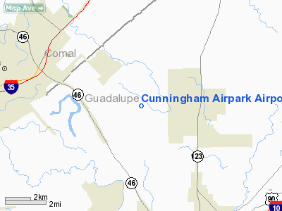
Cunningham Airpark Airport |
Location & QuickFacts
| FAA Information Effective: | 2008-09-25 |
| Airport Identifier: | TX09 |
| Airport Status: | Operational |
| Longitude/Latitude: | 098-00-46.0000W/29-40-32.0000N
-98.012778/29.675556 (Estimated) |
| Elevation: | 617 ft / 188.06 m (Estimated) |
| Land: | 0 acres |
| From nearest city: | 7 nautical miles SS of New Braunfels, TX |
| Location: | Guadalupe County, TX |
| Magnetic Variation: | () |
Owner & Manager
| Ownership: | Privately owned |
| Owner: | Thomas & Margaret Cunningham |
| Address: | 2608 Silver State Lane
New Braunfels, TX 78130 |
| Phone number: | 830-627-1023 |
| Manager: | Thomas Cunningham |
| Address: | 2608 Silver State Lane
New Braunfels, TX 78130 |
| Phone number: | 830-620-0764 |
Airport Operations and Facilities
| Airport Use: | Private |
| Wind indicator: | Yes |
| Control Tower: | No |
| Sectional chart: | San Antonio |
| Region: | ASW - Southwest |
| Boundary ARTCC: | ZHU - Houston |
| Tie-in FSS: | SJT - San Angelo |
| FSS Toll Free: | 1-800-WX-BRIEF |
Runway Information
Runway 08/26
| Dimension: | 1630 x 60 ft / 496.8 x 18.3 m |
| Surface: | TURF, |
| |
Runway 08 |
Runway 26 |
| Traffic Pattern: | Left | Left |
|
Runway 17/35
| Dimension: | 1000 x 60 ft / 304.8 x 18.3 m |
| Surface: | TURF, |
| |
Runway 17 |
Runway 35 |
| Traffic Pattern: | Left | Left |
| Obstruction: | | 25 ft pline, 300.0 ft from runway |
|
Radio Navigation Aids
| ID |
Type |
Name |
Ch |
Freq |
Var |
Dist |
| CVB | NDB | Castroville | | 338.00 | 08E | 48.0 nm |
| DHK | TACAN | Randolph | 036X | | 09E | 15.7 nm |
| KSY | TACAN | Kelly | 057X | | 07E | 34.3 nm |
| SSF | VOR | Stinson | | 108.40 | 09E | 33.7 nm |
| RND | VORTAC | Randolph | 70X | 112.30 | 09E | 17.1 nm |
| SAT | VORTAC | San Antonio | 115X | 116.80 | 08E | 23.5 nm |
| STV | VORTAC | Stonewall | 085X | 113.80 | 08E | 48.2 nm |
| CWK | VORTAC | Centex | 075X | 112.80 | 06E | 49.2 nm |
| SAT | VOT | San Antonio Intl | | 110.40 | | 25.4 nm |
Remarks
- PRVDD VFR OPNS AND PRIVATE USE.
Images and information placed above are from
http://www.airport-data.com/airport/TX09/
We thank them for the data!
| General Info
|
| Country |
United States
|
| State |
TEXAS
|
| FAA ID |
TX09
|
| Latitude |
29-41-23.840N
|
| Longitude |
095-50-22.826W
|
| Elevation |
130 feet
|
| Near City |
FULSHEAR
|
We don't guarantee the information is fresh and accurate. The data may
be wrong or outdated.
For more up-to-date information please refer to other sources.
|
|


