 |
|
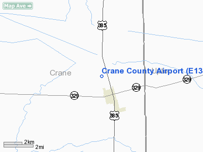
Location & QuickFacts
| FAA Information Effective: | 2008-09-25 |
| Airport Identifier: | E13 |
| Airport Status: | Operational |
| Longitude/Latitude: | 102-21-46.5110W/31-24-54.5020N
-102.362920/31.415139 (Estimated) |
| Elevation: | 2552 ft / 777.85 m (Surveyed) |
| Land: | 250 acres |
| From nearest city: | 1 nautical miles NW of Crane, TX |
| Location: | Crane County, TX |
| Magnetic Variation: | 09E (1985) |
Owner & Manager
| Ownership: | Publicly owned |
| Owner: | Crane County |
| Address: | County Courthouse
Crane, TX 79731 |
| Phone number: | 432-558-3589 |
| Manager: | Todd Seabourn
COUNTY COMMISSIONER. |
| Address: | Po Box 667
Crane, TX 79731 |
| Phone number: | 432-558-1147 |
Airport Operations and Facilities
| Airport Use: | Open to public |
| Wind indicator: | Yes |
| Segmented Circle: | Yes |
| Control Tower: | No |
| Lighting Schedule: | DUSK-DAWN |
| Beacon Color: | Clear-Green (lighted land airport)
ROTG BCN OTS INDEFLY. |
| Landing fee charge: | No |
| Sectional chart: | San Antonio |
| Region: | ASW - Southwest |
| Traffic Pattern Alt: | 800 ft |
| Boundary ARTCC: | ZFW - Fort Worth |
| Tie-in FSS: | SJT - San Angelo |
| FSS on Airport: | No |
| FSS Toll Free: | 1-800-WX-BRIEF |
| NOTAMs Facility: | SJT (NOTAM-d service avaliable) |
Airport Communications
Airport Services
| Fuel available: | 100LL
FOR FUEL CALL 432-558-3572. |
Runway Information
Runway 08/26
| Dimension: | 2290 x 50 ft / 698.0 x 15.2 m |
| Surface: | GRVL, Fair Condition |
| |
Runway 08 |
Runway 26 |
| Traffic Pattern: | Left | Left |
| Obstruction: | 5 ft brush, 34.0 ft from runway, 6:1 slope to clear
4-6 FT BRUSH, 5 FT FENCE OB, 30 FT FM THLD, +10 FT ROAD 50-75 FT FRM THLD OB. ACROSS APCH. | 25 ft pline, 531.0 ft from runway, 21:1 slope to clear |
|
Runway 12/30
| Dimension: | 4145 x 70 ft / 1263.4 x 21.3 m |
| Surface: | ASPH, Good Condition |
| Edge Lights: | Low
LIRL OTS INDEFLY. |
| |
Runway 12 |
Runway 30 |
| Traffic Pattern: | Left | Left |
| Markings: | Basic, Good Condition | Basic, Good Condition |
| Displaced threshold: | 0.00 ft | 449.00 ft |
| VASI: | 2-box on left side | |
| Obstruction: | 4 ft brush, 200.0 ft from runway, 125 ft right of centerline
+4 FT BRUSH ACROSS APCH.
+4 FT FENCE 200 FT FM THLD; DIRT ROAD 125 FT RIGHT OF CNTRLN AT THLD. | 30 ft pline, 930.0 ft from runway, 220 ft right of centerline, 24:1 slope to clear
APCH RATIO 45:1 FM DSPLCD THLD. |
|
Runway 15/33
| Dimension: | 3395 x 50 ft / 1034.8 x 15.2 m |
| Surface: | ASPH, Good Condition |
| |
Runway 15 |
Runway 33 |
| Traffic Pattern: | Left | Left |
| Markings: | Basic, Good Condition | Basic, Good Condition |
| Displaced threshold: | 0.00 ft | 176.00 ft |
| Obstruction: | 35 ft tower, 335.0 ft from runway, 120 ft left of centerline, 3:1 slope to clear
WINDMILL 120' LEFT OF EXTDD CNTRLN.
ROAD 150' FM THR ACRS APCH;+5' FENCE 160' FM THR ON CNTRLN. | 30 ft pline, 765.0 ft from runway, 18:1 slope to clear
+30' PLINE ACROSS APCH.
APCH RATIO 31:1 FM DSPLCD THLD TO +30 FT PLINE 941 FT FM DSPLCD THLD ACROSS APCH. |
|
Radio Navigation Aids
| ID |
Type |
Name |
Ch |
Freq |
Var |
Dist |
| OHE | NDB | Monahans | | 214.00 | 09E | 29.5 nm |
| MA | NDB | Farly | | 326.00 | 09E | 34.5 nm |
| MAF | VORTAC | Midland | 095X | 114.80 | 11E | 36.8 nm |
| FST | VORTAC | Fort Stockton | 116X | 116.90 | 11E | 42.0 nm |
| MAF | VOT | Midland International | | 108.20 | | 32.4 nm |
Remarks
- RY 12/30 PRIMARY SFC OBSTRUCTED BY PUMPJACK 85' FM CNTRLN 100' NW OF DSPLCD THR ON RY 30.
Images and information placed above are from
http://www.airport-data.com/airport/E13/
We thank them for the data!
| General Info
|
| Country |
United States
|
| State |
TEXAS
|
| FAA ID |
E13
|
| Latitude |
31-24-54.502N
|
| Longitude |
102-21-46.511W
|
| Elevation |
2552 feet
|
| Near City |
CRANE
|
We don't guarantee the information is fresh and accurate. The data may
be wrong or outdated.
For more up-to-date information please refer to other sources.
|
|


