 |
|
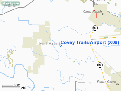
Location & QuickFacts
| FAA Information Effective: | 2008-09-25 |
| Airport Identifier: | X09 |
| Airport Status: | Operational |
| Longitude/Latitude: | 095-50-22.8260W/29-41-23.8400N
-95.839674/29.689956 (Estimated) |
| Elevation: | 130 ft / 39.62 m (Estimated) |
| Land: | 107 acres |
| From nearest city: | 3 nautical miles E of Fulshear, TX |
| Location: | Fort Bend County, TX |
| Magnetic Variation: | 06E (1985) |
Owner & Manager
| Ownership: | Publicly owned |
| Owner: | Covey Trails Civic Club Inc |
| Address: | 18 Kitty Hawk West
Richmond, TX 77469 |
| Phone number: | 281-342-7802 |
| Manager: | Marvin Mixon |
| Address: | 18 West Kitty Hawk
Richmond, TX 77469 |
| Phone number: | 281-342-7802 |
Airport Operations and Facilities
| Airport Use: | Open to public |
| Wind indicator: | Yes |
| Segmented Circle: | No |
| Control Tower: | No |
| Lighting Schedule: | DUSK-2200
ACTVT ROTG BCN AFT 2200 - CTAF. |
| Beacon Color: | Clear-Green (lighted land airport) |
| Landing fee charge: | Yes |
| Sectional chart: | Houston |
| Region: | ASW - Southwest |
| Boundary ARTCC: | ZHU - Houston |
| Tie-in FSS: | CXO - Montgomery County |
| FSS on Airport: | No |
| FSS Toll Free: | 1-800-WX-BRIEF
FOR FP FILING CALL CXO FSS 1-800-833-5602. |
| NOTAMs Facility: | CXO (NOTAM-d service avaliable) |
Airport Communications
| CTAF: | 122.725 |
| Unicom: | 122.725 |
Runway Information
Runway 17/35
| Dimension: | 3365 x 100 ft / 1025.7 x 30.5 m |
| Surface: | TURF, Good Condition |
| Edge Lights: | Non-standard lighting system
NSTD LIRL; 2800 FT OF RY LGTD AT NIGHT BTN DSPLCD THLDS. |
| |
Runway 17 |
Runway 35 |
| Traffic Pattern: | Left | Left |
| Displaced threshold: | 315.00 ft | 250.00 ft |
| Obstruction: | 25 ft pline, 200.0 ft from runway, 8:1 slope to clear
APCH SLOPE 20:1 TO DSPLCD THLD; +25 FT PLINE 515 FT FM DSPLCD THLD ACROSS APCH. | 15 ft road, 32.0 ft from runway, 128 ft left of centerline, 2:1 slope to clear
APCH SLOPE 12:1 TO DSPLCD THLD; +20 FT TREE 240 FT FM DSPLCD THLD 110 FT LEFT. |
|
Radio Navigation Aids
| ID |
Type |
Name |
Ch |
Freq |
Var |
Dist |
| SGR | NDB | Hull | | 388.00 | 05E | 10.2 nm |
| LYD | NDB | Lakeside | | 249.00 | 05E | 11.4 nm |
| EYQ | NDB | Weiser | | 286.00 | 06E | 18.0 nm |
| SYG | NDB | Sandy Point | | 402.00 | 05E | 22.4 nm |
| DWH | NDB | David Hooks | | 521.00 | 05E | 29.8 nm |
| ARM | NDB | Wharton | | 245.00 | 06E | 30.9 nm |
| BVP | NDB | Nixin | | 326.00 | 05E | 37.3 nm |
| JPA | NDB | Sanjac | | 347.00 | 05E | 40.2 nm |
| BNH | NDB | Brenham | | 362.00 | 06E | 42.4 nm |
| BYY | NDB | Bay City | | 344.00 | 06E | 43.1 nm |
| EFD | TACAN | Ellington | 031X | | 05E | 35.9 nm |
| ELA | VOR/DME | Eagle Lake | 111X | 116.40 | 08E | 25.0 nm |
| HUB | VOR/DME | Hobby | 118X | 117.10 | 05E | 29.5 nm |
| IAH | VORTAC | Humble | 113X | 116.60 | 05E | 30.3 nm |
| TNV | VORTAC | Navasota | 106X | 115.90 | 08E | 37.7 nm |
| IDU | VORTAC | Industry | 039X | 110.20 | 08E | 40.9 nm |
| HOU | VOT | Houston Wm P Hobby | | 108.40 | | 29.4 nm |
Remarks
- BASE LEGS AND TURNS TO FINAL APCH MUST BE WITHIN .75 NM OF THE RY ENDS.
- PRVDD ARPT TFC PAT MUST MAINTAIN BASE LEGS AND TURNS TO FINAL APCH WITHIN 0.75 NM OF THE RY ENDS, AND THE SPECIAL SIAP WILL REMAIN UNTIL THE REIMBURSABLE AGREEMENT IS CANCELLED OR FTW FPO IS REQUESTED TO PUBLISH IT.
Images and information placed above are from
http://www.airport-data.com/airport/X09/
We thank them for the data!
|
|


