 |
|
Corpus Christi Intl Airport |
| Corpus Christi International Airport |
 |
| IATA: CRP – ICAO: KCRP – FAA LID: CRP |
| Summary |
| Airport type |
Public |
| Owner |
City of Corpus Christi |
| Serves |
Corpus Christi, Texas |
| Elevation AMSL |
44 ft / 13 m |
| Coordinates |
27°46′13″N 097°30′04″W / 27.77028°N 97.50111°W / 27.77028; -97.50111 |
| Website |
www.cctexas.com/airport/ |
| Runways |
| Direction |
Length |
Surface |
| ft |
m |
| 13/31 |
7,508 |
2,288 |
Asphalt |
| 17/35 |
6,080 |
1,853 |
Asphalt |
| Statistics (2006) |
| Aircraft operations |
97,657 |
| Based aircraft |
76 |
| Source: Federal Aviation Administration |
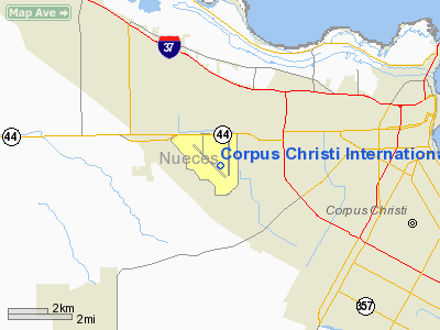
Corpus Christi International Airport (IATA: CRP, ICAO: KCRP, FAA LID: CRP) is a city-owned public-use airport located five nautical miles (9 km) west of the central business district of Corpus Christi, in Nueces County, Texas, United States.
The airport's new six gate, 165,000 sq ft (15,300 m). Hayden W. Head Terminal opened on November 3, 2002, with a theme of "When the Sun Meets the Sea".
The airport has repeatedly attempted to receive service from Mexico, the latest attempt being in 2005, where the airport had reached an agreement with the Mexican regional airline Aeromar, which was supposed to fly 2-3 times a week from Corpus Christi to Monterrey, Mexico on an ATR-42 aircraft and had received Department of Transportation (DOT) approval for the route. The airline still needs DOT approval to fly into the United States, as this will be its first non-Mexican destination except for San Antonio. However, in a letter to the DOT, Aeromar has stated it will not seek renewal of the permit to fly to Corpus Christi.
The airport is frequently used by Continental Airlines and Express and Southwest as a diversion station in case of weather problems in Houston.
With the arrival of the CRJ operated by Chautauqua in the Continental Express fleet, and nearly all flights on Continental being operated by Chautauqua, the airline has set up a crew base with about 75 pilots and flight attendants based at Corpus Christi. Crew base closed November 2008 and now Chautauqua CRJs make up less than 50% of Continental Express flights with Embraer ERJ-145 operated by ExpressJet Airlines making up the majority of flights. Facilities and aircraft
Corpus Christi International Airport covers an area of 2,457 acres (994 ha) at an elevation of 44 feet (13 m) above mean sea level. It has two asphalt paved runways: 13/31 is 7,508 by 150 feet (2,288 x 46 m) and 17/35 is 6,080 by 150 feet (1,853 x 46 m).
For the 12-month period ending June 30, 2006, the airport had 97,657 aircraft operations, an average of 267 per day: 46% military, 29% general aviation, 21% air taxi and 5% scheduled commercial, At that time there were 76 aircraft based at this airport: 53% single-engine, 34% multi-engine, 7% jet, 7% helicopter.
Airlines and destinations
Corpus Christi International Airport has a total of six gates, two of which (Gates 4 and 6) have direct access to the US Customs office. The airport has 5 jetways with one gate accessible via stairs.
| Airlines |
Destinations |
| American Eagle |
Dallas/Fort Worth |
| Continental Express operated by Chautauqua Airlines |
Houston-Intercontinental |
| Continental Express operated by ExpressJet Airlines |
Houston-Intercontinental |
| Southwest Airlines |
Houston-Hobby |
The above content comes from Wikipedia and is published under free licenses – click here to read more.
Location & QuickFacts
| FAA Information Effective: | 2008-09-25 |
| Airport Identifier: | CRP |
| Airport Status: | Operational |
| Longitude/Latitude: | 097-30-04.4000W/27-46-13.3000N
-97.501222/27.770361 (Estimated) |
| Elevation: | 44 ft / 13.41 m (Surveyed) |
| Land: | 2457 acres |
| From nearest city: | 5 nautical miles W of Corpus Christi, TX |
| Location: | Nueces County, TX |
| Magnetic Variation: | 07E (1985) |
Owner & Manager
| Ownership: | Publicly owned |
| Owner: | City Of Corpus Christi |
| Address: | 1201 Leopard St
Corpus Christi, TX 78401-2825 |
| Phone number: | 361-880-3220 |
| Manager: | Fred Segundo |
| Address: | 1000 International Dr
Corpus Christi, TX 78406 |
| Phone number: | 361-289-0171 |
Airport Operations and Facilities
| Airport Use: | Open to public |
| Wind indicator: | Yes |
| Segmented Circle: | No |
| Control Tower: | Yes |
| Lighting Schedule: | DUSK-DAWN |
| Beacon Color: | Clear-Green (lighted land airport) |
| Landing fee charge: | No |
| Sectional chart: | Brownsville |
| Region: | ASW - Southwest |
| Boundary ARTCC: | ZHU - Houston |
| Tie-in FSS: | SJT - San Angelo |
| FSS on Airport: | No |
| FSS Toll Free: | 1-800-WX-BRIEF |
| NOTAMs Facility: | CRP (NOTAM-d service avaliable) |
| Certification type/date: | I C S 05/1973 |
| Federal Agreements: | NGY |
Airport Communications
Airport Services
| Fuel available: | 100LLA |
| Airframe Repair: | MAJOR |
| Power Plant Repair: | MAJOR |
| Bottled Oxygen: | HIGH |
| Bulk Oxygen: | HIGH |
Runway Information
Runway 13/31
| Dimension: | 7508 x 150 ft / 2288.4 x 45.7 m |
| Surface: | ASPH, Good Condition |
| Surface Treatment: | Saw-cut or plastic Grooved |
| Weight Limit: | Single wheel: 150000 lbs.
Dual wheel: 170000 lbs.
Dual tandem wheel: 245000 lbs. |
| Edge Lights: | High |
| |
Runway 13 |
Runway 31 |
| Longitude: | 097-30-48.2030W | 097-29-49.9494W |
| Latitude: | 27-46-37.1971N | 27-45-43.8894N |
| Elevation: | 43.00 ft | 40.00 ft |
| Alignment: | 127 | 127 |
| ILS Type: | ILS/DME
| LOC/DME
|
| Traffic Pattern: | Right | Left |
| Markings: | Precision instrument, Good Condition | Precision instrument, Good Condition |
| Crossing Height: | 51.00 ft | 54.00 ft |
| VASI: | 4-light PAPI on left side | 4-light PAPI on left side |
| Visual Glide Angle: | 3.00° | 3.00° |
| RVR Equipment: | touchdown | |
| Approach lights: | MALSR | MALSR |
| Obstruction: | 33 ft pole, 1782.0 ft from runway, 640 ft left of centerline, 47:1 slope to clear | , 50:1 slope to clear |
| Decleard distances: | Take off run available 7508.00 ft
Take off distance available 7508.00 ft
Actual stop distance available 7508.00 ft
Landing distance available 7508.00 ft
| Take off run available 7508.00 ft
Take off distance available 7508.00 ft
Actual stop distance available 7508.00 ft
Landing distance available 7508.00 ft
|
|
Runway 17/35
| Dimension: | 6080 x 150 ft / 1853.2 x 45.7 m |
| Surface: | ASPH, Good Condition |
| Surface Treatment: | Saw-cut or plastic Grooved |
| Weight Limit: | Single wheel: 150000 lbs.
Dual wheel: 170000 lbs.
Dual tandem wheel: 245000 lbs. |
| Edge Lights: | High |
| |
Runway 17 |
Runway 35 |
| Longitude: | 097-29-46.7627W | 097-29-45.7113W |
| Latitude: | 27-46-46.7311N | 27-45-46.5354N |
| Elevation: | 40.00 ft | 39.00 ft |
| Alignment: | 127 | 127 |
| ILS Type: | | ILS/DME
|
| Traffic Pattern: | Left | Right |
| Markings: | Precision instrument, Good Condition | Precision instrument, Good Condition |
| Crossing Height: | 52.00 ft | 0.00 ft |
| VASI: | 4-light PAPI on left side | |
| Visual Glide Angle: | 3.00° | 0.00° |
| RVR Equipment: | | touchdown |
| Approach lights: | ODALS | MALSR |
| Obstruction: | 43 ft pole, 1930.0 ft from runway, 402 ft right of centerline, 40:1 slope to clear | , 50:1 slope to clear |
| Decleard distances: | Take off run available 6080.00 ft
Take off distance available 6080.00 ft
Actual stop distance available 6080.00 ft
Landing distance available 6080.00 ft
| Take off run available 6080.00 ft
Take off distance available 6080.00 ft
Actual stop distance available 6080.00 ft
Landing distance available 6080.00 ft
|
|
Radio Navigation Aids
| ID |
Type |
Name |
Ch |
Freq |
Var |
Dist |
| RKP | NDB | Rockport | | 391.00 | 06E | 30.9 nm |
| TKB | NDB | Kleberg County | | 347.00 | 06E | 32.6 nm |
| MNO | NDB | Mellon Ranch | | 375.00 | 06E | 34.4 nm |
| BEA | NDB | Beeville | | 284.00 | 07E | 39.2 nm |
| BKS | NDB | Brooks County | | 353.00 | 06E | 47.3 nm |
| NQI | TACAN | Kingsville | 125X | | 09E | 23.0 nm |
| NOG | TACAN | Orange Grove | 063X | | 09E | 29.7 nm |
| ALI | VOR | Alice | | 114.50 | 06E | 27.7 nm |
| CRP | VORTAC | Corpus Christi | 102X | 115.50 | 09E | 8.6 nm |
| NGP | VORTAC | Truax | 087X | 114.00 | 06E | 12.1 nm |
Remarks
- CABANISS FIELD LCTD 5 MILES SE OF ARPT MAY BE MISTAKEN FOR CORPUS CHRISTI INTL ARPT. VFR TFC MAY BE OPERATING IN THE CABANISS FIELD TFC PATTERN.
- BIRDS ON & INVOF ARPT YEAR ROUND.
- CUDDIHY FIELD (CLSD ARPT) IS LCTD 4 MILES SOUTH OF ARPT MAY BE MISTAKEN FOR CORPUS CHRISTI INTL ARPT.
Images and information placed above are from
http://www.airport-data.com/airport/CRP/
We thank them for the data!
| General Info
|
| Country |
United States
|
| State |
TEXAS
|
| FAA ID |
CRP
|
| Latitude |
27-46-13.300N
|
| Longitude |
097-30-04.400W
|
| Elevation |
44 feet
|
| Near City |
CORPUS CHRISTI
|
We don't guarantee the information is fresh and accurate. The data may
be wrong or outdated.
For more up-to-date information please refer to other sources.
|
|


