|
|
| Childress Municipal Airport |
 |
| IATA: CDS – ICAO: KCDS |
| Summary |
| Airport type |
Public |
| Owner |
City of Childress, Texas |
| Operator |
1,954 |
| Serves |
City of Childress, Texas |
| Location |
Childress, Texas |
| Elevation AMSL |
595.6 ft / m |
| Coordinates |
34°26′01.6104″N 100°17′16.7704″W / 34.433780667°N 100.287991778°W / 34.433780667; -100.287991778Coordinates: 34°26′01.6104″N 100°17′16.7704″W / 34.433780667°N 100.287991778°W / 34.433780667; -100.287991778 |
| Runways |
| Direction |
Length |
Surface |
| ft |
m |
| 17/35 |
5,949 |
1,813 |
Asphalt |
| 4/22 |
4,425 |
1,349 |
Asphalt |
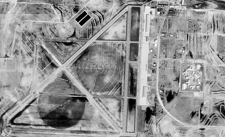
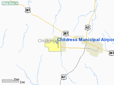
Childress Municipal Airport (IATA: CDS, ICAO: KCDS) is a commercial airport located within city limits, 4 miles (6.4 km) west of central Childress, Texas.
It is owned and operated by the city of Childress, Texas. History
 | |
AAF Bombardier School patch, 1943 |
The airport was opened in October 1942 as Childress Army Airfield and was used by the United States Army Air Forces as a training base.
Childress AAF operated as a bombardier-training school under the Central Flying Training Command. It occupied an area of 2,474 acres (10.01 km). Construction of the field was announced on 2 May 1942, and began immediately thereafter. An activation ceremony was held in October 1942, and Col. John W. White assumed command on 24 November.
The first class of cadets began training in February 1943 and graduated in May. Members of this class were dubbed the "Valentine of Steel" class, in reference to a dummy bomb that Mrs. White decorated as a Valentine to Hitler. Subsequent classes arrived at three-week intervals through the rest of the war and participated in an initial training program of eighteen weeks, later increased to twenty-four. Those who completed the work were designated flight officers or commissioned as second lieutenants.
The base produced the first classes qualified in both precision bombing and dead-reckoning navigation. In 3½ years Childress AAF graduated thirty-five classes of bombardier-navigators; its 4,791 graduates made a tenth of the total World War II air force bombardier production.
The first "All-American Precision Bombing Olympics" was held at Childress in May 1943 with seven air fields participating. Such meets were held there and at other training bases at three-week intervals thereafter until April 1944. A special practice feature was skip-bombing on Lake Childress.
A redeployment program for veteran bombardiers was instituted at the field to give retraining in line with development of bombing techniques. The War Department also established a prisoner of war camp at the base. Childress was renamed the 2512th Army Air Forces Base Unit on July 1, 1944.
After the field was closed on December 21, 1945, it was given to the city and transformed into a municipal airport.
The above content comes from Wikipedia and is published under free licenses – click here to read more.
Location & QuickFacts
| FAA Information Effective: | 2008-09-25 |
| Airport Identifier: | CDS |
| Airport Status: | Operational |
| Longitude/Latitude: | 100-17-16.7704W/34-26-01.6104N
-100.287992/34.433781 (Estimated) |
| Elevation: | 1954 ft / 595.58 m (Surveyed) |
| Land: | 2500 acres |
| From nearest city: | 4 nautical miles W of Childress, TX |
| Location: | Childress County, TX |
| Magnetic Variation: | 10E (1965) |
Owner & Manager
| Ownership: | Publicly owned |
| Owner: | City Of Childress
JERRY CUMMINGS, CITY MANAGER. |
| Address: | 315 Commerce Street
Childress, TX 79201 |
| Phone number: | 940-937-3684 |
| Manager: | Jim Smith |
| Address: | 902 Ave B Nw
Childress, TX 79201 |
| Phone number: | 940-937-8309 |
Airport Operations and Facilities
| Airport Use: | Open to public |
| Wind indicator: | Yes |
| Segmented Circle: | Yes |
| Control Tower: | No |
| Lighting Schedule: | DUSK-DAWN
MIRL RY 17/35 PRESET LOW INTST; TO INCR INTST ACTVT - CTAF. |
| Beacon Color: | Clear-Green (lighted land airport) |
| Landing fee charge: | No |
| Sectional chart: | Dallas-ft Worth |
| Region: | ASW - Southwest |
| Boundary ARTCC: | ZFW - Fort Worth |
| Tie-in FSS: | FTW - Fort Worth |
| FSS on Airport: | No |
| FSS Phone: | 817-541-3474 |
| FSS Toll Free: | 1-800-WX-BRIEF |
| NOTAMs Facility: | CDS (NOTAM-d service avaliable) |
| Federal Agreements: | GPY |
Airport Communications
| CTAF: | 122.800 |
| Unicom: | 122.800 |
Airport Services
| Fuel available: | 100LLA
FOR FUEL AFT HRS CALL 940-937-2546/2547. |
Runway Information
Runway 04/22
| Dimension: | 4425 x 60 ft / 1348.7 x 18.3 m |
| Surface: | ASPH, Poor Condition
RY NOT MAINTAINED; GRASS ENCROACHING UP THRU PAVEMENT. |
| Weight Limit: | Single wheel: 21000 lbs. |
| |
Runway 04 |
Runway 22 |
| Longitude: | 100-17-46.4157W | 100-17-07.8451W |
| Latitude: | 34-25-54.8171N | 34-26-24.7271N |
| Elevation: | 1942.00 ft | 1949.00 ft |
| Alignment: | 47 | 127 |
| Traffic Pattern: | Left | Left |
| Markings: | Basic, Fair Condition | Basic, Fair Condition |
|
Runway 17/35
| Dimension: | 5949 x 75 ft / 1813.3 x 22.9 m |
| Surface: | ASPH, Good Condition
RY NOT MAINTAINED; GRASS ENCROACHING UP THRU PAVEMENT. |
| Weight Limit: | Single wheel: 21000 lbs. |
| Edge Lights: | Medium |
| |
Runway 17 |
Runway 35 |
| Longitude: | 100-17-07.9057W | 100-17-10.2210W |
| Latitude: | 34-26-24.9455N | 34-25-26.1325N |
| Elevation: | 1949.00 ft | 1954.00 ft |
| Alignment: | 127 | 2 |
| Traffic Pattern: | Left | Left |
| Markings: | Non-precision instrument, Good Condition | Non-precision instrument, Good Condition |
| Crossing Height: | 40.00 ft | 40.00 ft |
| VASI: | 2-light PAPI on left side | 2-light PAPI on left side |
| Visual Glide Angle: | 3.00° | 3.00° |
| Obstruction: | 25 ft pole, 1090.0 ft from runway, 396 ft left of centerline, 35:1 slope to clear
+10 FT ROAD 25 FT FM RY END 0B. | , 50:1 slope to clear
+10 FT ROAD 78 FT FM RY END 0B. |
|
Radio Navigation Aids
| ID |
Type |
Name |
Ch |
Freq |
Var |
Dist |
| CDS | VORTAC | Childress | 123X | 117.60 | 10E | 3.9 nm |
| GTH | VORTAC | Guthrie | 092X | 114.50 | 10E | 39.5 nm |
Remarks
- SOME TWYS ROUGH DUE TO GRASS & WEED ENCROACHMENT.
Images and information placed above are from
http://www.airport-data.com/airport/CDS/
We thank them for the data!
| General Info
|
| Country |
United States
|
| State |
TEXAS
|
| FAA ID |
CDS
|
| Latitude |
34-26-01.610N
|
| Longitude |
100-17-16.770W
|
| Elevation |
1954 feet
|
| Near City |
CHILDRESS
|
We don't guarantee the information is fresh and accurate. The data may
be wrong or outdated.
For more up-to-date information please refer to other sources.
|
|