|
|
| Chambers County Airport |
 |
| IATA: none – ICAO: none – FAA LID: T00 |
| Summary |
| Airport type |
Public |
| Owner |
Chambers County |
| Operator |
Ron Jackson |
| Serves |
Anahuac |
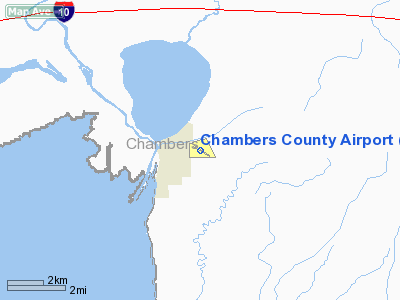
| Location |
Chambers County, Texas |
| Elevation AMSL |
21 ft / 6.4 m |
| Coordinates |
29°46′11″N 094°39′48″W / 29.76972°N 94.66333°W / 29.76972; -94.66333 |
| Runways |
| Direction |
Length |
Surface |
| ft |
m |
| 12/30 |
3005 |
579 |
Asphalt |
| 17/35 |
1900 |
579 |
Turf |
| Statistics (2007) |
| Aircraft based on field |
12 |
| Single Engine Aircraft |
10 |
| Helicopters |
1 |
| Ultralights |
1 |
| Source: Airnav |
Chambers County Airport (FAA LID: T00) (also known as Oscar F. Nelson, Jr. Memorial Airport) is a county-owned general aviation airport located in unincorporated Chambers County, Texas, United States 20 miles (32 km) east of the city of Anahuac.
Terminal procedures (Instrument Approach Procedures)
The above content comes from Wikipedia and is published under free licenses – click here to read more.
Location & QuickFacts
| FAA Information Effective: | 2008-09-25 |
| Airport Identifier: | T00 |
| Airport Status: | Operational |
| Longitude/Latitude: | 094-39-48.5535W/29-46-11.3332N
-94.663487/29.769815 (Estimated) |
| Elevation: | 21 ft / 6.40 m (Surveyed) |
| Land: | 216 acres |
| From nearest city: | 1 nautical miles E of Anahuac, TX |
| Location: | Chambers County, TX |
| Magnetic Variation: | 05E (1995) |
Owner & Manager
| Ownership: | Publicly owned |
| Owner: | Chambers County |
| Address: | Chambers County Courthouse
Anahuac, TX 77514 |
| Phone number: | 409-267-8322 |
| Manager: | Ron Jackson |
| Address: | Po Box 938
Anahuac, TX 77514 |
| Phone number: | 409-267-8358 |
Airport Operations and Facilities
| Airport Use: | Open to public |
| Wind indicator: | Yes |
| Segmented Circle: | Yes |
| Control Tower: | No |
| Lighting Schedule: | DUSK-DAWN
MIRL RY 12/30 PRESET LOW INTST; TO INCR INTST ACTVT - CTAF. |
| Beacon Color: | Clear-Green (lighted land airport) |
| Landing fee charge: | No |
| Sectional chart: | Houston |
| Region: | ASW - Southwest |
| Boundary ARTCC: | ZHU - Houston |
| Tie-in FSS: | CXO - Montgomery County |
| FSS on Airport: | No |
| FSS Toll Free: | 1-800-WX-BRIEF |
| NOTAMs Facility: | CXO (NOTAM-d service avaliable) |
| Federal Agreements: | NGY |
Airport Communications
Airport Services
| Fuel available: | 100LLA |
| Airframe Repair: | MAJOR |
| Power Plant Repair: | MAJOR |
| Bottled Oxygen: | NONE |
| Bulk Oxygen: | NONE |
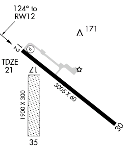
Runway Information
Runway 12/30
| Dimension: | 3005 x 60 ft / 915.9 x 18.3 m |
| Surface: | ASPH, Good Condition |
| Weight Limit: | Single wheel: 13000 lbs. |
| Edge Lights: | Medium |
| |
Runway 12 |
Runway 30 |
| Longitude: | 094-39-57.9635W | 094-39-31.3658W |
| Latitude: | 29-46-21.8392N | 29-46-03.2289N |
| Elevation: | 20.00 ft | 20.00 ft |
| Alignment: | 127 | 127 |
| Traffic Pattern: | Left | Right |
| Markings: | Non-precision instrument, Good Condition | Non-precision instrument, Good Condition |
| Crossing Height: | 28.00 ft | 0.00 ft |
| VASI: | 2-light PAPI on left side | |
| Visual Glide Angle: | 4.00° | 0.00° |
| Obstruction: | 35 ft trees, 525.0 ft from runway, 238 ft left of centerline, 9:1 slope to clear | 15 ft road, 530.0 ft from runway, 280 ft left of centerline, 22:1 slope to clear |
|
Runway 17/35
| Dimension: | 1900 x 300 ft / 579.1 x 91.4 m |
| Surface: | TURF, Good Condition |
| |
Runway 17 |
Runway 35 |
| Longitude: | 094-39-54.7040W | 094-39-54.7040W |
| Latitude: | 29-46-18.8379N | 29-46-00.0300N |
| Elevation: | 20.00 ft | 20.00 ft |
| Alignment: | 127 | 0 |
| Traffic Pattern: | Left | Right |
| Obstruction: | 43 ft trees, 827.0 ft from runway, 19:1 slope to clear | 15 ft road, 230.0 ft from runway, 15:1 slope to clear |
|
Radio Navigation Aids
| ID |
Type |
Name |
Ch |
Freq |
Var |
Dist |
| CBC | NDB | Anahuac | | 413.00 | 05E | 0.2 nm |
| JPA | NDB | Sanjac | | 347.00 | 05E | 22.1 nm |
| GLS | NDB | Galveston | | 206.00 | 08E | 26.6 nm |
| GDE | NDB | Goodhue | | 368.00 | 07E | 30.0 nm |
| BVP | NDB | Nixin | | 326.00 | 05E | 31.7 nm |
| HRD | NDB | Hardin County | | 524.00 | 04E | 40.1 nm |
| SYG | NDB | Sandy Point | | 402.00 | 05E | 45.0 nm |
| ORG | NDB | Orange | | 211.00 | 05E | 48.7 nm |
| EFD | TACAN | Ellington | 031X | | 05E | 27.7 nm |
| MHF | VOR/DME | Trinity | 083X | 113.60 | 07E | 14.1 nm |
| HUB | VOR/DME | Hobby | 118X | 117.10 | 05E | 32.7 nm |
| SBI | VOR/DME | Sabine Pass | 101X | 115.40 | 07E | 33.0 nm |
| BPT | VOR/DME | Beaumont | 092X | 114.50 | 07E | 35.4 nm |
| DAS | VORTAC | Daisetta | 116X | 116.90 | 05E | 25.3 nm |
| VUH | VORTAC | Scholes | 077X | 113.00 | 06E | 31.9 nm |
| IAH | VORTAC | Humble | 113X | 116.60 | 05E | 37.3 nm |
| HOU | VOT | Houston Wm P Hobby | | 108.40 | | 33.0 nm |
Remarks
- RWY 17/35 SOFT WHEN WET.
- RY 17/35 USE EXTREME CARE; PAPI RY 12 IN RY.
Images and information placed above are from
http://www.airport-data.com/airport/T00/
We thank them for the data!
| General Info
|
| Country |
United States
|
| State |
TEXAS
|
| FAA ID |
T00
|
| Latitude |
29-46-12.000N
|
| Longitude |
094-39-49.003W
|
| Elevation |
22 feet
|
| Near City |
ANAHUAC
|
We don't guarantee the information is fresh and accurate. The data may
be wrong or outdated.
For more up-to-date information please refer to other sources.
|
|