 |
|
| Cardiff Brothers Airport |
| IATA: none – ICAO: none – FAA LID: 56TE |
| Summary |
| Airport type |
Private |
| Owner/Operator |
Cardiff Brothers |
| Elevation AMSL |
140 ft / 43 m |
| Coordinates |
29°43′45.835″N 095°50′58.827″W / 29.72939861°N 95.84967417°W / 29.72939861; -95.84967417Coordinates: 29°43′45.835″N 095°50′58.827″W / 29.72939861°N 95.84967417°W / 29.72939861; -95.84967417 |
| Runways |
| Direction |
Length |
Surface |
| ft |
m |
| 17/35 |
3,000 |
914 |
Turf |
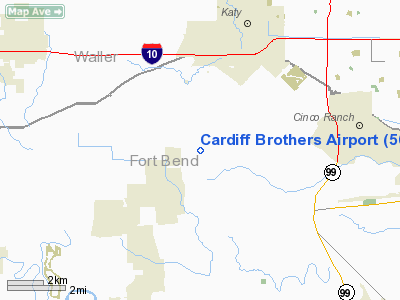
Cardiff Brothers Airport (FAA LID: 56TE) is an airport located in unincorporated Fort Bend County, Texas, United States, east of the city of Fulshear and south of the city of Katy.
The airport is owned by "Cardiff Brothers" of Katy, Texas. The manager is Hal V. Cardiff.
The above content comes from Wikipedia and is published under free licenses – click here to read more.
Location & QuickFacts
| FAA Information Effective: | 2008-09-25 |
| Airport Identifier: | 56TE |
| Airport Status: | Operational |
| Longitude/Latitude: | 095-50-58.8270W/29-43-45.8350N
-95.849674/29.729399 (Estimated) |
| Elevation: | 140 ft / 42.67 m (Estimated) |
| Land: | 0 acres |
| From nearest city: | 3 nautical miles SS of Katy, TX |
| Location: | Fort Bend County, TX |
| Magnetic Variation: | 06E (1985) |
Owner & Manager
| Ownership: | Privately owned |
| Owner: | Cardiff Brothers |
| Address: | 3139 Katy-hockley Road
Katy, TX 77493 |
| Phone number: | 281-391-3554 |
| Manager: | Hal V. Cardiff |
| Address: | 3139 Katy-hockley Road
Katy, TX 77493 |
| Phone number: | 281-391-3554 |
Airport Operations and Facilities
| Airport Use: | Private |
| Wind indicator: | No |
| Segmented Circle: | No |
| Control Tower: | No |
| Landing fee charge: | No |
| Sectional chart: | Houston |
| Region: | ASW - Southwest |
| Boundary ARTCC: | ZHU - Houston |
| Tie-in FSS: | CXO - Montgomery County |
| FSS on Airport: | No |
| FSS Toll Free: | 1-800-WX-BRIEF
FOR FP FILING CALL CXO FSS 1-800-833-5602. |
Airport Services
| Airframe Repair: | NONE |
| Power Plant Repair: | NONE |
Runway Information
Runway 17/35
| Dimension: | 3000 x 100 ft / 914.4 x 30.5 m |
| Surface: | TURF, |
| |
Runway 17 |
Runway 35 |
| Traffic Pattern: | Left | Left |
|
Radio Navigation Aids
| ID |
Type |
Name |
Ch |
Freq |
Var |
Dist |
| LYD | NDB | Lakeside | | 249.00 | 05E | 10.4 nm |
| SGR | NDB | Hull | | 388.00 | 05E | 11.7 nm |
| EYQ | NDB | Weiser | | 286.00 | 06E | 16.4 nm |
| SYG | NDB | Sandy Point | | 402.00 | 05E | 24.2 nm |
| DWH | NDB | David Hooks | | 521.00 | 05E | 28.0 nm |
| ARM | NDB | Wharton | | 245.00 | 06E | 32.6 nm |
| BVP | NDB | Nixin | | 326.00 | 05E | 36.7 nm |
| BNH | NDB | Brenham | | 362.00 | 06E | 40.3 nm |
| JPA | NDB | Sanjac | | 347.00 | 05E | 40.9 nm |
| BYY | NDB | Bay City | | 344.00 | 06E | 45.5 nm |
| EFD | TACAN | Ellington | 031X | | 05E | 36.8 nm |
| ELA | VOR/DME | Eagle Lake | 111X | 116.40 | 08E | 24.7 nm |
| HUB | VOR/DME | Hobby | 118X | 117.10 | 05E | 30.2 nm |
| IAH | VORTAC | Humble | 113X | 116.60 | 05E | 29.6 nm |
| TNV | VORTAC | Navasota | 106X | 115.90 | 08E | 35.3 nm |
| IDU | VORTAC | Industry | 039X | 110.20 | 08E | 39.6 nm |
| HOU | VOT | Houston Wm P Hobby | | 108.40 | | 30.2 nm |
Remarks
Images and information placed above are from
http://www.airport-data.com/airport/56TE/
We thank them for the data!
| General Info
|
| Country |
United States
|
| State |
TEXAS
|
| FAA ID |
56TE
|
| Latitude |
29-43-45.835N
|
| Longitude |
095-50-58.827W
|
| Elevation |
140 feet
|
| Near City |
KATY
|
We don't guarantee the information is fresh and accurate. The data may
be wrong or outdated.
For more up-to-date information please refer to other sources.
|
|


