 |
|
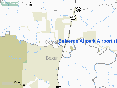
Location & QuickFacts
| FAA Information Effective: | 2008-09-25 |
| Airport Identifier: | 1T8 |
| Airport Status: | Operational |
| Longitude/Latitude: | 098-27-04.0610W/29-44-20.8000N
-98.451128/29.739111 (Estimated) |
| Elevation: | 1080 ft / 329.18 m (Estimated) |
| Land: | 35 acres |
| From nearest city: | 16 nautical miles N of San Antonio, TX |
| Location: | Comal County, TX |
| Magnetic Variation: | 07E (1985) |
Owner & Manager
| Ownership: | Privately owned |
| Owner: | Markline Properties Inc |
| Address: | P.o. Box 130
Bulverde, TX 78163 |
| Phone number: | 830-438-2507 |
| Manager: | Ed Markline |
| Address: | P.o. Box 130
Bulverde, TX 78163 |
| Phone number: | 830-438-2507 |
Airport Operations and Facilities
| Airport Use: | Open to public |
| Wind indicator: | Yes |
| Segmented Circle: | Yes |
| Control Tower: | No |
| Lighting Schedule: | DUSK-2200
ACTVT ROTG BCN AFT 2200 - CTAF. |
| Beacon Color: | Clear-Green (lighted land airport) |
| Landing fee charge: | Yes |
| Sectional chart: | San Antonio |
| Region: | ASW - Southwest |
| Traffic Pattern Alt: | 920 ft |
| Boundary ARTCC: | ZHU - Houston |
| Tie-in FSS: | SJT - San Angelo |
| FSS on Airport: | No |
| FSS Toll Free: | 1-800-WX-BRIEF |
| NOTAMs Facility: | SJT (NOTAM-d service avaliable) |
Airport Communications
| CTAF: | 122.800 |
| Unicom: | 122.800 |
Airport Services
| Fuel available: | 100LL
NO CREDIT CARDS FOR FUEL PURCHASES. |
| Airframe Repair: | MAJOR |
| Power Plant Repair: | MAJOR |
Runway Information
Runway 16/34
| Dimension: | 2890 x 40 ft / 880.9 x 12.2 m |
| Surface: | ASPH, Fair Condition |
| Edge Lights: | Non-standard lighting system
NSTD LIRL; ONLY CENTER 2775 FT LIGHTED. |
| |
Runway 16 |
Runway 34 |
| Traffic Pattern: | Right | Left |
| Markings: | Nonstandard, Good Condition
RY 16/34 MKD WITH 20 FT HIGH NRS ONLY. | Nonstandard, Good Condition |
| Displaced threshold: | 490.00 ft | 200.00 ft |
| Obstruction: | 36 ft pline, 200.0 ft from runway, 125 ft right of centerline
+6 FT FENCE 100 FT FM THLD ON CNTRLN; +10 FT ROAD 110 FT FM THLD ACROSS CNTRLN. | 18 ft trees, 300.0 ft from runway, 5:1 slope to clear
+10 FT TREE 103 FT FM THLD 80 FT L; +30 FT TREES AT THLD 115 FT R. |
|
Radio Navigation Aids
| ID |
Type |
Name |
Ch |
Freq |
Var |
Dist |
| ER | NDB | Shein | | 263.00 | 08E | 31.0 nm |
| CVB | NDB | Castroville | | 338.00 | 08E | 31.5 nm |
| HMA | NDB | Hondo | | 329.00 | 08E | 43.6 nm |
| HHH | NDB | Devine | | 359.00 | 07E | 44.2 nm |
| PEZ | NDB | Pleasanton | | 275.00 | 07E | 47.3 nm |
| MFS | NDB | Horseshoe Bay Resort | | 403.00 | 07E | 47.4 nm |
| DHK | TACAN | Randolph | 036X | | 09E | 15.5 nm |
| KSY | TACAN | Kelly | 057X | | 07E | 22.0 nm |
| SSF | VOR | Stinson | | 108.40 | 09E | 28.9 nm |
| HDO | VOR/DME | Hondo | 31X | 109.40 | 08E | 44.7 nm |
| SAT | VORTAC | San Antonio | 115X | 116.80 | 08E | 5.7 nm |
| RND | VORTAC | Randolph | 70X | 112.30 | 09E | 15.8 nm |
| STV | VORTAC | Stonewall | 085X | 113.80 | 08E | 31.1 nm |
| CSI | VORTAC | Center Point | 122X | 117.50 | 08E | 41.3 nm |
| SAT | VOT | San Antonio Intl | | 110.40 | | 12.4 nm |
Remarks
- NOISE ABATEMENT PROCEDURES IN EFFECT CTC AMGR 830-438-2507.
- NO TOUCH & GO, STOP & GO, OR LOW APPROACHES.
Images and information placed above are from
http://www.airport-data.com/airport/1T8/
We thank them for the data!
| General Info
|
| Country |
United States
|
| State |
TEXAS
|
| FAA ID |
1T8
|
| Latitude |
29-44-20.800N
|
| Longitude |
098-27-04.061W
|
| Elevation |
1080 feet
|
| Near City |
SAN ANTONIO
|
We don't guarantee the information is fresh and accurate. The data may
be wrong or outdated.
For more up-to-date information please refer to other sources.
|
|


