 |
|
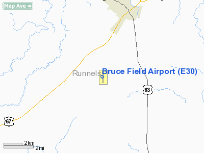
Location & QuickFacts
| FAA Information Effective: | 2008-09-25 |
| Airport Identifier: | E30 |
| Airport Status: | Operational |
| Longitude/Latitude: | 099-58-37.1450W/31-40-28.1510N
-99.976985/31.674486 (Estimated) |
| Elevation: | 1738 ft / 529.74 m (Surveyed) |
| Land: | 640 acres |
| From nearest city: | 5 nautical miles SW of Ballinger, TX |
| Location: | Runnels County, TX |
| Magnetic Variation: | 08E (1995) |
Owner & Manager
| Ownership: | Publicly owned |
| Owner: | City Of Ballinger |
| Address: | Po Box 497
Ballinger, TX 76821 |
| Phone number: | 325-365-5437 |
| Manager: | Brent Allen |
| Address: | 1201 County Rd 240
Ballinger, TX 76821 |
| Phone number: | 325-365-3907 |
Airport Operations and Facilities
| Airport Use: | Open to public |
| Wind indicator: | Yes |
| Segmented Circle: | Yes |
| Control Tower: | No |
| Lighting Schedule: | DUSK-DAWN
ACTVT PAPI RY 17 - CTAF. |
| Beacon Color: | Clear-Green (lighted land airport) |
| Landing fee charge: | No |
| Sectional chart: | San Antonio |
| Region: | ASW - Southwest |
| Boundary ARTCC: | ZFW - Fort Worth |
| Tie-in FSS: | SJT - San Angelo |
| FSS on Airport: | No |
| FSS Toll Free: | 1-800-WX-BRIEF |
| NOTAMs Facility: | SJT (NOTAM-d service avaliable) |
| Federal Agreements: | R |
Airport Communications
Airport Services
| Fuel available: | 100LL
FOR FUEL CALL 325-365-3907/3511/3591/5137. CASH OR CHECK ONLY. |
Runway Information
Runway 17/35
| Dimension: | 3906 x 60 ft / 1190.5 x 18.3 m |
| Surface: | ASPH, Good Condition |
| Weight Limit: | Single wheel: 20000 lbs. |
| Edge Lights: | Medium |
| |
Runway 17 |
Runway 35 |
| Longitude: | 099-58-37.0370W | 099-58-37.2518W |
| Latitude: | 31-40-47.4760N | 31-40-08.8255N |
| Elevation: | 1735.00 ft | 1737.00 ft |
| Alignment: | 127 | 0 |
| Traffic Pattern: | Left | Left |
| Markings: | Non-precision instrument, Fair Condition | Non-precision instrument, Fair Condition |
| Crossing Height: | 39.00 ft | 0.00 ft |
| VASI: | 2-light PAPI on left side | |
| Visual Glide Angle: | 3.00° | 0.00° |
| Obstruction: | 15 ft road, 520.0 ft from runway, 21:1 slope to clear | , 50:1 slope to clear |
|
Radio Navigation Aids
| ID |
Type |
Name |
Ch |
Freq |
Var |
Dist |
| UBC | NDB | Ballinger | | 239.00 | 08E | 0.4 nm |
| IEW | NDB | Winters | | 396.00 | 08E | 16.3 nm |
| COM | NDB | Coleman | | 385.00 | 07E | 30.8 nm |
| BBD | NDB | Brady | | 380.00 | 07E | 44.9 nm |
| DYS | TACAN | Dyess | 063X | | 08E | 45.1 nm |
| TQA | VOR/DME | Tuscola | 053X | 111.60 | 10E | 34.7 nm |
| SJT | VORTAC | San Angelo | 098X | 115.10 | 10E | 30.4 nm |
| ABI | VORTAC | Abilene | 084X | 113.70 | 10E | 48.8 nm |
Remarks
Images and information placed above are from
http://www.airport-data.com/airport/E30/
We thank them for the data!
| General Info
|
| Country |
United States
|
| State |
TEXAS
|
| FAA ID |
E30
|
| Latitude |
31-40-26.550N
|
| Longitude |
099-58-39.103W
|
| Elevation |
1737 feet
|
| Near City |
BALLINGER
|
We don't guarantee the information is fresh and accurate. The data may
be wrong or outdated.
For more up-to-date information please refer to other sources.
|
|


