|
|
| Brownwood Regional Airport |
 |
| IATA: BWD – ICAO: KBWD |
| Summary |
| Airport type |
Public/Military |
| Operator |
City of Brownwood |
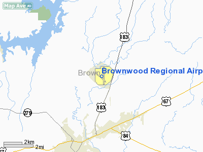
| Location |
Brownwood, Texas |
| Elevation AMSL |
1,387 ft / 423 m |
| Coordinates |
31°47′37.040″N 98°57′23.383″W / 31.7936222°N 98.95649528°W / 31.7936222; -98.95649528Coordinates: 31°47′37.040″N 98°57′23.383″W / 31.7936222°N 98.95649528°W / 31.7936222; -98.95649528 |
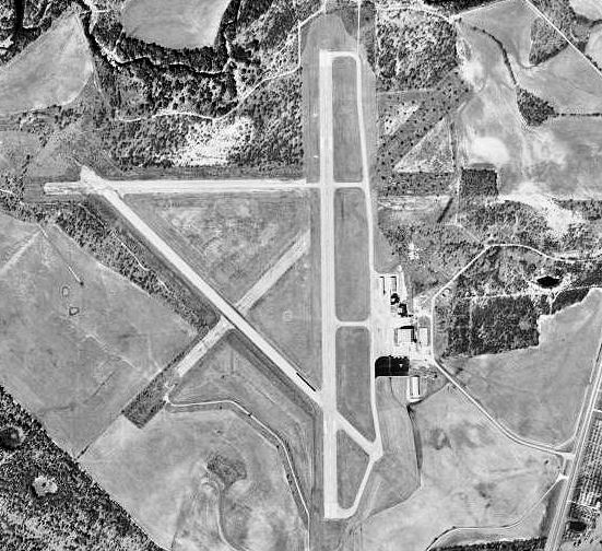
| Runways |
| Direction |
Length |
Surface |
| ft |
m |
| 13/31 |
4,596 |
1,401 |
Asphalt |
| 17/35 |
5,599 |
1,707 |
Asphalt |
Brownwood Regional Airport (IATA: BWD, ICAO: KBWD) is a public airport located in west central Texas, near the cities of Brownwood and Early. The airport has 2 runways 35/17 & 31/13.
Though the airport is used mostly for general aviation, the 21st Cavalry Brigade of the III Corps, U.S. Army, utilize the airport as part of their flight training area for the Apache and Blackhawk helicopters.
History
The airport was opened during World War II as Brownwood Army Airfield and was used by the United States Army Air Forces as a training base.
The 68th and 77th Reconnaissance Groups trained at Brownwood during 1942 with a variety of aircraft, including B-17 Flying Fortresse, B-24 Liberators, P-40 Warhawks and A-20 Havocs. In addition to the training performed at the airfield, patrols were flown over the Gulf of Mexico and along the Mexican border. The role of the Brownwood Army Airfield from November, 1943, to September, 1944 was to operate as a refresher school and replacement training unit for liaison pilots within the Third Air Force. One of the primary aircraft used in this role was the Stinson L-5. In October, 1944, the airfield became the new combat crew training center. From January, 1945, until the end of World War II, the primary mission of the Brownwood Army Airfield was the training and preparation of combat crews for overseas replacement.
The U.S. Government deeded the airport to the City of Brownwood after World War II. There are static displays of an F-4 Phantom and an F-111 jets on the airport grounds.
The above content comes from Wikipedia and is published under free licenses – click here to read more.
Location & QuickFacts
| FAA Information Effective: | 2008-09-25 |
| Airport Identifier: | BWD |
| Airport Status: | Operational |
| Longitude/Latitude: | 098-57-23.3830W/31-47-37.0400N
-98.956495/31.793622 (Estimated) |
| Elevation: | 1387 ft / 422.76 m (Surveyed) |
| Land: | 1497 acres |
| From nearest city: | 5 nautical miles N of Brownwood, TX |
| Location: | Brown County, TX |
| Magnetic Variation: | 08E (1980) |
Owner & Manager
| Ownership: | Publicly owned |
| Owner: | City Of Brownwood |
| Address: | Box 1389
Brownwood, TX 76801 |
| Phone number: | 325-646-5575 |
| Manager: | Sharlette Bain |
| Address: | Box 1389
Brownwood, TX 76801 |
| Phone number: | 325-643-1482 |
Airport Operations and Facilities
| Airport Use: | Open to public |
| Wind indicator: | Yes |
| Segmented Circle: | Yes |
| Control Tower: | No |
| Lighting Schedule: | DUSK-DAWN
ACTVT MIRL RYS 13/31 & 17/35 AND MALS RY 17 - CTAF. |
| Beacon Color: | Clear-Green (lighted land airport) |
| Landing fee charge: | No |
| Sectional chart: | San Antonio |
| Region: | ASW - Southwest |
| Boundary ARTCC: | ZFW - Fort Worth |
| Tie-in FSS: | FTW - Fort Worth |
| FSS on Airport: | No |
| FSS Phone: | 817-541-3474 |
| FSS Toll Free: | 1-800-WX-BRIEF |
| NOTAMs Facility: | BWD (NOTAM-d service avaliable) |
| Federal Agreements: | NGPY3 |
Airport Communications
| CTAF: | 122.800 |
| Unicom: | 122.800 |
Airport Services
| Fuel available: | 100LLA
FOR JET A FUEL WHEN ARPT UNATNDD CALL 325-642-0868. 24 HR SELF SERVICE FOR 100LL. |
| Airframe Repair: | MAJOR |
| Power Plant Repair: | MAJOR |
Runway Information
Runway 13/31
| Dimension: | 4596 x 100 ft / 1400.9 x 30.5 m |
| Surface: | ASPH, Good Condition |
| Weight Limit: | Single wheel: 25000 lbs. |
| Edge Lights: | Medium |
| |
Runway 13 |
Runway 31 |
| Longitude: | 098-57-49.0300W | 098-57-10.9290W |
| Latitude: | 31-47-50.3290N | 31-47-18.5630N |
| Elevation: | 1380.00 ft | 1372.00 ft |
| Alignment: | 127 | 127 |
| Traffic Pattern: | Left | Left |
| Markings: | Basic, Good Condition | Basic, Good Condition |
| Obstruction: | 26 ft tree, 1000.0 ft from runway, 150 ft right of centerline, 30:1 slope to clear | 45 ft trees, 1450.0 ft from runway, 250 ft left of centerline, 27:1 slope to clear |
|
Runway 17/35
| Dimension: | 5599 x 150 ft / 1706.6 x 45.7 m |
| Surface: | ASPH, Good Condition |
| Weight Limit: | Single wheel: 30000 lbs. |
| Edge Lights: | Medium |
| |
Runway 17 |
Runway 35 |
| Longitude: | 098-57-18.2830W | 098-57-17.5570W |
| Latitude: | 31-48-06.7880N | 31-47-11.3900N |
| Elevation: | 1384.00 ft | 1370.00 ft |
| Alignment: | 127 | 127 |
| ILS Type: | LOCALIZER
| |
| Traffic Pattern: | Left | Left |
| Markings: | Non-precision instrument, Good Condition | Non-precision instrument, Good Condition |
| Crossing Height: | 52.00 ft | 0.00 ft |
| VASI: | 4-light PAPI on left side | |
| Visual Glide Angle: | 3.00° | 0.00° |
| Approach lights: | MALS | |
| Obstruction: | 26 ft trees, 1000.0 ft from runway, 225 ft left of centerline, 30:1 slope to clear | 27 ft trees, 1070.0 ft from runway, 250 ft left of centerline, 32:1 slope to clear |
|
Radio Navigation Aids
| ID |
Type |
Name |
Ch |
Freq |
Var |
Dist |
| COM | NDB | Coleman | | 385.00 | 07E | 23.1 nm |
| OIP | NDB | Old Rip | | 410.00 | 07E | 37.1 nm |
| BBD | NDB | Brady | | 380.00 | 07E | 41.5 nm |
| MNZ | NDB | Hamilton | | 251.00 | 07E | 42.7 nm |
| BWD | VOR/DME | Brownwood | 023X | 108.60 | 08E | 5.9 nm |
Remarks
- UNEVEN SFC AT INTERSECTING RYS.
Images and information placed above are from
http://www.airport-data.com/airport/BWD/
We thank them for the data!
| General Info
|
| Country |
United States
|
| State |
TEXAS
|
| FAA ID |
BWD
|
| Latitude |
31-47-37.040N
|
| Longitude |
098-57-23.383W
|
| Elevation |
1387 feet
|
| Near City |
BROWNWOOD
|
We don't guarantee the information is fresh and accurate. The data may
be wrong or outdated.
For more up-to-date information please refer to other sources.
|
|