 |
|
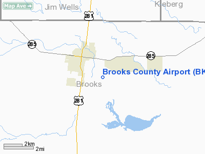
Location & QuickFacts
| FAA Information Effective: | 2008-09-25 |
| Airport Identifier: | BKS |
| Airport Status: | Operational |
| Longitude/Latitude: | 098-07-16.2000W/27-12-24.6000N
-98.121167/27.206833 (Estimated) |
| Elevation: | 112 ft / 34.14 m (Surveyed) |
| Land: | 169 acres |
| From nearest city: | 2 nautical miles SE of Falfurrias, TX |
| Location: | Brooks County, TX |
| Magnetic Variation: | 06E (2000) |
Owner & Manager
| Ownership: | Publicly owned |
| Owner: | Brooks County |
| Address: | Co Commissioners Court
Falfurrias, TX 78355 |
| Phone number: | 361-325-5604
OR 361-325-5676. |
| Manager: | Bond Cosby |
| Address: | Po Box 556
Falfurrias, TX 78355 |
| Phone number: | 361-325-2909 |
Airport Operations and Facilities
| Airport Use: | Open to public |
| Wind indicator: | Yes |
| Segmented Circle: | Yes |
| Control Tower: | No |
| Lighting Schedule: | DUSK-DAWN
ACTVT MIRL RY 17/35 - CTAF. |
| Beacon Color: | Clear-Green (lighted land airport) |
| Landing fee charge: | No |
| Sectional chart: | Brownsville |
| Region: | ASW - Southwest |
| Boundary ARTCC: | ZHU - Houston |
| Tie-in FSS: | SJT - San Angelo |
| FSS on Airport: | No |
| FSS Toll Free: | 1-800-WX-BRIEF |
| NOTAMs Facility: | BKS (NOTAM-d service avaliable) |
| Federal Agreements: | NGY |
Airport Communications
| CTAF: | 122.800 |
| Unicom: | 122.800 |
Airport Services
| Fuel available: | 100LLA |
| Airframe Repair: | NONE |
| Power Plant Repair: | NONE |
| Bottled Oxygen: | NONE |
| Bulk Oxygen: | NONE |
Runway Information
Runway 14/32
| Dimension: | 3071 x 40 ft / 936.0 x 12.2 m |
| Surface: | ASPH, Good Condition |
| Weight Limit: | Single wheel: 4000 lbs.
GROSS ENGINEERING WEIGHT 60000 LBS. (PER AMGR) |
| |
Runway 14 |
Runway 32 |
| Longitude: | 098-07-30.9069W | 098-07-13.6278W |
| Latitude: | 27-12-32.4405N | 27-12-06.2433N |
| Elevation: | 109.00 ft | 112.00 ft |
| Alignment: | 127 | 127 |
| Traffic Pattern: | Left | Left |
| Markings: | Basic, Good Condition | Basic, Good Condition |
| Obstruction: | 12 ft tree, 230.0 ft from runway, 120 ft right of centerline, 2:1 slope to clear
10 FT TREES 100-185 FT FROM THLD, 100 FT RIGHT OF CNTRLN. | , 50:1 slope to clear |
|
Runway 17/35
| Dimension: | 5002 x 75 ft / 1524.6 x 22.9 m |
| Surface: | ASPH, Good Condition |
| Weight Limit: | Single wheel: 52000 lbs.
Dual wheel: 80000 lbs.
GROSS ENGINEERING WEIGHT 60000 LBS. (PER AMGR) |
| Edge Lights: | Medium |
| |
Runway 17 |
Runway 35 |
| Longitude: | 098-07-12.4519W | 098-07-12.3528W |
| Latitude: | 27-12-52.6182N | 27-12-03.0888N |
| Elevation: | 112.00 ft | 112.00 ft |
| Alignment: | 127 | 127 |
| Traffic Pattern: | Left | Left |
| Markings: | Non-precision instrument, Good Condition | Non-precision instrument, Good Condition |
| Runway End Identifier: | Yes | |
| Obstruction: | 31 ft tree, 1024.0 ft from runway, 284 ft right of centerline, 26:1 slope to clear | 15 ft trees, 430.0 ft from runway, 14:1 slope to clear |
|
Radio Navigation Aids
| ID |
Type |
Name |
Ch |
Freq |
Var |
Dist |
| TKB | NDB | Kleberg County | | 347.00 | 06E | 24.1 nm |
| HBV | NDB | Hebbronville | | 266.00 | 06E | 34.4 nm |
| SNE | NDB | Santa Elena | | 260.00 | 07E | 38.2 nm |
| NQI | TACAN | Kingsville | 125X | | 09E | 24.4 nm |
| NOG | TACAN | Orange Grove | 063X | | 09E | 41.6 nm |
| ALI | VOR | Alice | | 114.50 | 06E | 32.5 nm |
Remarks
- 9 FT FENCE LCTD APRXLY 900 FT NORTH OF RY 17 & 400 FT SOUTH OF RY 35.
- EXTREME NOISE SENSITIVE AREAS TO THE NORTH, WEST AND SW OF ARPT ALONG LAKE/RESIDENCE AREA.
Images and information placed above are from
http://www.airport-data.com/airport/BKS/
We thank them for the data!
| General Info
|
| Country |
United States
|
| State |
TEXAS
|
| FAA ID |
BKS
|
| Latitude |
27.206833
27° 12' 24.60" N
|
| Longitude |
-98.121167
098° 07' 16.20" W
|
| Elevation |
112 feet
34 meters
|
| Type |
Civil
|
| Magnetic Variation |
005° E (01/06)
|
| Beacon |
Yes
|
| Operating Agency |
U.S.CIVIL AIRPORT WHEREIN PERMIT COVERS USE BY TRANSIT MILITARY AIRCRAFT
|
| Daylight Saving Time |
Second Sunday in March at 0200 to first Sunday in November at 0200 local time (Exception Arizona and that portion of Indiana in the Eastern Time Zone)
|
We don't guarantee the information is fresh and accurate. The data may
be wrong or outdated.
For more up-to-date information please refer to other sources.
|
|


